Jamestown is a community located in Tuolumne County in the foothills of the Sierra Nevada Mountains. Jamestown was founded during 1848 and is one of the many traditional Gold Rush towns located along California State Route 49. The original alignment of California State Route 49 in Jamestown was located along Main Street. California State Route 49 along Main Street in Jamestown was joined by a multiplex of California State Route 108 likely during the late 1940s. California State Route 49 and California State Route 108 were moved to a bypass alignment west of Main Street in Jamestown during the 1970s. California State Route 49 can be seen passing through Jamestown along Main Street on the
1935 Division of Highways Map of Tuolumne County.
Part 1; the history of California State Route 49-108 in Jamestown
Jamestown was settled one mile from the first mining claim located what is now Tuolumne County during 1848. Jamestown is named after Colonial George F. James who arrived in the community during 1849. Colonial George F. James was a popular merchant in early Jamestown known for supplying champagne to patrons and was once elected community Alcalde. Ultimately, poor mining investments by Colonial George F. James led to the community bearing his name to briefly be renamed American Camp by angry residents.
Jamestown can be seen along the road to Sonora Pass on the 1857 Britton & Rey's Map of California.
The population of Jamestown would peak around 4,000 before a devastating fire struck the community during October 1885. The post-mining era decline of Jamestown was short lived as a community became the headquarters for the Sierra Railway during 1897. Jamestown would never incorporate as a city.
State Highway service would come to Jamestown as part of the 1909 First State Highway Bond Act. The First State Highway Bond Act defined the road from Salida east to Sonora through Jamestown as State Highway. In time the State Highway through Jamestown would come be to be known as
Legislative Route Number 13. The routing of Legislative Route Number 13 through Jamestown was via Main Street.
Legislative Route Number 13 can be seen passing through Jamestown via Main Street on the 1917 California State Automobile Association Map.


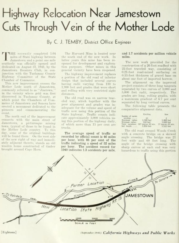
The relocation of California State Route 49/Legislative Route Number 13 south of Jamestown off of what is now Harvard Mine Road was featured in the September 1941 California Highways & Public Works. The new alignment of California State Route 49/Legislative Route Number 13 south of Jamestown was dedicated on August 31, 1941.
The September/October 1948 California Highways & Public Works references California State Route 108 being extended west of Jamestown co-signed with California State Route 49 to an unclear point. A summary of major construction projects cites California State Route 49 and California State Route 108 as being co-signed through Jamestown to at least Montezuma Road.
The bypass of Jamestown alignment of California State Route 49-108 opened after the California Highways & Public Works publication ended during 1967. The illustration below shows the difference between the original routing of California State Route 49-108 on Main Street versus the modern bypass. The California State Route 49-108 appears to have been constructed during the early 1970s.
Part 2; exploring former California State Route 49-108 on Main Street in Jamestown
Originally California State Route 49-108 were aligned through downtown Jamestown on Main Street. Modern California State Route 49-108 bypass downtown Jamestown to the west of Main Street.
Jamestown along Main Street largely appears much as it did during the height of the Gold Rush. Some of the notable structures on Main Street are the1898 Branch Jail, the 1897 Emporium, and the 1880 Jamestown Hotel.


Comments