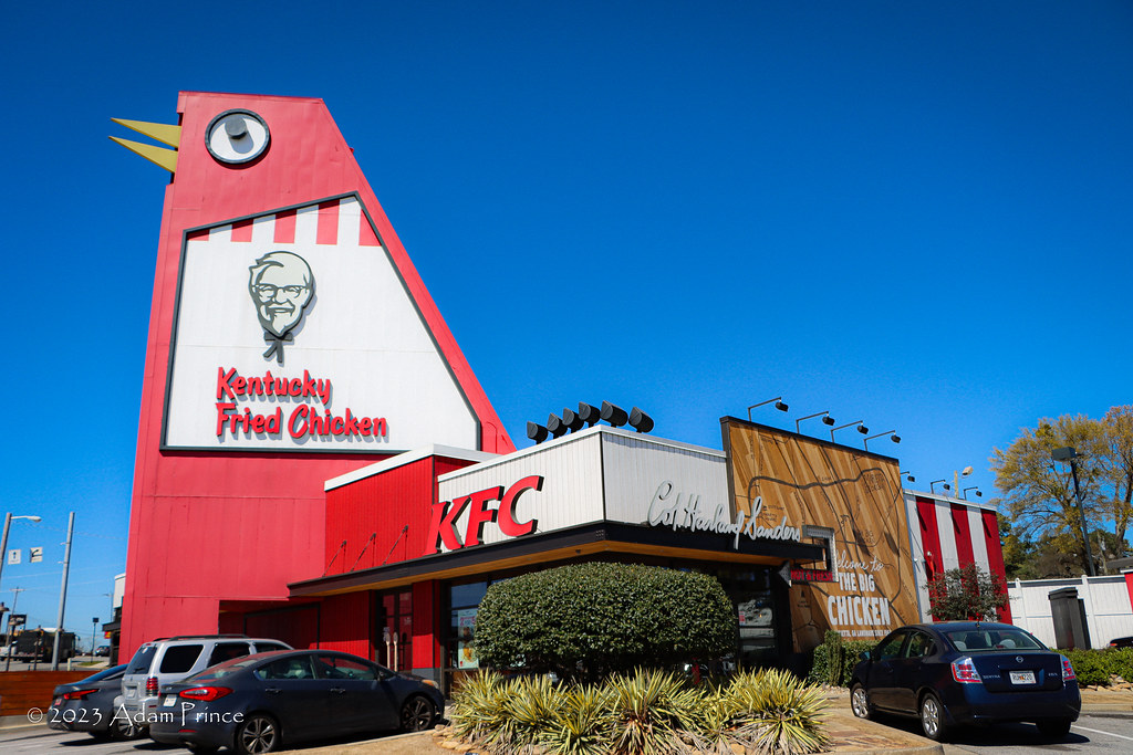
The BBBBIIIIGGGG Chicken - Marietta, GA


"...turn left at the Big Chicken."

Landmarks, before the era of GPS navigation, physical places, man-made or not, were often used in directions to help get from one place to another.

"...one mile South of the Big Chicken."

On US 41 in Marietta, Georgia - a 56-foot tall red-and-white chicken - complete with a moving beak and rolling eyes - dominates the suburban commercial strip.  You can see it from nearby Interstate 75 - it's simply known as The BIG Chicken.

The story of The Big Chicken dates back to 1963. Stanly "Tubby" Davis wanted a unique way to promote his Johnny Reb's Chick-Chuck-'N'-Shake.  The restaurant served fried chicken, hamburgers, and milkshakes.  It also was a drive-in offering curbside service.

Davis commissioned a local Georgia Tech student, Hubert Puckett, to design the roadside attraction.  Puckett would later be involved in renovations to the structure after it sustained significant storm damage in 1993.

Close-up of the moving beak and rolling eyes of The Big Chicken.

Kentucky Fried Chicken would become the new home of The Big Chicken in 1974.  Puckett sold his business to his brother, who would convert Johnny Reb's to a KFC franchise. 

The seven-story attraction has survived numerous attempts to dismantle it.  At first, Kentucky Fried Chicken did not like the locally beloved landmark.  It would later try to move the bird to another Atlanta location.  However, a January 1993 windstorm would cement The Big Chicken permanently at the corner of Cobb Parkway and Roswell.

The 1993 renovated version of The Big Chicken - (Joe Babyak - January 2008)

High winds had dislodged several steel panels from the body of the chicken.  KFC officials were ready to move on and tear it down. Marietta and area residents protested as it had become a local attraction.  Aircraft pilots also stepped in to support The Big Chicken.  They used The Big Chicken as a landmark on their approaches to nearby airports.  KFC relented - and a renovation project would restore the chicken back to operation the following year.

KFC enthusiastically embraced The Big Chicken in the 2017 remodel.

The Big Chicken would undergo a second renovation in 2017.  A $2 million renovation updated the chicken, restaurant, and accompanying gift shop.  The restaurant was updated to modern-KFC standards. And, to show how far KFC-corporate has changed its view of Puckett's chicken, the BIG Chicken is the centerpiece of all the local branding.

All photos taken by post author - March 2023 - unless otherwise noted.

Sources & Links:

How To Get There:

Comments

Popular posts from this blog

Grand Loop Road of Yellowstone National Park

  Grand Loop Road is a 140 mile loop highway which traverses the interior of Yellowstone National Park.  Grand Loop Road connects all of the major attractions and geological features of Yellowstone National Park along with the entrance roads.  Grand Loop Road is a seasonal highway and despite some conjecture never has been part of the US Route System.   Part 1; the history of Grand Loop Road The majority of history pertaining to Grand Loop Road was taken from the below National Park Service article: Historic Roads - Yellowstone National Park (U.S. National Park Service) (nps.gov) Yellowstone was declared the first National Park of the United States on March 1st, 1872.  The first real highway to access Yellowstone National Park came in 1873 when a tolled facility was constructed from Bozeman, Montana via Yankee Jim Canyon to Mammoth Hot Springs.  Numerous attempts were made to fund construction of roadway infrastructure during the early years of Yellows...

The last 1956-63 era California Sign State Route Spade?

Along southbound California State Route 170 (the Hollywood Freeway Extension) approaching the Hollywood Freeway/Ventura Freeway interchange a white California State Route 134 Sign State Route Spade can be observed on guide sign.  These white spades were specifically used during the 1956-63 era and have become increasingly rare.  This blog is intended to serve as a brief history of the Sign State Route Spade.  We also ask you as the reader, is this last 1956-63 era Sign State Route Spade or do you know of others?  Part 1; the history of the California Sign State Route Spade Prior to the Sign State Route System, the US Route System and the Auto Trails were the only highways in California signed with reassurance markers.  The creation of the US Route System by the American Association of State Highway Officials during November 1926 brought a system of standardized reassurance shields to major highways in California.  Early efforts to create a Sign State Route ...

California State Route 70; the Feather River Highway

From 2017 through to early 2019 I drove the majority of the California State Route 70; the Feather River Highway from CA 89 southwest to CA 99. CA 70 is an approximately 178.5 mile state highway which starts at US 395 near the Nevada State Line and travels west through the Feather River Canyon to CA 99.  CA 70 is often referred to as the Feather River Highway" given it's close association with the river.  Historically CA 70 was previously signed as US 40A and CA 24.  The Legislative Routes prior to the 1964 California Highway Renumbering that made up the current route of CA 70 are as follows: -  Legislative Route Number 21 from US 395 westward to Oroville. -  LRN 87 from Oroville south to Marysville. -  LRN 232 from Marysville to the current junction with CA 99.  CA 70 was even dual signed with CA 99 into Sacramento on what was LRN 232 for a time. The change from US 40A/LRN 21/LRN 87/LRN 232 can be seen by comparing the 1963 State Highway Ma...