This previous month has left me with not much to do thanks to all the effects of COVID-19. That being the case I spent some time scoping out ghost town/rail siding sites in Central Fresno County while running an errand. The three ghost towns locations I recently went to visit were; Ivesta, Clotho, and DeWolf.

Part 1; Ivesta and Clotho the Ghost Sidings of the Stockton & Tulare Railroad
Ivesta and Clotho were railroad sidings of the Southern Pacific Railroad spur line known as the Stockton & Tulare Railroad. Ivesta was located on what is now Leonard Avenue whereas Clotho is located about one mile east on what is now McCall Avenue. The Stockton & Tulare Railroad was completed in 1887 but it doesn't appear that Ivesta nor Clotho were among the original sidings. Ivesta and Clotho don't appear on the 1889 George F. Cram Railroad map of California but nearby Butler does to the west on modern Fowler Avenue.

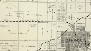
The first reference to any kind of siding facilities on the future sites of Ivesta and Clotho is on the 1891 Thompson Atlas of Fresno County.
A small parcel of land next to the Stockton & Tulare Railroad on what is now Leonard Avenue is shown owned by Margaret Ross at the site of what became Investa. One mile east a small rail siding facility shown as Granville is located on the future site of Clotho. The lack of major sidings in the area makes sense since downtown Sanger is located a short distance to the east.
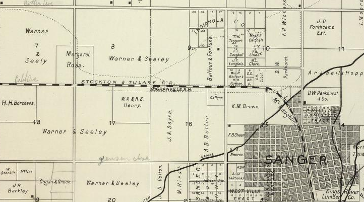
No major sidings appear on the Stockton & Tulare Railroad between Minneola and Sanger on the 1914 C.F. Weber Map of Fresno County.

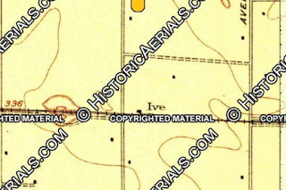
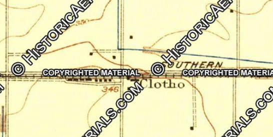
The first true sighting of Ivesta and Clotho I can find is on a 1923 USGS Topographical Map hosted on historicaerials.com. Interestingly Ivesta seems to be referred to as "Ive" on the 1923 USGS Map. Ive appears a minimal siding facility with only a single structure visible. Clotho appears as a fairly decent sized siding with approximately nine structures.

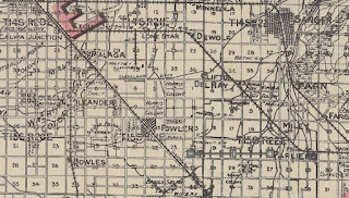
Ivesta and Clotho are both large enough to get mentioned on the 1935 California Division of Highways Map of Fresno County.

Part 1A; a water logged stop at Ivesta
Ivesta still appears on modern Google Map images and has some remaining structures. The main siding building at Ivesta is noted as Hmong Star TV on Google Maps.

My path to Ivesta was east on a water logged Church Avenue. The rains had been heavy the previous week which flooded many of the Fresno County farm roads. Upon reaching Leonard Avenue I made a left hand turn to head north to the site of Ivesta.

Suffice to say Leonard Avenue wasn't in much better shape flood wise approaching Ivesta. I made a detour above the water on the right and stopped at the tracks of the Tulare & Stockton Railroad.


A large warehouse facility east of Leonard Avenue is trace evidence of a once active siding at Ivesta. The remains of a spur line to service the warehouse building can be found embedded into Leonard Avenue. Of note; Mount Campbell which was way marker on the Stockton-Tulare Road (an 1850s stage route) can be seen in the distance below in Photos 3 & 4 immediately right of the tracks looking east.


A smaller crumbling warehouse can be found west of Leonard Avenue.


Part 1B; the remains of Clotho
Clotho has some significant siding remains which can be seen on Google Maps occupied by Guerriero Fruit and E.J. Gall McCall Winery.

Visiting Clotho was much more straight forward than Ivesta given McCall Avenue is a well maintained roadway. The former facilities of Clotho are definitely much more well maintained and far more active. Looking east from the winery building a small switch can be easily observed.


Looking west towards the Guerriero Fruit building the spur line appears to be well maintained but some pulled rails can be seen as well.

Part 2; you called the Wolf?...or DeWolf?
DeWolf is a former rail sidings of a Atchison Topeka and Santa Fe
Railroad (ATSF) line known as the Visalia District Railroad. The
Visalia District Railroad began operations in 1891 branching east of Fresno of the mainline in modern day
Calwa. From Calwa the Visalia District Railroad traversed southeast
into Tulare County through the following communities; Cecile, Lone Star,
DeWolf, Clifton, Del Rey, Miley, Parlier, and Reedley. The Visalia
District Railroad and it's sidings can be observed appearing by
comparing the 1914 C.F. Weber Map of Fresno County.

DeWolf sometimes appears as "Wolf" on some maps such as the 1935 California Division of Highways Map of Fresno County. DeWolf never seems to have been large enough to have attracted Post Office service unlike nearby Lone Star.

I'm not certain when the Visalia District Railroad was dismantled but it
does disappear between 1981 and 1998 on maps I've compared on
historicaerials.com. From Google Maps there appeared to be a very large older building from the DeWolf siding facility which could be seen off of North Avenue. DeWolf was located in the gap between North Avenue and Leonard Avenue.

However upon my visit to DeWolf the structure I observed on Google Maps north of North Avenue was a more modernized warehouse. The grade of the Visalia District Railroad is still obvious looking west of the former siding of DeWolf.

Looking south from North Avenue the grade of the Visalia District Railroad has been planted over by a local farm. The Visalia District Railroad grade would have been located right of the gate and paved road in the photo below.

Comments