
California State Route 31 was post-1964 State Highway Renumbering designation in the Inland Empire area. As defined, California State Route 31 spanned from Corona northward towards Devore along the outskirts of Cajon Pass. The corridor of California State Route 31 would be consumed as part of the new alignment of Interstate 15 approved by the Federal Highway Administration during January 1972. California State Route 31 was legislatively deleted during 1974 but signage remained for several years as Interstate 15 was being constructed.
The history of California State Route 31
The origin of what would become California State Route 31 was Legislative Route Number 193 (LRN 193). LRN 193 was defined by 1933 Legislative Chapter 767 as beginning at LRN 77 near Prado and ending at LRN 9 (US Route 66) near San Bernardino.
LRN 193 appears for the first time on the 1934 Division of Highways Map. The initial routing of LRN 193 was largely oriented in an east/west configuration. LRN 193 did not receive one of the initial Sign Route designations announced during August 1934.


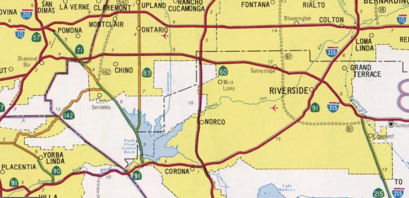
The 1935 Division of Highways Maps of San Bernardino County and Riverside County display in detail the early alignment of LRN 193. Within San Bernardino County, LRN 193 can be seen branching east from LRN 77 (California State Route 71) at the site of what is now the Prado Reservoir. LRN 193 followed modern McCarty Road, Cucamonga Avenue and Chino-Corona Road into Riverside County.


LRN 193 upon reentering San Bernardino County followed Armstrong Road and Cedar Avenue to LRN 26 (US Route 99/US Route 70 on Valley Boulevard) in Bloomington. From Bloomington, LRN 193 followed Bloomington Avenue and Riverside Avenue to LRN 9 (US Route 66 on Foothill Boulevard) in Rialto.

1935 Legislative Chapter 493 altered the definition and alignment of LRN 193. LRN 193 was now defined as beginning at LRN 43 (California State Route 18) in Corona and terminating at a northerly point at LRN 19.
The 1936 Division of Highways Map displays the new alignment and definition of LRN 193. LRN 193 is shown beginning in Corona and departing the city via Main Street. LRN 193 is displayed following Hamner Avenue and Milliken Avenue via Norco to a northern terminus at LRN 19.

1959 Legislative Chapter 1062 extended the definition of LRN 193 to LRN 31 (US Route 66-91-395 and Interstate 15) near Devore. The extended definition of LRN 193 first appears on the 1960 Division of Highways Map. The planned extension of LRN 193 north of US Route 60/LRN 19 is shown with an undetermined routing.


1962 Legislative Chapter 2089 defined LRN 30 as running from US Route 99-70/Interstate 10 at LRN 26 to US Route 66-91-395/Interstate 15 at LRN 31. The corridor of LRN 30 duplicated the already existing extension of LRN 193. LRN 30 had previously been used as part of the Oroville-Quincy Highway which served as early California State Route 24 before construction of the Feather River Highway.
The July/August 1962 California Highways & Public Works announced the California Highway Commission had adopted a planned alignment for the Devore Cutoff Freeway (LRN 193/LRN 30) during their June meeting. The Devore Cutoff Freeway began near Devore and extended south to Norco.


The November/December 1962 California Highways & Public Works announced LRN 193 was to be widened to four lanes along Hamner Avenue from Corona to near the Santa Ana River during the 1963-64 Fiscal Year.

LRN 193/LRN 30 appear on the 1963 Division of Highways Map with an adopted corridor between the vicinity of Devore south to Corona.


The July/August 1963 California Highways & Public Works announced the California Highway Commission had adopted an altered planned alignment for LRN 193 near Corona.

As part of the 1964 State Highway Renumbering LRN 193 and LRN 30 were reassigned as California State Route 31. California State Route 31 was defined as originating at Route 91 in Corona and terminating at Route 15 near Devore. California State Route 31 appears for the first time on the 1964 Division of Highways Map.



The November/December 1965 California Highways & Public Works announced the interchange between Interstate 15 and California State Route 31 was budgeted for construction during the 1967-68 Fiscal Year.

The 1969 Division of Highways Map displays California State Route 31 as being constructed from California State Route 60 north to Interstate 10 via Milliken Avenue.

The 1970 Division of Highways Map displays a portion of California State Route 31 and Devore Cutoff Freeway completed south from Interstate 15 to Cajon Boulevard.

During 1972 mainline Interstate 15 had been realigned onto the partially completed freeway corridors of California State Route 31 and California State Route 71 south of Corona. A letter from the California State Highway Engineer dated February 28, 1972, noted the request to shift the mainline corridor of Interstate 15 to California State Route 31 and California State Route 71 was submitted to the Federal Highway Administration during July 1971. The Federal Highway Administration approved the change of alignment for Interstate 15 on January 24, 1972. The new alignment of Interstate 15 was assigned as chargeable mileage.


1974 Legislative Chapter 537 rerouted Interstate 15 between Temecula and the San Bernardino area. Interstate 15 was realigned over what was the California State Route 31 along the planned freeway between San Bernardino and Corona. Interstate 15 south of Corona was realigned onto the partially constructed Corona Freeway corridor which had been built as California State Route 71. The original routing Interstate 15 between San Bernardino-Temecula was legislatively renumbered to California State Route 194 and signed as Interstate 15E.
California State Route 31 appears legislatively as Interstate 15 on the 1975 Caltrans Map.


The 1977 Caltrans Map depicts Interstate 15 being completed between Interstate 15E near Devore and Interstate 10. California State Route 31 is shown as still being signed between Interstate 10 and Corona. The segment of California State Route 31 south of Norco is shown to be co-signed as Interstate 15.


The last Caltrans Map to depict California State Route 31 was the 1979 edition. The 1981 Caltrans Map displays Interstate 15 completed south to California State Route 60. Temporary Interstate 15 is displayed as connecting south to Norco.

Interstate 15 south of California State Route 60 to Corona was completed during the late 1980s. The segment of Interstate 15 between Limonite Avenue north to the Interstate 215 interchange was named the "Ontario Freeway" by way of 1989 Assembly Concurrent Resolution 10, Chapter 136. The 1990 Caltrans Map displays completed Interstate 15 between California State Route 60 and Corona.
Comments