

Thanks to some good old ingenuity, one of the world's most unique bridges can be found connecting Bailey Island with Orr's Island across Will's Gut in Harpswell, Maine. The Bailey Island Bridge, also known as the Cribstone Bridge is located along Maine State Route 24 and was built to work with the flow of the tides in this area of coastal Maine. The bridge was built in 1928 and is believed to be the only one of its type in the world. Over the years, this bridge has weathered numerous hurricanes, strong tidal currents, ice, and constant contact with salt water that would ravage bridges made of steel and iron. Throughout its history, the bridge has been closed only once because of weather, when a severe southeast storm on January 9, 1978, with winds above 75 miles per hour and 50-year tides pushed the peak of the tides to over 13 feet. The bridge stood firm and functioned as designed, allowing the storm surge to flow through the structure without obstruction. As you may be able to tell, there is a method to the madness.
As early as the middle of the 19th Century, Bailey Island residents began to request that a bridge be built from Bailey Island to nearby Orr's Island, a distance of about 2,000 feet. During times of good weather, the residents could travel from one island to the other by boat. But in times of the year when the weather was more turbulent, it was nearly impossible to safely venture off of Bailey Island. For many years, the town of Harpswell turned down the request of the Bailey Island residents for a bridge to be built. But as the years went by, the state laws in Maine changed when a law came into effect allowing the state and counties to participate in funding for bridge projects, At a town meeting in October 1923, residents voted in favor of constructing a bridge to Bailey Island. Then, in 1926, a contract was signed for the construction of a new bridge to connect the two islands.
The Bailey Island Bridge was designed in concept by Dr. Llewellyn N. Edwards, the Maine State Bridge Engineer at the time, but the actual design layout was prepared by engineer Clarence L. Partridge. Frank W. Carlton of Woolwich, Maine was awarded the construction contract in May
1926. Construction occurred from June 1926 to September 1928 for $139,000. The bridge design presented some unique problems because of the tides in the area, so it was decided to build a crib bridge to allow the tides to ebb and flow through the bridge. This was similar to the design of a bridge found in Scotland, a bridge that is said to have been destroyed during World War II. The design specifies that a minimum of 30 percent void space must be provided through which waters may flow without obstruction, giving the bridge the ability to not restrict water movement.
To build the 1,167-foot-long bridge, granite was quarried from Pownal and North Yarmouth, Maine, then taken by wagon to Cousins River in Yarmouth, where the granite slabs were placed onto barges and shipped across Casco Bay to Bailey Island. The 12-foot rectangular granite slabs were sufficiently heavy enough to withstand action from wind and waves, and they rested upon the rock ledge on the surface. The slabs were dry laid and placed across the structure of the bridge in a crisscross lattice pattern, allowing for the bridge to be built without the use of mortar or cement. However, since some of the slabs were uneven, pine wedges were driven into the cracks between the granite slabs at certain places to prevent rocking and shifting from happening. Once everything was in place, a road surface was placed atop the slabs.
Over time, modest improvements were made to the Bailey Island Bridge. A sidewalk along the northbound side of the bridge was added in 1951, and a guardrail was added in 1962 for safety. But in the year 2000, after decades of inspections and continuous maintenance, officials determined that the Bailey Island Bridge required major repairs. After studies were completed, officials concluded that modest traffic volume would permit the rehabilitation and restoration of this unique bridge, instead of outright replacing the structure. The cribstone structure of the bridge had missing, shifted, cantilevered, and fractured stones, all of which needed attention during the rehabilitation process. As MaineDOT was committed to maintaining the unique granite substructure by the historic bridge management plan, they sought to replace as few stones as necessary and to match them with granite from the original quarry in Pownal whenever possible. A temporary bridge was built for use while rehabilitation took place between 2008 and 2010, then the Bailey Island Bridge was reopened for public use.
I have visited the Bailey Island Bridge on two occasions. The first time I thought I was crossing a neat bridge on my way to explore a bit of the island. But over time, I realized the historic and unique significance of the Bailey Island Bridge. I decided that I needed to make a return trip at some point to really spend time checking out the bridge and even to admire the problems that were solved with the design of this engineering marvel. I enjoyed walking around the bridge and seeing the detail that was put into making the Bailey Island Bridge one to last the test of time.
 |
| Found myself some rocks to walk around to see the Bailey Island Bridge from the side. |
 |
| And a little closer view of the bridge. |
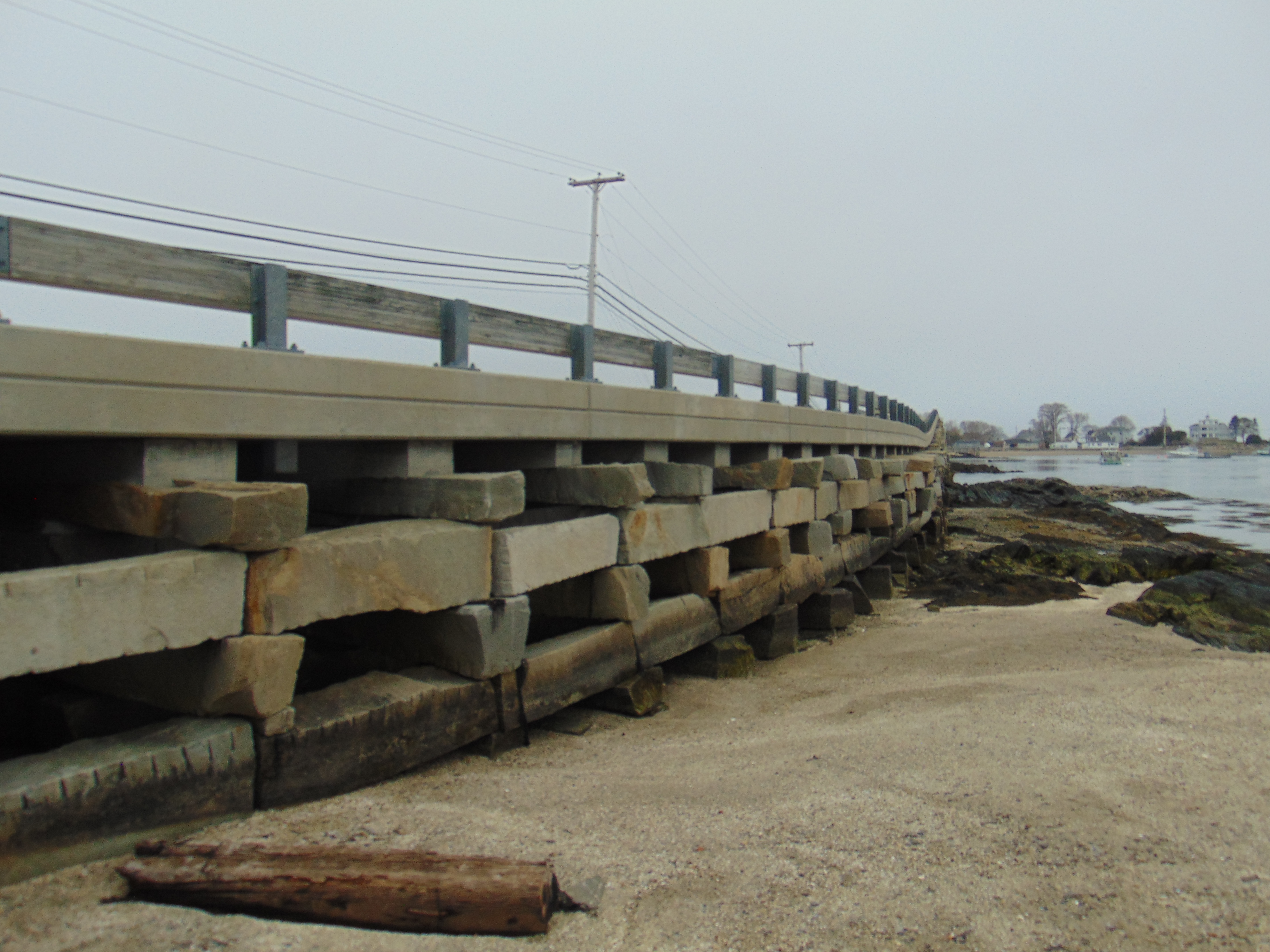 |
| The granite slabs really hold the bridge together. |
 |
| Now on the other side of the bridge. There is a main span of 52.5 feet in length in place to allow boats to pass under the bridge. |
 |
| I thought it would be nice to get an glimpse of how long the bridge is. |
 |
| Bridge plaque telling the story of how the Bailey Island Bridge works. |
 |
| The Bailey Island Bridge is a National Historic Civil Engineering Landmark. |
 |
| A close up of the inner workings of the bridge's cribstone design. |
 |
| On the top of the bridge. You can easily walk between Orr's Island and Bailey Island. |
 |
| Another shot of the seamy underbelly of the Bailey Island Bridge. |
 |
| Since it's Coastal Maine, why not get some photos of the local landscape. I parked my car near this house along the water to get photos of the bridge, but during my research, I found that another great place to get photos of the bridge is at Cooks Lobster House. |
 |
| And a parting shot before I head off to other places. |
How to Get There:
Sources and Links:
MaineDOT - Bailey Island Bridge, Harpswell, Maine
Town of Harpswell, Maine - Cribstone Bridge
HistoricBridges.org - Bailey Island Bridge
Maine Geological Survey - The Cribstone Bridge, Harpswell, ME
American Society of Civil Engineers - Bailey Island Bridge
Maine Preservation - Bailey Island Bridge, Harpswell
Harpswell, Maine Business Association - The Cribstone Bridge
Maine Magazine - Bailey Island Bridge
Comments