California State Route 187 is a five mile State Highway aligned Venice Boulevard located almost entirely within the city of Los Angeles. California State Route 187 begins at Interstate 10 Exit 7A and terminates at California State Route 1. California State Route 187 contains a deleted segment which once also included what is now Moomat Ahiko Way as part of the grade separation of Colorado Avenue in Santa Monica near Santa Monica Pier.
Part 1; the history of California State Route 187During 1933 the State removed the barriers which prevented the Division of Highways from maintaining mileage in incorporated cities. This measure led to a large influx of urban highways being added to the State Highway inventory during 1933. What would become California State Route 187 was added to the State Highway System as part of 1933 Legislative Chapter 767 as Legislative Route Number 163 (LRN 163). The original definition of LRN 163 was as follows:
"Continue Roosevelt Highway from the point where it intersects with Santa Monica Canyon Road at and it Santa Monica to a point where, if so continued, it would intersect Windward Avenue, in Venice, Los Angeles, California. Said road is now commonly known and designated as Ocean Front and parallels the Pacific Ocean a short distance therefrom."
The 1934 Division of Highways Map provides a simpler route description for LRN 163 which would be codified during 1935.
The 1934 Division of Highways Map displays unconstructed LRN 163 from LRN 60 in Santa Monica to Venice via Ocean Front. The alignment of LRN 60 is shown partially constructed aligning with planned LRN 163 towards the vicinity of Santa Monica Pier. LRN 60 is shown aligned through Santa Monica via a temporary alignment on Lincoln Boulevard.
The
1938 Division of Highway Map displays LRN 163 as an unconstructed highway between US Route 101A/LRN 60 in Santa Monica along the ocean to Venice in Los Angeles.
The
August 1939 California Highways & Public Works features a concept for Colorado Avenue Grade Separation which would include the first constructed segment of LRN 163. The Colorado Avenue Grade Separation project is stated to cooperative project between Public Works Administration and Division of Highways which would be built over the next nine months. The Colorado Avenue Grade Separation project is cited to have been designed out of a need to relieve traffic overflowing onto US Route 101A/LRN 60 in Santa Monica. LRN 163 would be constructed underneath Colorado Avenue (via what is now Moomat Ahiko Way) which would connect US Route 101A/LRN 60 to Ocean Avenue.
The
September 1940 California Highways & Public Works features the first constructed segment of LRN 163 underneath Santa Monica Pier and Colorado Avenue as part of the Santa Monica Grade Separation project. The Santa Monica Grade Separation is stated to have been completed on July 13th, 1940. Various pictures of US Route 101A/LRN 60 connecting to LRN 163 and Ocean Avenue are displayed.
The
1940 Division of Highways Map displays the complete Santa Monica Grade Separation and LRN 163 connecting US Route 101A to Ocean Avenue. LRN 163 is shown as an unconstructed highway south to Venice.
Very little development occurred with LRN 163 until the 1960s. During 1961 Legislative Chapter 1840 extended the definition of LRN 163 to a terminus at LRN 173 (planned Interstate 10 and the Santa Monica Freeway) via Pacific Avenue and Venice Boulevard. The extended definition of LRN 163 appears on the
1962 Division of Highways Map along with the unbuilt projected routing via Pacific Avenue and Venice Boulevard.
The Legislative Route Numbers were dropped during the 1964 State Highway Renumbering in favor of field signage. Legislative Routes Numbers which previously did not have a Sign State Route were assigned them as part of 1964 State Highway Renumbering. LRN 163 was subsequently assigned as California State Route 187 (CA 187). CA 187 retained the same definition as LRN 163 and first appears on the
1964 Division of Highways Map.
Thusly CA 187 appears on the
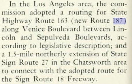
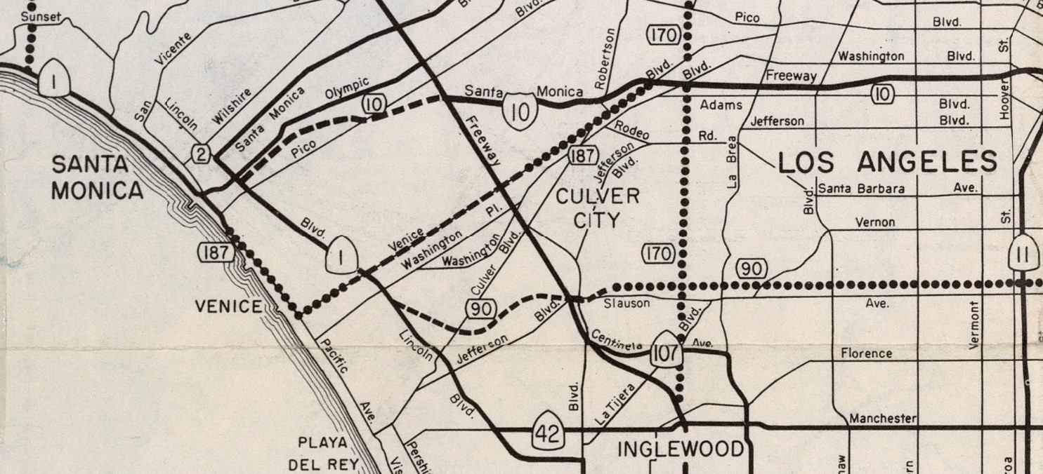
1965 Division of Highways Map with a planned routing on Venice Boulevard between CA 1/Lincoln Boulevard and Sepulveda Boulevard.
The
November/December 1965 California Highways & Public Works announced funding to reconstruct/widen Venice Boulevard as CA 187 from Sepulveda Boulevard to Interstate 10 during the 1966-67 Fiscal Year. The cost of widening Venice Boulevard as CA 187 is stated to be equally shared by the State and Los Angeles County.
The
1969 Division of Highways Map shows CA 187 constructed to State Standards on Venice Boulevard and Interstate 10. CA 187 is shown to be an unsigned highway with an unbuilt portion connecting Venice Boulevard to the existing segment in Santa Monica.
1988 Legislative Chapter 106 deleted and relinquished CA 187 in Santa Monica from the State Highway System. The route definition of CA 187 saw its western terminus definition changed to the south city limit of Santa Monica near Dewey Street. The deleted portion of CA 187 in Santa Monica does not appear on the
1990 Caltrans Map.
It is unclear when CA 187 was first signed but it did receive occasional reassurance shields on Venice Boulevard. CA 187 field signage became popular for sign theft due to it appearing on a Snoop Dog music album cover. This CA 187 shield was located at the intersection of CA 1/Lincoln Boulevard and Venice Boulevard. CA 187 theft was only accentuated by the number matching California Penal Code 187 which defined Statutory Murder.
1994 Assembly Bill 3132/Chapter 1220 deleted the unconstructed segment of CA 187 from the south city limit of Santa Monica CA 1/Lincoln Boulevard. This truncation defined CA 187 as existing on five miles of Venice Boulevard between CA 1 and Interstate 10. Oddly he western terminus of CA 187 is defined as Lincoln Boulevard and not CA 1. The current iteration of CA 187 appears on the
2005 Caltrans Map.
2015 Assembly Bill 810/Chapter 561 authorized the relinquishment of remaining CA 187 to the city of Los Angeles. During October 2016 the California Transportation Commission authorized the relinquishment of CA 187 to the city of Los Angeles. The relinquishment of CA 187 was contingent upon an agreement being reached on the value of CA 187/Venice Boulevard. CA 187 no longer appears as an active State Highway in the Caltrans Postmile Tool which indicates the relinquishment to Los Angeles as effective. Regardless of the relinquishment of CA 187 field signage remains sporadically in place.
Part 2; former California State Route 187 in Santa Monica
The vestige of CA 187 in Santa Monica is obvious as Colorado Avenue and the Santa Monica Pier sign are aligned over Moomat Ahiko Way.
Below former CA 187 on Moomat Ahiko Way can be seen branching from CA 1 southbound from atop Colorado Avenue.
Part 3; a drive on California State Route 187/Venice Boulevard
Westbound CA 187 begins from Interstate 10 Exit 7A in Los Angeles which empties onto Venice Boulevard. A guide sign on Interstate 10 indicates CA 187 as being present but there is no reassurance signage upon reaching Venice Boulevard.
CA 187/Venice Boulevard westbound between Interstate 10 and Interstate 405 rides the Los Angeles/Culver City line.
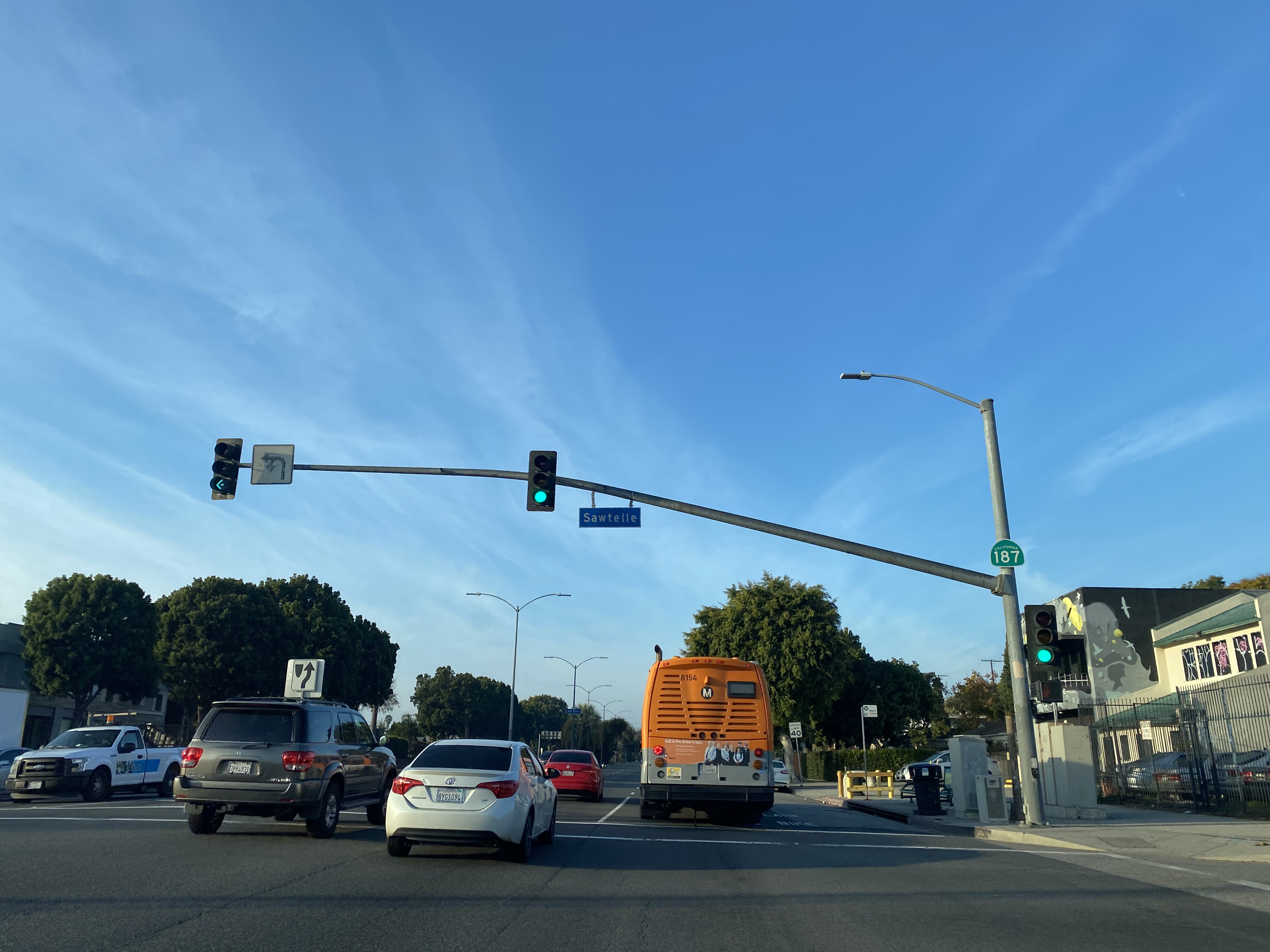
One CA 187 shield can be observed overhead on a street light assembly at Sawtelle Boulevard west of Interstate 405.
CA 187 westbound follows Venice Boulevard to an unsigned terminus at CA 1/Lincoln Boulevard.






Comments