California State Route 161 is a nineteen mile State Highway aligned along State Line Road between US Route 97 and California State Route 139. California State Route 161 bisects what remains of Lower Klamath Lake and is one of the easier ways to access Lava Beds National Monument. The entirety of California State Route 161 is part of the Volcanic Legacy Scenic Byway
Part 1; the history of California State Route 161
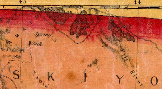
The development of modern California State Route 161 ("CA 161") is tied heavily to that of the Klamath Reclamation Project within the Klamath Basin. Historically Lower Klamath Lake and Tule Lake were an interconnected fresh water marsh fed by waters seeping from the Cascade Range. Lower Klamath Lake, Tule Lake and Clear Lake can be see seen obstructing direct overland access along the California/Oregon State Line on the 1873 Bancroft's Map of California and Nevada.
In 1905 the Federal Government announced it would fund the Klamath Reclamation Project which would drain much of the Klamath Basin for agricultural use. The A Canal was constructed during 1906 and began delivering diversions from the Klamath River and Upper Klamath Lake in 1907. The Southern Pacific Railroad plotted a line through the Klamath Basin in 1909 which tied many of the existing communities such as Klamath Falls and Merill. In 1910 Clear Lake Dam was completed which was followed by the Lost River Division Dam in 1912. Anderson-Rose Dam and the Link River dam was completed by 1921 which was followed by the Malone Division Dam on the Lost River in 1923. The early development of the Klamath Reclamation Project led to a population boom in the Klamath Basin which lasted until the onset of the Great Depression.
Klamath Basin can be seen on the 1924 Rand McNally Map of California and Oregon. Despite the infrastructure developments via the Klamath Reclamation Project the existing road network still had to diverge around Lower Klamath Lake and Tule Lake.
Tulelake was plotted in 1931 from a public land sale centered around the prospects of the expanding Klamath Reclamation Project in the southern Klamath Basin centered around Tule Lake. The lands reclaimed by the Klamath Reclamation Project greatly shrank Tule Lake and dried Lower Klamath Lake. The undeveloped expanse of the near empty Lower Klamath Lake and shrunken Tule Lake can be observed on the
1935 Division of Highways Map of Siskiyou County.
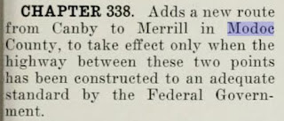
Given the proximity of Tulelake to the Southern Pacific Railroad coupled with the upcoming development of the new highway through Modoc National Forest the community grew large enough that it incorporated as a City on March 1st, 1937. During the late 1930s development of a highway through Modoc National Forest was undertaken by the Forest Service and Bureau of Public Roads. What became California State Route 139 ("CA 139") was brought into the State Highway System as part of
Legislative Route Number 210 ("LRN 210") as part of 1939 Legislative Chapter 338. The original definition of LRN 210 carried the following stipulation:
"near Canby to the Oregon State Line near Merrill" "to the state highway system, provided that the United States Government, through its agencies the Bureau of Public Roads and Forest Service construct or reconstruct with highway funds or any other funds made available by congress for highway purposes within the state of California."
LRN 210 and 1939 Legislative Chapter 338 is referenced in the October 1939 California Highways & Public Works. LRN 210 is described as a new highway under construction by the Federal Government in Modoc National Forest between Canby (US Route 299) north through Modoc County to the Oregon State Line near Merrill. This new highway was to be assumed by the California Division of Highways upon completion.
1943 California Legislative Chapter 964 repealed the 1939 stipulations of LRN 210 leaving only the route definition. This action was taken upon the completion of the new highway through Modoc National Forest which subsequently was turned over to the California Division of Highways. CA 139 appears for the first time on the 1944 Division of Highways Map aligned over LRN 210 from the Oregon State Line through Modoc National Forest to US Route 299 near Canby. The numbering of CA 139 seems to have been chosen to provide route continuity with OR 39. CA 39 was not available for use given it was among the original Sign State Routes defined in the August 1934 California Highways & Public Works. The completion of the new highway through Modoc National Forest by the Bureau of Public Roads likely was a priority during World War II due to the internment camp located at Tulelake.
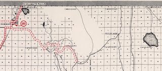
Despite CA 139/LRN 210 being developed east of Tulelake a east/west highway connecting it to Dorris at US Route 97/LRN 72 was still lacking. The empty expanse between Tulelake and Dorris is evident on the 1944 Division of Highways Map.
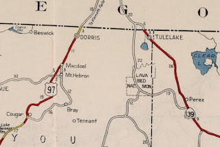
A Siskiyou County maintained roadway connecting Malone Road west to US 97/LRN 72 appears on the
1949 Division of Highways Map. The appearance of the "State Line Highway" indicated that it was completed during 1948.
State Line Highway is shown completed east of Malone Road to CA 139/LRN 210 on the
1957 Division of Highways Map which insinuated it was completed during 1956.

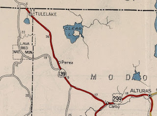
1959 Legislative Chapter 1062 added a second segment of
LRN 210 between Hatfield (immediately north of Tulelake) on the Oregon/California State Line west to US Route 97/LRN 72 near Dorris. The new segment of LRN 210 between Hatfield/Tulelake and Dorris on the California/Oregon State Line appears in the
November/December 1959 California Highways & Public Works. The State Line Highway between Tulelake and Dorris was mostly constructed in 1948 via funding of a 15.4 mile Federal Aid Secondary program. The remaining 3.8 miles of State Line Highway east of Malone Road is stated to straddle the California/Oregon State Line and wasn't finished until 1956. Much of State Line Highway was rebuilt west of Hatfield in 1958 which included a new bridge over the Lost River. State Line Highway was accepted for Division of Highways maintenance after meeting state standards on November 1st, 1959.

During the 1964 State Highway Renumbering the Legislative Route Numbers were dropped. What had been LRN 210 between Hatfield/Tulelake and Dorris was reassigned as CA 161. CA 161 appears for the first time on the
1964 Division of Highways State Map.
Part 2; a drive on California State Route 161
At Postmile SIS 5.022 CA 139 southbound intersects CA 161/State Line Road in the small rail siding community of Hatfield. Dorris is signed as being located 23 miles westward traversing CA 161 on State Line Road.
CA 161 crosses the Union Pacific Railroad in Hatfield immediately west of CA 139 and crosses the Lost River at Postmile SIS 19.23. CA 161 westbound is signed with a 65 MPH speed limit.
CA 161 westbound intersects Hill Road at Postmile SIS 17.30 in Ainsworth Corner. Hill Road is signed as access to Lava Beds National Monument and Tule Lake National Wildlife Refuge.
Lava Beds National Monument can visited by way of Hill Road south of CA 161. From Hill Road a vista of the western shore of Tule Lake can be observed. Modern Tule Lake is heavily regulated by the Klamath Project which essentially reshaped it into a square. Tule Lake became part of the Tule Lake National Wildlife Refuge in 1928.
Hill Road follows the western shore of Tule Lake into Lave Beds National Monument. Lava Beds National Monument was designated in 1925 and protects the largest lava fields within the Cascade Range. The lava beds come from the Medicine Lake Caldera which is about 30 miles northeast of Mount Shasta. The primary attraction in Lava Beds National Monument is the lava tubes ranging in age from 30,000 to 115,000.
Returning to CA 161 westbound the highway intersects Malone Road at Postmile SIS 17.20. Malone Road is signed as access to Merill, Oregon and Oregon Route 39.
As CA 161 west of Malone Road approaches US Route 97 it runs alongside the northern shore of what remains of Lower Klamath Lake.
CA 161 westbound terminates at US Route 97 four miles north of Dorris.


Comments