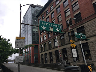
Former US Route 99 in Weed (US Route 97 and California State Route 265 on Weed Boulevard)


Weed Boulevard previously was the through segment of US Route 99 in downtown Weed of Siskiyou County, California.  Presently segments of former US Route 99 on Weed Boulevard are retained in the State Highway System as US Route 97 and California State Route 265. 

As noted above both US Route 97 ("US 97") and California State Route 265 ("CA 265") are aligned on former US 99 within the City of Weed on Weed Boulevard.  Approximately 0.430 miles of US 97 is aligned on Weed Boulevard along with 0.435 miles of CA 265.  The remaining 0.088 miles of CA 265 are aligned as access to Interstate 5 ("I-5") via Chaparral Drive.  Notably; US 97 and CA 265 on Weed Boulevard are also co-signed as Historic US 99 in addition to I-5 Business.  

This blog is part of the larger Gribblenation US Route 99 Page.  For more information pertaining to the other various segments of US Route 99 and it's three-digit child routes check out the link the below.


Part 1; the history of highways in the City of Weed

The City of Weed is named after after it's founder Abner Weed.  In the 19th Century Abner Weed noted that the winds near the present site of the City of Weed were especially good for drying lumber.  In 1897 Abner Weed purchased the Siskiyou Lumber & Mercantile Mill in addition to 280 acres of land where the City of Weed now stands.  The community of Weed was plotted along the Central Pacific Railroad Line between the communities of Edgewood and Mount Shasta City.  The lumber mill at Weed led to the community growing rapidly during the early 20th Century.  In 1961 Weed incorporated as a City. 

The emergence of the automobile in the early 20th Century in California led to the 1909 First State Highway Bond Act which was approved by voters during 1910.  The majority of the highways approved as part of the First State Highway Bond Act were largely well established routes of travel.  One such highway was Legislative Route Number 3 ("LRN 3") which was defined as a highway from "Sacramento to the Oregon Line."

By 1913 the Pacific Highway was created as a major Auto Trail between San Diego and Vancouver, British Columbia.  The Pacific Highway followed LRN 3 from the Oregon State Line south into downtown Red Bluff.  A very early LRN 3 from the Weed south to Redding can be seen on the 1917 California State Automobile Association Map.  Notably LRN 3 can be seen entering Weed via what is now Old Edgewood Road and Weed Boulevard. 

 
The initial draft of the US Route System was approved by the Secretary of Agriculture during November of 1925.  The US Route System with in California was approved by California Highway Commission with no changes recommended by January 1926.  The initial alignment of US 99 was largely planned to follow the Pacific Highway from the Oregon State Line south to Sacramento Valley.  US 99 is shown on a map published in the 1926 California Highways & Public Works following LRN 3 south from the Oregon State Line through Weed.


Thusly US 99 appears on the 1925 Rand McNally Map of California as being plotted on the LRN 3/Pacific Highway in Weed.


During November of 1926 the US Route System was approved by the AASHO.  US 99 can be seen aligned from Edgewood south on LRN 3 through Weed on the 1927 National Map Company Sectional Map. 


US 99/LRN 3 is shown shifted to what is now Edgewood Road north of Weed on the 1928 Division of Highways State Map.  It is likely US 99 was never signed on Old Edgewood Road and possible it was never part of the original alignment as I can't pin down an exact date for the relocation of LRN 3 to Edgewood Road.  Note; US Routes in California were not signed in any capacity prior to 1928.
 

Below is a custom drawn map showing what US 99 looked as it entered Weed via Edgewood Road and crossed through downtown via Weed Boulevard.  US 99 shows up on topographical maps south of downtown Weed over what is now the northbound lanes of I-5.  Notably the original interchange between US 99 and US 97 has been altered to direct traffic onto US 97 as the through route rather than modern CA 265.  

 
The State Legislature added LRN 72 to the State Highway System in 1931 according to CAhighways.org.  LRN 72 in it's original definition originated from US 99/LRN 3 at Weed Boulevard in downtown Weed and terminated at the Oregon State Line.  On June 23rd, 1934 the AASHO approved the shifting of US 97 from a terminus at US 99 near Ashland, Oregon to US 99/LRN 3 in Weed via LRN 72.  US 97 in California appears for the first time in the August 1934 California Highways & Public Works in an article announcing the Sign State Routes.  

The September/October 1951 California Highways & Public Works describes the opening of a new alignment of US 99/LRN 3 from the City of Weed 8 miles south to the vicinity of Mount Shasta City (specifically Spring Hill).  This new alignment of US 99/LRN 3 was much straighter than the original highway (built in 1923) and eliminated numerous curves between Weed-Mount Shasta City.  


The Federal Aid Highway Act was enacted on June 29th, 1956 which put US 99/LRN 3 through Weed on the planned route of I-5.  The November/December 1959 California Highways & Public Works discusses a planned freeway alignment of US 99/LRN 3 north of Weed 3.2 miles to the Shasta River.  The then present US 99/LRN 3 on Edgewood Road is described as curvy and difficult to plow in the winter.  


The 3.2 miles of US 99/LRN 3 freeway north of downtown Weed replacing Edgewood Road are shown as completed in the January/February 1963 California Highways & Public Works.  

During the 1964 State Highway Renumbering US 99/LRN 3 in Weed was redefined legislatively as Route 5 in anticipation of I-5 being completed.  US 99 appears on the 1964 Division of Highways State Map legislatively as Route 5 between Weed-Shasta Lake City.  

 
The AASHO Renumbering database shows that US 99 was approved to be truncated out of California by the AASHO Executive Committee on June 29th, 1965.  


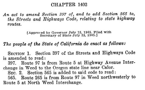
Thusly, California Legislative Chapter 1402 was approved by the Governor on July 15th, 1965.  Legislative Chapter 1402 extended US 97 south through downtown Weed via Weed Boulevard to the I-5 Highway Avenue Interchange.  Legislative Chapter 1402 also created CA 265 which was routed north from US 97 via Weed Boulevard to the North Weed Interchange of I-5. 
Despite the changes defined by 1965 Legislative Chapter 1402 I-5 still appears under construction in Weed on the 1966 Division of Highways Map.  It is likely US 97 and CA 265 on Weed Boulevard were signed as Temporary I-5. 

I-5 is shown to bypass downtown Weed via the current freeway on the 1967 Division of Highways Map. 


Part 2; a drive on former US Route 99 (current US Route 97 and California State Route 265) on Weed Boulevard

From I-5 northbound former US 99 on Weed Boulevard can be accessed via Exit 747 to US 97.  Approaching Exit 747 I-5 northbound traffic is notified that US 97 is also Historic US 99.  


US 97 traffic is advised Bend and Klamath Falls in Oregon are the primary Control Cities from Weed.  As US 97 begins it is co-signed with I-5 Business.  US 97 between I-5 Exit 747 and CA 265 on Weed Boulevard carries supplemental "L" suffixed Postmiles given it was extended after 1964.  


The Weed Souvenir Shop can be found at the corner of Weed Boulevard and Boise Street at US 97 Postmile SIS L0.144.  The Weed Souvenir Shop sells numerous trinkets which are popular with travelers who are entertained by the City Name.  


Who doesn't?

US 97 on Weed Boulevard carries numerous Historic US 99 shields.  

US 97 continues on Weed Boulevard until splitting away towards Oregon at the CA 265 junction at Postmile SIS L0.43.  North of CA 265 the Postmiles of US 97 reset to 0. 


As noted above Weed Boulevard has been altered in a way that makes US 97 the through route.  Weed Boulevard makes a left turn at US 97 Postmile SIS L0.43 onto CA 265.  CA 265 despite being a short highway is signed with numerous reassurance shields.  CA 265 begins with Postmile SIS 19.801 which is a relic of US 99 and was directly inherited from the 1964 Definition of Route 5.  CA 265 is also has numerous Historic US 99 shields. 


CA 265 continues north on Weed Boulevard to the northbound I-5 interchange at Postmile SIS 20.241 at the Edgewood Road intersection.  CA 265 turns left onto Chaparral Drive to the southbound ramp of I-5 where it terminates.  As noted in the custom map above originally US 99 softly transitioned as a through route onto Edgewood Road. 


Further Reading

Continuing north on US Route 99 to Yreka and the Shasta River Canyon? 


Continuing south on US Route 99 to Mount Shasta?


Comments

Unknown said…
This comment has been removed by the author.
Denis Fabbrini said…
Regarding when LRN 3 moved off of Old Edgewood Road to its new alignment, the USGS 1922 “Shasta Valley, Sheet No. 8” shows the newer Edgewood Road alignments.

Popular posts from this blog

The case to move Interstate 73 in Southern Ohio onto US 33

Every decade or so, Ohio pushes to revisit the proposed Interstate 73 that would connect Michigan to Myrtle Beach, South Carolina.  It's been happening since Congress legislated the route in 1991.  Within Ohio, Interstate 73 generally follows the US 23 corridor from Portsmouth through Columbus to Toledo, and into Michigan. Since High Priority Corridor Five was created , Ohio has really done nothing to move forward with Interstate 73.  Sure, there have been feasibility studies here and there.  But actual dollars and construction just haven't occurred. The US 33 Nelsonville Bypass appears to have been built to Interstate standards. However, Ohio has been slowly upgrading US 33 to a full freeway through Southeastern Ohio.  Bypasses of Lancaster and Nelsonville opened in 2004 and 2013, respectively.  Other sections of two-lane road are being twinned, some to freeway or, at a minimum, to expressway standards.  Currently, a $274 million widening project in...

Local Sign Find - The last remnant of Business Interstate 95 between Kenly and Rocky Mount , NC

As you head north on Interstate 95 at Exit 107 for Kenly and US 301, you'll notice something odd about the overhead sign for the exit.  Peeling off the sign for all that can see is the word 'NORTH' off-center from the US 301.  This old sign (probably close to original from when this section of I-95 opened - more on that in a little bit) gives a hint to a short-lived Business Interstate Route that ran from here to Rocky Mount. The last hint of the Kenly-Wilson-Rocky Mount Business I-95 (Shaun White - August 2020) Interstate 95 in North Carolina has a unique history.  But one of the overlooked and forgotten pieces of Interstate 95 in North Carolina is the 38 mile section between Kenly and Rocky Mount.  When opened to traffic in late 1978, it was the next to last piece of Interstate 95 in North Carolina to open replacing a four lane US 301 from Battleboro through Rocky Mount and Wilson to eventually tying back into the Interstate in Kenly. Though it was not delayed in l...

Nostalgia fast food with style - Returning to Rax

Nostalgia. It sells. It evokes, and more accurately, warps memories of days gone by.  Things were better, simpler, and we eat it up. Nostalgia can make you drive three hours and over a hundred miles out of your way just to reconnect with a dying fast-food restaurant you last enjoyed in the early to mid-90s.  That person was me - that restaurant was Rax. I could go on about Rax's history, but in short, Rax was briefly a very popular roast beef fast-food chain.  Growing up in the 80s and early 90s in Western PA, Rax was the good fast-food spot.  The milkshakes.  (Personally, the chocolate chip milkshake was heaven.)  Uncle Alligator Kids Meal with the chocolate chip cookie. Take that McDonald's Happy Meal!  The fancy salad and hot foods bar.  Going to Rax was special.  Like so many similar restaurants, various investments, management decisions, etc., led Rax to almost disappear overnight.  By the time I graduated college in late 1999, abou...