Being one of the more scenic states in the United States, Colorado is loaded with beautiful scenery and the impressive Rocky Mountains. During my visit to Colorado, I wanted to take in as much as the state had to offer in what little time I had. Fortunately, I was able to see some pretty amazing drives and mountain passes along the way.
One place I was able to check out was Independence Pass, which is on Colorado State Highway 82 south of
Leadville, which has the highest elevation of any incorporated city in the United States at 10,152 feet above sea level, and
Aspen, which is renowned for its skiing opportunities. This road is part of the
Top of the Rockies Scenic Byway as well, passing scenic alpine meadows, mountain streams, aspen forests and even
Mount Elbert, Colorado's highest mountain at 14,433 feet above sea level. A trip up Independence Pass will take you high above the Rockies, and at 12,095 feet above sea level, it is the highest paved mountain pass in Colorado. But be aware that the road is only open to motor vehicles between just before Memorial Day weekend and the beginning of November, and it is closed the rest of the year due to snow. However, there is a bike ride and race called
Ride for the Pass, which takes place the weekend before CO 82 is open to the public each May. My own visit was the weekend after Memorial Day weekend, and there was still plenty of snow along the road then.
So let's take a drive along this wonderful road...
 |
| Turning right onto CO 82 from US 24. We're not far from US 24's western terminus, but we are far, far away from some of the cities and states that US 24 also serves, such as Colorado Springs, Kansas City and Detroit, Michigan metropolitan area. |
 |
| We'll be focusing on the drive on CO 82 between US 24 and Aspen. The mountains are already in view, and we are in some alpine tundra or high desert terrain. |
 |
| The mountains are in view at Twin Lakes, which are two glacial fed lakes that CO 82 passes near. Right now we are at about 9100 feet above sea level in the upper reaches of the upper Arkansas River Valley. While the Twin Lakes are fed by a tributary of the Arkansas River, the Arkansas River has its source near Leadville and winds its way through Colorado, Kansas, Oklahoma and Arkansas before ending at the Mississippi River. |
 |
| You will start to see the hills along the road rise up to Colorado's highest peak Mount Elbert, along with Mount Massive to its north. You may also spot La Plata Peak, the fifth tallest mountain in Colorado, along with several other summits in view that also top 13,000 feet. |
 |
| But until then, let's just enjoy the mountain scenery. |
 |
| East of the pass, the aspen trees have yet to bloom, and this is on May 31. |
 |
| Heading into a forested canyon. You may spot a few houses or a campsite along the way. |
 |
| A scenic alpine stream. |
 |
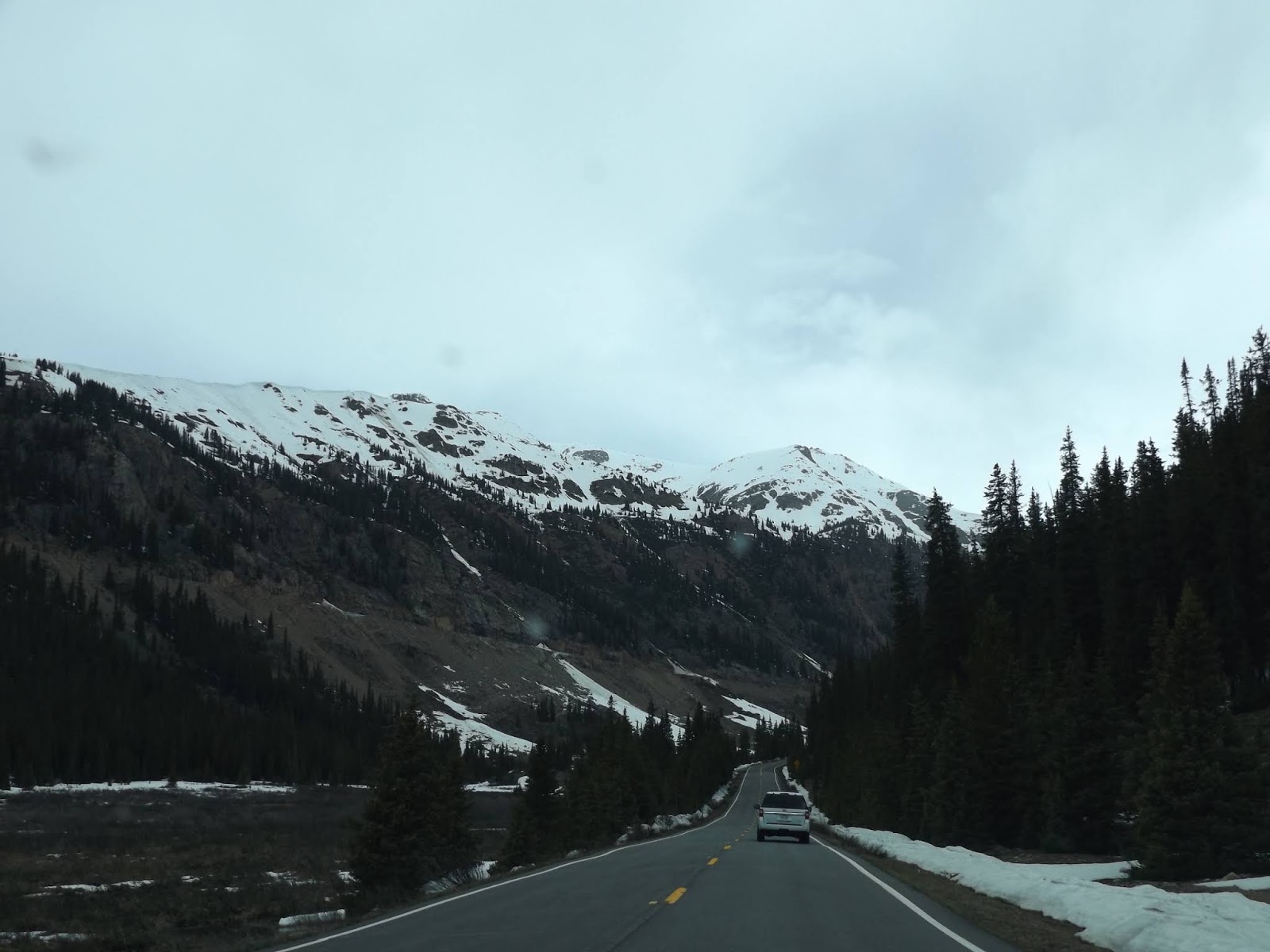
| Some snow to go with your hillsides. |
 |
| Here, you will start to climb up the ascent to Independence Pass, and it can be steep at times. There are a number of switchbacks to contend with, as you climb up 1300 feet in elevation over the course of 4 miles to the crest of the Sawatch Range and the pass itself. |
 |
| Plus, there is plenty more mountain scenery to admire. |
 |
| And you begin to see some snow pushed on the side of the road that has not melted yet. |
 |
| Love that mountain scenery, don't love the dirty snow on the side of the pullout, though. |
 |
| If you look around carefully, you have already made quite the ascent! Keep going for more refreshing Rocky Mountain scenery. |
 |
| But be careful. You are surrounded by rocky cliffs, a steep drop and other cars. No wonder why CO 82 is closed to Independence Pass in winter. |
 |
| The 30 mile an hour speed limit is certainly justified here. This is a highly technical stretch of road. |
 |
High up in the Rockies, it is still winter.
Crossing the county line into Pitkin County, just before Independence Pass. |
|
 |
| Independence Pass. It is a beautiful view all around you from the mountain pass. |
 |
| At an elevation of 12,095 feet above sea level, Independence Pass is the highest paved mountain pass in Colorado, and it crosses the Continental Divide as well. There are no visitor facilities at the pass, just a parking area and a short path leading to two overlooks of Lake Creek valley and surrounding peaks. A longer trail is also here, which heads southwest and follows the Continental Divide to an unnamed peak 700 feet higher up in elevation. The day before, I crossed Loveland Pass, which is further north and east closer to Denver, and that mountain pass only tops out at 11,990 feet above sea level. The boundary between the White River and San Isabel National Forests is also here. |
 |
| Some brief snow frolicking and general admiration of the snow capped mountains. The land around the pass is flat and is alpine tundra when not covered by snow. The tree line is a thousand feet lower down. |
 |
| CO 82 at Independence Pass. |
 |
| Starting to make my descent west from Independence Pass and eventually to Aspen, which is about 20 miles west of the pass. On the way to Aspen, you will encounter various campsites, trailheads, the Independence ghost town, the Grottos Ice Cave. |
 |
| The scenery going west is just as nice as it was coming from the east. Be on the lookout for switchbacks and other hairpin turns along the way as well. |
 |
| The tall poles along the road are useful when it comes to high snow amounts. |
 |
| A rock wall along the north side of the road. |
 |
| Starting to see some evergreen forests, but the snow capped peaks still remain in the distance. |
 |
| The Lost Man Trailhead. |
 |
| Some dark clouds ahead. I will be encountering that rain a little down the road. |
 |
| But before then, let's drive through a nifty canyon. |
 |
| Here comes the rain. |
 |
| But on the other side of the rain, it looks like the trees are in bloom. |
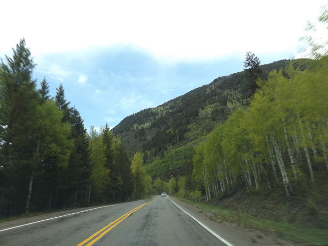 |
| And it's spring! |
 |
| Aspen is beautiful. |
 |
| Aspen is also where our story ends. There is skiing to be found in Aspen during the winter,but it looks like the snow is mostly a memory at this point. CO 82 continues west through some beautiful countryside and red sandstone cliffs on its way to Snowmass, Basalt and eventually I-70 in Glenwood Springs. |
How to Get There:
Sources and Links:
Aspen Chamber Resort Association -
Independence Pass
Aspen Chamber Resort Association -
Everything You Need To Know About Independence Pass
The American Southwest -
Independence Pass
Colorado Department of Transportation -
Independence Pass Travel Information
Leadville Twin Lakes -
Scenic Byways

 One place I was able to check out was Independence Pass, which is on Colorado State Highway 82 south of Leadville, which has the highest elevation of any incorporated city in the United States at 10,152 feet above sea level, and Aspen, which is renowned for its skiing opportunities. This road is part of the Top of the Rockies Scenic Byway as well, passing scenic alpine meadows, mountain streams, aspen forests and even Mount Elbert, Colorado's highest mountain at 14,433 feet above sea level. A trip up Independence Pass will take you high above the Rockies, and at 12,095 feet above sea level, it is the highest paved mountain pass in Colorado. But be aware that the road is only open to motor vehicles between just before Memorial Day weekend and the beginning of November, and it is closed the rest of the year due to snow. However, there is a bike ride and race called Ride for the Pass, which takes place the weekend before CO 82 is open to the public each May. My own visit was the weekend after Memorial Day weekend, and there was still plenty of snow along the road then.


Comments