After reaching the western terminus of US Route 212 I entered Yellowstone National Park from the Northeast Entrance Station.

This blog serves as Part 15 of the 2016 Summer Mountain Trip Series; Part 14 can be found here:
2016 Summer Mountain Trip Part 14; US Route 212 over the Beartooth Highway
Yellowstone National Park is the oldest National Park in the United States having been signed into law by President Ulysses S. Grant in 1872. Yellowstone National Park consists of land located on the Yellowstone Caldera mostly in Wyoming but also in parts of Montana and Idaho as well.
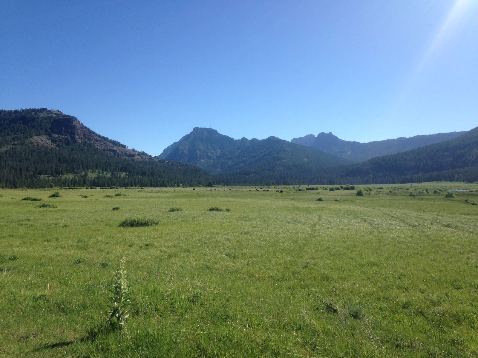
Contrary to what Google Maps might tell you, the US Routes cease to exist within Yellowstone National Park. Yellowstone instead is traversed by a series of roadways maintained by the National Park Service, many which actually shutter in the winter months. The Northeast Entrance Road begins at the west terminus of US Route 212 and follows the Lamar River to the Grand Loop Road at the confluence with the Yellowstone River. The Lamar River apparently is one of the best places in all of Yellowstone to find wandering herds of Buffalo.


It isn't uncommon to see all sorts of animals along the waterways of Yellowstone.

At Tower Junction the Northeast Entrance Road crosses the Yellowstone River and meets the Grand Loop Road which circles almost all of Yellowstone National Park. I turned south on the Grand Loop Road from Tower Junction.


On the Grand Loop Road heading southbound there are some scenic views of the Yellowstone River at Devil's Den as it descends from Yellowstone Lake through the northern extent of the Grand Canyon of the Yellowstone.


Tower Fall along Tower Creek can be observed from Devil's Den.

The Grand Loop Road ascends over the 8,859 foot Dunraven Pass near Mount Washburn which provides a wide vista of the surrounding terrain. The summit of Mount Washburn lies at 10,243 feet above sea level.


At Canyon Junction I pulled off the Grand Loop Road on to Rim Drive above the Grand Canyon of the Yellowstone. Rim Drive provides access to the vistas above the Grand Canyon of the Yellowstone. The 109 foot high Upper Yellowstone Falls can be observed from Rim Drive.


I parked my car along Rim Drive and ran the rest of the way to the overlooks. I first made my way to the top of Lower Yellowstone Falls.


From the bottom of Yellowstone Falls the full 308 foot drop can be easily observed.


From Canyon Junction I turned west on Norris Canyon Road to take a shortcut towards the western part of the Grand Loop Road. Upon reaching Grand Loop Road again I turned south towards Old Faithful and stopped at Gibbon Falls located on the Gibbon River.

Near Madison Junction the Grand Loop Road follows the Firehole River southward. I stopped briefly on the Fountain Paint Pot Trail to see the geyser basin.


One of the main attractions on the western segment of Grand Loop Road is Grand Prismatic Spring. Grand Prismatic Springs is the largest hot spring in Yellowstone and the third largest in the world. The strange colors come from microbes which produce the effect near the rim of the 370 foot diameter hot spring. Grand Prismatic Spring is 160 feet deep and the clear blue color is endemic of the sterile environment. Grand Prismatic Spring has a temperature apparently close to 160F.

The Opal Pool, Turqoise Pool, and Excelsior Pool are located within the vicinity of Grand Prismatic Spring.


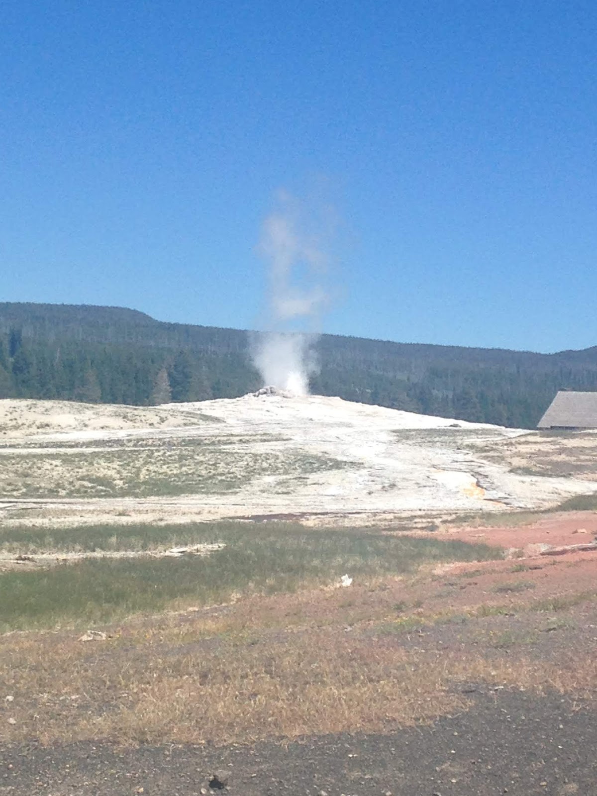
At the very bottom of Grand Loop Road is the Upper Geyser Basin. The Old Faithful Geyser is a well known and highly predictable geyser which was first discovered in 1870. Old Faithful erupts on average every 90 minutes at heights generally ranging from about 106 to 185 feet. The Old Faithful Geyser seems to be relatively predictable in nature due to it not being tied to any other feature in Upper Geyser Basin. The steam erupting from Old Faithful generally ranges from 240F to 265F.


At West Thumb I stopped briefly at Yellowstone Lake before heading south out of Yellowstone National Park on South Entrance Road. Yellowstone Lake is the largest freshwater lake in the United States above 7,000 feet at approximately 136 square miles. Yellowstone Lake isn't especially deep which causes it's surface to freeze mostly over in the winter months. The primary inflow and outflow of Yellowstone Lake is the Yellowstone River.

South Entrance Road follows the Lewis River to the confluence with the Snake River at the boundary of Grand Teton National Park. South Entrance Road becomes John D. Rockerfeller Parkway in Grand Teton National Park.
Part 16 of this blog series can be found here:
2016 Summer Mountain Trip Part 16; Grand Teton National Park and the nebulous disconnect in the US Routes

This blog serves as Part 15 of the 2016 Summer Mountain Trip Series; Part 14 can be found here:
2016 Summer Mountain Trip Part 14; US Route 212 over the Beartooth Highway
Yellowstone National Park is the oldest National Park in the United States having been signed into law by President Ulysses S. Grant in 1872. Yellowstone National Park consists of land located on the Yellowstone Caldera mostly in Wyoming but also in parts of Montana and Idaho as well.
Contrary to what Google Maps might tell you, the US Routes cease to exist within Yellowstone National Park. Yellowstone instead is traversed by a series of roadways maintained by the National Park Service, many which actually shutter in the winter months. The Northeast Entrance Road begins at the west terminus of US Route 212 and follows the Lamar River to the Grand Loop Road at the confluence with the Yellowstone River. The Lamar River apparently is one of the best places in all of Yellowstone to find wandering herds of Buffalo.


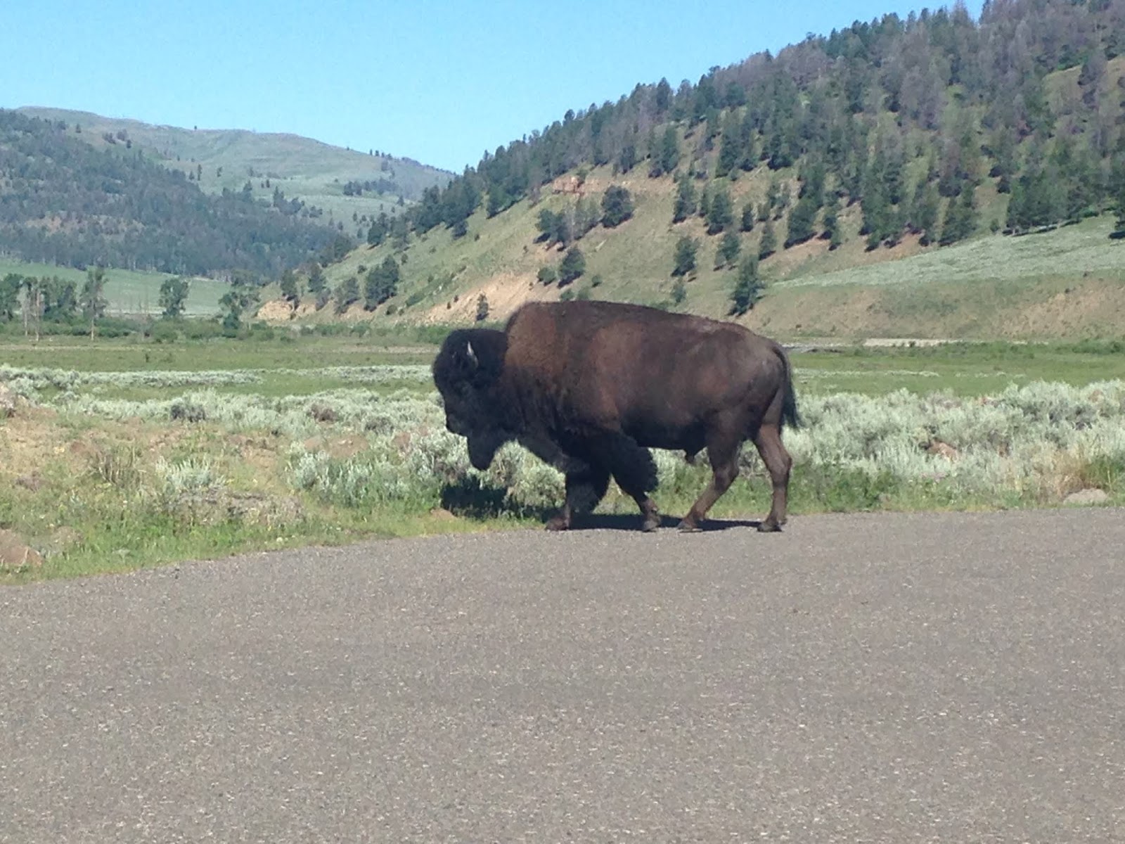
It isn't uncommon to see all sorts of animals along the waterways of Yellowstone.

At Tower Junction the Northeast Entrance Road crosses the Yellowstone River and meets the Grand Loop Road which circles almost all of Yellowstone National Park. I turned south on the Grand Loop Road from Tower Junction.


On the Grand Loop Road heading southbound there are some scenic views of the Yellowstone River at Devil's Den as it descends from Yellowstone Lake through the northern extent of the Grand Canyon of the Yellowstone.


Tower Fall along Tower Creek can be observed from Devil's Den.

The Grand Loop Road ascends over the 8,859 foot Dunraven Pass near Mount Washburn which provides a wide vista of the surrounding terrain. The summit of Mount Washburn lies at 10,243 feet above sea level.


At Canyon Junction I pulled off the Grand Loop Road on to Rim Drive above the Grand Canyon of the Yellowstone. Rim Drive provides access to the vistas above the Grand Canyon of the Yellowstone. The 109 foot high Upper Yellowstone Falls can be observed from Rim Drive.


I parked my car along Rim Drive and ran the rest of the way to the overlooks. I first made my way to the top of Lower Yellowstone Falls.


From the bottom of Yellowstone Falls the full 308 foot drop can be easily observed.


From Canyon Junction I turned west on Norris Canyon Road to take a shortcut towards the western part of the Grand Loop Road. Upon reaching Grand Loop Road again I turned south towards Old Faithful and stopped at Gibbon Falls located on the Gibbon River.

Near Madison Junction the Grand Loop Road follows the Firehole River southward. I stopped briefly on the Fountain Paint Pot Trail to see the geyser basin.


One of the main attractions on the western segment of Grand Loop Road is Grand Prismatic Spring. Grand Prismatic Springs is the largest hot spring in Yellowstone and the third largest in the world. The strange colors come from microbes which produce the effect near the rim of the 370 foot diameter hot spring. Grand Prismatic Spring is 160 feet deep and the clear blue color is endemic of the sterile environment. Grand Prismatic Spring has a temperature apparently close to 160F.

The Opal Pool, Turqoise Pool, and Excelsior Pool are located within the vicinity of Grand Prismatic Spring.


At the very bottom of Grand Loop Road is the Upper Geyser Basin. The Old Faithful Geyser is a well known and highly predictable geyser which was first discovered in 1870. Old Faithful erupts on average every 90 minutes at heights generally ranging from about 106 to 185 feet. The Old Faithful Geyser seems to be relatively predictable in nature due to it not being tied to any other feature in Upper Geyser Basin. The steam erupting from Old Faithful generally ranges from 240F to 265F.


At West Thumb I stopped briefly at Yellowstone Lake before heading south out of Yellowstone National Park on South Entrance Road. Yellowstone Lake is the largest freshwater lake in the United States above 7,000 feet at approximately 136 square miles. Yellowstone Lake isn't especially deep which causes it's surface to freeze mostly over in the winter months. The primary inflow and outflow of Yellowstone Lake is the Yellowstone River.

South Entrance Road follows the Lewis River to the confluence with the Snake River at the boundary of Grand Teton National Park. South Entrance Road becomes John D. Rockerfeller Parkway in Grand Teton National Park.
Part 16 of this blog series can be found here:
2016 Summer Mountain Trip Part 16; Grand Teton National Park and the nebulous disconnect in the US Routes
Comments