After leaving the Marin Headlands I crossed the Golden Gate Bridge into San Francisco. My hotel was strategically located at intersection of Lombard Street and Van Ness Avenue where US 101 just so happens to turn south. I tend to select hotels near Lombard and Van Ness due to the ease of walking to places like Russian Hill, Fisherman's Wharf, and the San Francisco Maritime National Historical Park. A quick walk across the street afforded an eastbound uphill view of Lombard Street ascending Russian Hill.

Russian Hill is one of more than forty named hills in San Francisco. Essentially the street grid of San Francisco was basically just layered over street hills with grades sometimes exceeding 20%. The most obvious feature of Russian Hill is Lombard Street which is largely known for curvy one-way alignment east of Hyde Street to Leavenworth Street. Between Van Ness Avenue and Hyde Street the alignment of Lombard Street is two-way and requires 90 degree parking due to the steep grade.


San Francisco is littered with early 20th century Art Deco buildings that were largely built after the 1906 Earthquake. There is all sorts of random things to see just walking around like this old police telephone on Lombard Street and Larkin Street.

Lombard Street and Hyde Street is the intersection at the top of the infamous Lombard Street twisties. Lombard Street is often called the most curvy street in the world but that claim is somewhat debatable given that Vermont Street in San Francisco is often cited with the same claim. The reported grade of Lombard Street with the curves is apparently 27% which obviously wasn't adequate for urban automotive traffic. The eight curves on Lombard Street were built in 1922 and apparently add about 190 feet to the length between Hyde Street east to Leavenworth Street. Starting from the top there is a nice easterly view of Treasure Island, the Bay Bridge, and Colt Tower.


After descending Lombard Street I had dinner in Fisherman's Wharf which was near the Hyde Street Pier. The Hyde Street Pier is the landing location for traffic using US 101 south prior to the completion of the Golden Gate Bridge. The Golden Gate Bridge opened for traffic in May of 1937 meaning that traffic was forced to use the Ferry from Sausalito along US 101 when the US Route system was created in 1926.

The Hyde Street Pier is now managed by the National Park Service as part of the San Francisco Maritime National Historic Park. I'm not sure of the vintage of this US 101 shield but it is a nice touch with the Redwood Highway in the crown.

Understanding the alignments of US Routes in San Francisco is an odd one. Before 1933 the California Divisions of Highways apparently didn't even maintain any highways in the city limits of San Francisco. Trying to track down old maps of the city showing a clear alignment of US 101 prior the completion of Golden Gate Bridge is difficult given it was on city maintained streets. Back in the 1930s it wasn't uncommon even for state routes to be signed on non-state maintained roadway, the practice seems to have stopped by the end of the 1930s. The 1938 State Highway Map shows certain routes like CA 180, 33, and 49 partially on county or locally maintained roadways. Those roadways not maintained by the state are not shown as state highways by 1940.
1938 State Highway Map
1940 State Highway Map
So with that all in mind I've never seen a conclusive document showing a clear alignment of any US Route in San Francisco prior to 1937. That being the case I'll try to decipher the history of US Routes prior to the Bay Area Bridges being completed. Starting with US 101 I suspect that traffic heading south off of the Hyde Street Pier continued on Hyde and took a westward turn on Bay Street to Van Ness Avenue. The 1933 Goshua City Map Insert (courtsey of a link provided by USends.com) and the 1934 State Highway Map City insert show a major but yet unsigned route along those roads to the Hyde Street Pier.
1933 Bay Area City Insert
1934 State Highway Map City Insert
Of course that really doesn't explain the whole alignment history of when US 101 was split into US 101W and US 101E. Prior to 1929 US 101 was a stand alone route on the San Francisco side of the Bay before it split into dual routes. The original US 101 became US 101W while a new route from the ferries in Oakland was carved out of part of US 48 to become US 101E. USends has a map on the page about endpoints in San Francisco showing the split in US 101.
USends on San Francisco US Route end points
It would seem by at least 1936 US 101W was reconsolidated into mainline US 101 on the San Francisco side of the Bay while US 101E was partially absorbed by US 50 which was extended west from Hayward. US 40 and 50 were was officially routed into San Francisco in 1936 via the newly completed Bay Bridge as well.
1936 State Highway Map
1936 State Highway Map City Insert
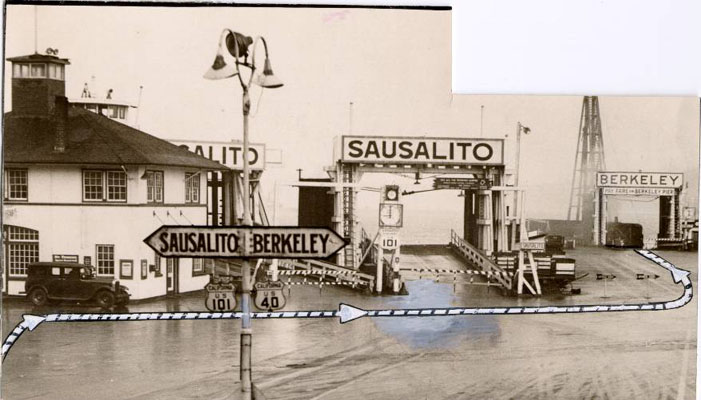
Regarding US 40 it seems that it was co-signed at the Hyde Street Pier along US 101. This photo of the Hyde Street Pier shows traffic being directed to board to the ferry for Berkeley.
Early Hyde Pier Photo
As I mentioned previously the roadways in San Francisco were city all city maintained until likely 1933 when the Golden Gate Bridge and Bay Bridge construction projects began. By 1935 there are clearly state maintained roadways shown on the California Divisions of Highway Map of San Francisco prior to the completion of the bridges.
1935 California Division of Highways City of San Francisco Map
Highway history aside the Hyde Street Pier has numerous ship and ferry exhibits that are worth a look.


Nice view of Alcatraz from the Eureka.

To close out the night I headed over Municipal Pier next to Fort Mason to close out the night viewing sun down over the Golden Gate.


Walking to the hotel I spotted a warning bill unique to San Francisco. I would imagine this isn't what you want to see posted on the building where you live.

Sunday morning I had a somewhat early start near sunrise and left the hotel following US 101 south on Van Ness Avenue. There seems to be a some sort of public transit project underway which had automotive traffic bisecting Van Ness in places.


Van Ness and US 101 pass by the 1915 San Francisco City Hall which was a replacement for the prior building which burned in the 1906 Earthquake.


I followed US 101 south on Van Ness to the Central Freeway. The Central Freeway originally extended north from where it currently ends at Market Street. The northbound lanes of the Central Freeway ended at Golden Gate Avenue and Franklin Street while the southbound lanes started at Turk Street and Gough Street. The 1989 Loma Prieta/World Series Earthquake damaged the northern segment of the Central Freeway beyond repair which required US 101 be rerouted.


Russian Hill is one of more than forty named hills in San Francisco. Essentially the street grid of San Francisco was basically just layered over street hills with grades sometimes exceeding 20%. The most obvious feature of Russian Hill is Lombard Street which is largely known for curvy one-way alignment east of Hyde Street to Leavenworth Street. Between Van Ness Avenue and Hyde Street the alignment of Lombard Street is two-way and requires 90 degree parking due to the steep grade.


San Francisco is littered with early 20th century Art Deco buildings that were largely built after the 1906 Earthquake. There is all sorts of random things to see just walking around like this old police telephone on Lombard Street and Larkin Street.

Lombard Street and Hyde Street is the intersection at the top of the infamous Lombard Street twisties. Lombard Street is often called the most curvy street in the world but that claim is somewhat debatable given that Vermont Street in San Francisco is often cited with the same claim. The reported grade of Lombard Street with the curves is apparently 27% which obviously wasn't adequate for urban automotive traffic. The eight curves on Lombard Street were built in 1922 and apparently add about 190 feet to the length between Hyde Street east to Leavenworth Street. Starting from the top there is a nice easterly view of Treasure Island, the Bay Bridge, and Colt Tower.


After descending Lombard Street I had dinner in Fisherman's Wharf which was near the Hyde Street Pier. The Hyde Street Pier is the landing location for traffic using US 101 south prior to the completion of the Golden Gate Bridge. The Golden Gate Bridge opened for traffic in May of 1937 meaning that traffic was forced to use the Ferry from Sausalito along US 101 when the US Route system was created in 1926.

The Hyde Street Pier is now managed by the National Park Service as part of the San Francisco Maritime National Historic Park. I'm not sure of the vintage of this US 101 shield but it is a nice touch with the Redwood Highway in the crown.

Understanding the alignments of US Routes in San Francisco is an odd one. Before 1933 the California Divisions of Highways apparently didn't even maintain any highways in the city limits of San Francisco. Trying to track down old maps of the city showing a clear alignment of US 101 prior the completion of Golden Gate Bridge is difficult given it was on city maintained streets. Back in the 1930s it wasn't uncommon even for state routes to be signed on non-state maintained roadway, the practice seems to have stopped by the end of the 1930s. The 1938 State Highway Map shows certain routes like CA 180, 33, and 49 partially on county or locally maintained roadways. Those roadways not maintained by the state are not shown as state highways by 1940.
1938 State Highway Map
1940 State Highway Map
So with that all in mind I've never seen a conclusive document showing a clear alignment of any US Route in San Francisco prior to 1937. That being the case I'll try to decipher the history of US Routes prior to the Bay Area Bridges being completed. Starting with US 101 I suspect that traffic heading south off of the Hyde Street Pier continued on Hyde and took a westward turn on Bay Street to Van Ness Avenue. The 1933 Goshua City Map Insert (courtsey of a link provided by USends.com) and the 1934 State Highway Map City insert show a major but yet unsigned route along those roads to the Hyde Street Pier.
1933 Bay Area City Insert
1934 State Highway Map City Insert
Of course that really doesn't explain the whole alignment history of when US 101 was split into US 101W and US 101E. Prior to 1929 US 101 was a stand alone route on the San Francisco side of the Bay before it split into dual routes. The original US 101 became US 101W while a new route from the ferries in Oakland was carved out of part of US 48 to become US 101E. USends has a map on the page about endpoints in San Francisco showing the split in US 101.
USends on San Francisco US Route end points
It would seem by at least 1936 US 101W was reconsolidated into mainline US 101 on the San Francisco side of the Bay while US 101E was partially absorbed by US 50 which was extended west from Hayward. US 40 and 50 were was officially routed into San Francisco in 1936 via the newly completed Bay Bridge as well.
1936 State Highway Map
1936 State Highway Map City Insert
Regarding US 40 it seems that it was co-signed at the Hyde Street Pier along US 101. This photo of the Hyde Street Pier shows traffic being directed to board to the ferry for Berkeley.
Early Hyde Pier Photo
As I mentioned previously the roadways in San Francisco were city all city maintained until likely 1933 when the Golden Gate Bridge and Bay Bridge construction projects began. By 1935 there are clearly state maintained roadways shown on the California Divisions of Highway Map of San Francisco prior to the completion of the bridges.
1935 California Division of Highways City of San Francisco Map
Highway history aside the Hyde Street Pier has numerous ship and ferry exhibits that are worth a look.


Nice view of Alcatraz from the Eureka.

To close out the night I headed over Municipal Pier next to Fort Mason to close out the night viewing sun down over the Golden Gate.


Walking to the hotel I spotted a warning bill unique to San Francisco. I would imagine this isn't what you want to see posted on the building where you live.

Sunday morning I had a somewhat early start near sunrise and left the hotel following US 101 south on Van Ness Avenue. There seems to be a some sort of public transit project underway which had automotive traffic bisecting Van Ness in places.


Van Ness and US 101 pass by the 1915 San Francisco City Hall which was a replacement for the prior building which burned in the 1906 Earthquake.


I followed US 101 south on Van Ness to the Central Freeway. The Central Freeway originally extended north from where it currently ends at Market Street. The northbound lanes of the Central Freeway ended at Golden Gate Avenue and Franklin Street while the southbound lanes started at Turk Street and Gough Street. The 1989 Loma Prieta/World Series Earthquake damaged the northern segment of the Central Freeway beyond repair which required US 101 be rerouted.

Comments