
California State Route 172 ("CA 172") is a 9 mile loop from CA 36 from Mineral east to the vicinity of Mill Creek in rural Tehama County. Much of CA 172 as noted above is a one-lane state highway over Mineral Summit and was once the original alignment of CA 36.

Part 1; the history of California State Route 172
The history of CA 172 is tied directly to the earliest alignment of CA 36. The origins of CA 36 date back to the era of the California Gold Rush. Specifically what is now CA 36 between Red Bluff east to Susanville was constructed during the 1860s as a part of two wagon routes according to the September 1950 California Highways & Public Works article titled "Crossing the Sierra." In particular the Humboldt Road was the wagon road that blazed a path over Fredoyner Pass.


In chronological order the first segment of State Highway that would be adopted as part of Future CA 36 was a route between the communities of Kuntz (now Mad River) and Peanut (approximately) by way of 1907 Legislative Chapter 117. In time this segment of highway between Kuntz and Peanut would come to be known as Legislative Route 35 ("LRN 35"). The original Legislative language of the Kuntz-Peanut State Highway was as follows:
"Locating, surveying, and constructing a state highway connecting the present county road systems of any one or all of the counties of Trinity, Tehama, and Shasta with the road system of Humboldt County."
No known State Highway Maps from 1907 have been published online, further the above description is vague beyond that it was clear that described "present county roads." For graphic fidelity purposes this is approximately what the Peanut-Red Bluff Highway would have looked like.

The 1918 Division of Highways State Map reveals LRN 29 as a proposed highway from Red Bluff east to Coppervale and under construction east to Susanville.

LRN 35 is shown as a special appropriations road between Mad River and Peanut.

The 1919 Third State Highway Bond Act extended LRN 29 east to the Nevada State Line. Future CA 36 would utilize LRN 29 from Susanville to future CA 7/US 395. The extension of LRN 29 first appears on the 1920 Division of Highways State Map.

In
1933 LRN 35 west extended west from Mad River to LRN 1/US 101 in Alton
along with LRN 29 being was extended west from Red Bluff LRN 35.
Thusly, all the highways that would become the initial CA 36 were
finally brought into State Inventory. These changes to LRN 29 and LRN
35 can be seen on the 1934 Division of Highways State Map.

Notably LRN 86 from Lassen Volcanic National Park-Mineral Road to Mineral along with LRN 83
(which ended at LRN 29) to Morgan were also added to the State Highway
System. These Legislative Routes would later hold significance when CA
36 was realigned over Morgan Summit.

The Sign State Routes were announced in the August 1934 California Highways & Public Works. CA 36 was announced as a Sign Route originating from US 101 near Scotia to Route 7 near Susanville by way of Red Bluff.


CA 36 can be seen for detail for the first time on the 1935 Gousha Highway Map of California. Note; CA 36 is shown traversing LRN 29 by way of what is presently CA 172 over Mineral Summit.

It
is unclear when CA 36 moved off of LRN 29 over Mineral Summit. One of
the few maps I can find showing in fully clear detail CA 36 over LRN 29
via Mineral Summit is the 1935 USGS Map of Payne's Creek. USGS Maps
from the 1950s show CA 36 realigned via LRN 86 and LRN 83 over Morgan
Summit.

A May 1935 Division of Highways Map shows the progress of signing the US Routes and Sign State Routes in California. CA 36 is shown to have been fully signed over Mineral Summit via LRN 29.


During the 1964 State Highway Renumbering what had been CA 36/LRN 29 over Mineral Summit was reassigned as CA 172. The definition of CA 172 in 1964 was "from Route 36 at Mineral to Route 36 near Morgan." The newly created CA 172 can be seen on the 1964 Division of Highways State Map.


The only change to CA 172 since 1964 was the eastern terminus to "near Morgan Summit" as part of 1984 Legislative Chapter 409.
Part 2; a drive on California State Route 172
CA 36 east enters Mineral and intersects it's original alignment at CA 172 at Postmile TEH 81.13. Post Office service in Mineral was established in 1894. The community takes it's name from a nearby Mineral Spring. Mineral is located at 4,918 feet above sea level.

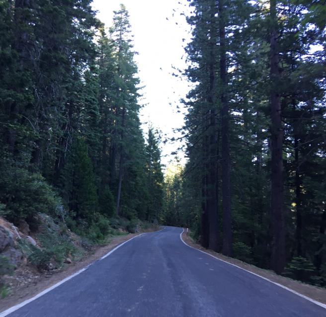
From Mineral CA 172 eastbound begins as a one-lane highway.

CA 172 eastbound travels through a small valley before ascending onto a mountain grade. CA 172 more or less straddles the divide between where the Sierra Nevada Mountains transitions into the volcanic Cascade Mountains.

I didn't encounter another vehicle on CA 172, most of the one-lane portion of the highway closes during winter months. The climb to Mineral Summit is fairly straight-forward although a little rougher than the typical one-lane state highways I've encountered in the past. Mineral Summit is located at Post Mile TEH 2.274.


The descent to Mill Creek on CA 172 east from Mineral Summit is fairly tame given there isn't much of an elevation drop. CA 172 eastbound enters Mill Creek at approximately Postmile TEH 5.78. Mill Creek is located at 4,737 feet above sea level. Mill Creek takes it's name from the nearby creek which CA 172 follows east of Mineral Summit.


East of Mill Creek CA 172 widens out to the width of a two lane highway but lacks a center stripe. Winter plowing of CA 172 occurs from Mill Creek east to to CA 36/CA 89. CA 172 eastbound terminates CA 36/CA 89 at Postmile TEH 8.91.


The CA 172 junction from CA 36 west/CA 89 north.

Comments