Within the Truckee River Canyon in the Sierra Nevada range numerous abandoned portions of US Route 40 can be found alongside modern Interstate 80.
This segment of highway was opened during 1926 as a bypass of the Dog Valley Grade which carried the early North Lincoln Highway and Victory Highway. The corridor of the Truckee River Canyon State Highway would be assigned as US Route 40 when the US Route System was commissioned during November 1926. During 1958 the segment of Interstate 80 between Boca, California and the Nevada state line was complete. When Interstate 80 opened east of Boca numerous obsolete portions of US Route 40 were abandoned. Some of these abandoned segments have been incorporated into the Tahoe-Pyramid Trail.
Part 1; the history of US Route 40 in the Truckee River Canyon
The Truckee River Canyon for centuries has been an established corridor of travel known to native tribes crossing the Sierra Nevada range. The first documented wagon crossing of the Sierra Nevada was made in 1844 by the Townsend-Murphys Party. From the vicinity of modern-day Verdi, Nevada the Townsend-Murphy Party traveled westward via the Truckee River Canyon towards what is known now as Donner Lake. This routing proved hazardous which led to an alternate routing being scouted through Dog Valley by Caleb Greenwood in 1845. The Dog Valley Grade would be favored by most immigrant parties including the ill-fated Donner Party during the Fall of 1846.
Much of the early history of the Dog Valley Grade is discussed in the September 1950 Centennial Edition of California Highways & Public Works. The volume notes the difficulties faced by the Townsend-Murphy Party in the Truckee River Canyon and the utility of the Dog Valley Grade.
The below illustration found in the September 1950 California Highways & Public Works depicts the Dog Valley Grade (1) from the Nevada state line west to Truckee. The Dog Valley Grade is shown intersecting with the Henness Pass Road (2) in Dog Valley and then modern US Route 40 in Truckee.


The utility of the Dog Valley Grade was further enhanced by the development of the Henness Pass Road. During 1849-1850 Patrick Henness developed a Native American trail into what came to be known as the "Henness Pass Road." The Henness Pass Road began at Truckee River in Verdi and climbed west through the Sierra Nevada Mountains via Dog Valley towards Camptonville. The Henness Pass Road was surveyed as a possible all-year wagon road over the Sierra Nevada Mountains by D.B. Scott in 1855 at the behest of the California Legislature (
from the September 1950 California Highways & Public Works). Usage of the Henness Pass Road would peak during 1860-1868 when it was developed as a franchise toll road alternative to the Lake Tahoe Wagon Road.
The Dog Valley Grade can be seen as a component of the Henness Pass Road on the
1857 Britton & Rey's Map of California. The same map depicts the highway towards Donner Pass favoring the earlier routing through the Truckee River Canyon.

The Dog Valley Grade would be connected to the Dutch Flat & Donner Lake Road (DF&DLR) during the construction of the Central Pacific Railroad. During 1861 the State of California granted the Central Pacific Railroad a 10-year franchise on toll rights to the Dutch Flat & Donner Lake Road (DF&DLR) which completed by 1864. The DF&DLR was used to finance the Central Pacific Railroad's construction of the First Transcontinental Railroad from 1864 to 1868. The DF&DLR was likely not tolled after the Central Pacific Railroad was completed over the Sierra Nevada Mountains via Donner Pass and the Truckee River Canyon during Spring of 1868. The DF&DLR became a public highway in 1871 and was only loosely maintained given rail service had become the easiest form of transportation over Donner Pass.
During 1912 Indiana Businessman Carl G. Fisher conceptualized the Lincoln Highway as a major transcontinental Auto Trail. The Lincoln Highway was formally dedicated on October 31, 1913, and was aligned west of Fallon via split branches over the Sierra Nevada Mountains. The original northern branch of the Lincoln Highway (displayed in blue) is shown on the Lincoln Highway Association's Official Map from Verdi, Nevada via the Dog Valley Grade to Truckee, California.
The 1919 Third State Highway Bond Act added an addition to
Legislative Route Number 38 (LRN 38) which defined a new segment of State Highway intended to replace the Dog Valley Grade:
"A certain highway Nevada and Sierra counties, running as follows: From a point in the town of Truckee where the present state highway branches at the subway under the Southern Pacific tracks going toward Lake Tahoe, continuing through the town of Truckee, crossing Prosser Creek and over what is known as the "Dog Valley Grade" as far as the state line about 1 mi NW of Verdi, Nevada..."


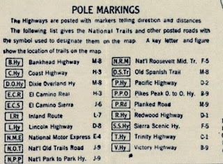
The Victory Highway was formally organized during 1921 as a coast-to-coast highway aligned from New York to San Francisco. The Victory Highway Association lived on after the creation of the US Route System and became the US Route 40 Association in 1938.


The initial draft of the US Route System was approved by the Secretary of Agriculture during November of 1925. The US Route System within California was approved by California Highway Commission with no changes recommended by January 1926. The alignment of US Route 40 east of Sacramento was planned to follow the existing Northern Branch of the Lincoln Highway and Victory Highway over LRN 3, LRN 17, LRN 37 and LRN 38 to the Nevada state line at Verdi.
Thusly US Route 40 appears on the 1925 Rand McNally Map of California east of Sacramento to Verdi. Conceptual US Route 40 is shown following the Dog Valley Grade east of Truckee.
The May 1926 California Highways & Public Works noted LRN 38 in the Truckee River Canyon between Truckee and the Nevada state line as having been fully graded. The new segment of LRN 38 is stated to have a planned opening on June 10th, 1926, as a bypass to the Dog Valley Grade.
The completion of LRN 38 east of Truckee to Verdi by way of the Truckee River Canyon was featured in the
June 1926 California Highways & Public Works. The 19.1 mile long "Truckee River Highway" was dedicated on June 10, 1926, by California Governor Friend Richardson.
The US Route System was formally approved by the American Association of State Highway Officials (AASHO) on November 11, 1926. The approval of the US Route System formally brought US Route 40 into existence east of Sacramento to the Nevada State Line. Notably US Route 40 east of Sacramento to the Nevada State Line was referred to as the Victory Highway in numerous official documents into the 1930s. US Route 40 from the outset of the US Route System was aligned through the Truckee River Canyon east of Truckee to Verdi.
On June 29, 1956, the Federal Highway Aid Act of 1956 was signed into law on the Federal Level. The Federal Highway Aid Act of 1956 was the genesis point of the Interstate Highway System which would in the coming decade sew the demise of US Route 40 in California.
The
November/December 1957 California Highways & Public Works features numerous updates to US 40 in the Sierra Nevada Mountains. US Route 40/LRN 17 in the Newcastle-Auburn corridor is stated to be 75% complete. US Route 40/LRN 37 in the Heather Glen-Colfax corridor is stated to be in the process of grading. The US Route 40/LRN 37 freeway in the Colfax-Magra corridor as well as Truckee-Nevada State Line is stated to be in the process of construction.


The
July/August 1958 California Highways & Public Works notes the US Route 40/LRN 17 freeway in the Newcastle-Auburn corridor was slated to open during the summer of 1958. The Heather Glen-Colfax freeway corridor of US Route 40/LRN 37 is stated to have an anticipated opening during summer 1958. The Colfax-Magra freeway corridor of US Route 40/LRN 37 is stated to have an anticipated opening during fall 1958. The Boca-Stateline freeway corridor of US Route 40/LRN 38 is stated to have an anticipated opening during summer 1958.
Following the completion of the Boca-Nevada state line freeway portions numerous segments of the 1926-era alignment of US Route 40 were abandoned. One such segment was located in Sierra County which remains accessible from the eastbound lanes of Interstate 80.
Part 2; a hike on abandoned US Route 40 in the Truckee River Canyon
East of Interstate 80 Exit 201 between Floriston, California and Verdi, Nevada a shoulder-side trailhead parking area can be found along the Truckee River.
From the parking area abandoned US Route 40 can be found behind a gate.
Abandoned US Route 40 is part of the Tahoe-Pyramid Trail. A connecting path to Fleish Dam & Bridge can found along with a historic information station.
Portions of white center stripe can be found along abandoned US Route 40. Striping of this kind was commonly used by the Division of Highways during the late 1950s.




Comments