California State Route 206 was a short eight-mile State Highway which existed in the San Bernadino area. Prior to the 1964 State Highway Renumbering what would become California State Route 206 was part of the original US Route 66 Business Loop via Kendall Drive and E Street towards downtown San Bernardino. As defined in 1964, California State Route 206 began at California State Route 30 in San Bernadino and terminated at Interstate 15 in Verdemont. California State Route 206 was ultimately deleted from the State Highway System in 1991. The original US Route 66 Business Loop can be seen co-signed with California State Route 18 at the I Street Overhead along 5th Street in San Bernardino circa 1951.
The history of California State Route 206
What was to become California State Route 206 (CA 206) was first brought into the State Highway System as part of 1933 Legislative Chapter 767 as Legislative Route Number 191 (LRN 191). The initial definition of LRN 191 was as follows:
"LRN 31 (US Route 395) near Verdemont to Highland Avenue, San Bernardino via Little Mountain."
LRN 191 is announced in the April 1933 California Highways & Public Works as a new 8-mile State Highway.
LRN 191 thusly first appears on the 1934 Division of Highways Map. LRN 191 was not assigned one of the initial Sign State Routes which were announced in the August 1934 California Highways & Public Works.
LRN 191 appears in detail on the
1935 Division of Highways Map of San Bernardino County. LRN 191 can be seen following Kendall Drive and E Street.

The
October 1937 California Highways & Public Works announced contracts to construct a new bridge over Cable Creek on LRN 191.
The
November/December 1955 California Highways & Public Works notes in an article about improvements to Cajon Pass and references LRN 191 being signed as US Route 66 Alternate (in reality US Route 66 Business). The US Route 66 Business Loop followed LRN 191 on Kendall Drive and E Street to Highland Avenue. From Highland Avenue the US Route 66 Business Loop followed CA 18 via E Street and 5th Street back to mainline US Route 66 through downtown San Bernardino. The original US Route 66 Business Loop in San Bernardino is unique in that it was chosen to follow an alignment which never part of mainline US Route 66.

A clue to the origin of the original US Route 66 Business Loop in San Bernardino can be found in the
September/October 1951 California Highways & Public Works. Said volume features the I Street Overhead which opened on September 10, 1951, along 5th Street. The I Street Overhead is cited to carry CA 18 and US Route 66 Business via LRN 9 over what had been previous an at-grade crossing of the Atchison, Topeka & Santa Fe Railway (ATSF) mainline through San Bernardino. Prior to the opening of the I Street Overhead both CA 18 and US Route 66 Alternate were aligned on 3rd Street.
Notably a US Route 66 Alternate is displayed on Kendall Drive and E Street on LRN 191 on the 1941 USGS Map of the San Bernardino area. The presence of US Route 66 Alternate on the 1941 USGS Map suggests it was present before 1940.
The 1942 USGS Map of San Bernardino displays CA 18 and US Route 66 Alternate on 3rd Street between E Street and Mount Vernon Avenue. US Route 66 Alternate would have connected with mainline US Route 66 at 4th Street via Mount Vernon Avenue.

The AASHTO Database does not have an application for a US Route 66 Alternate or Business Loop in San Bernardino between 1926-1940. An exchange of 1930 letters between the California State Highway Engineer and AASHO Executive Secretary alludes to a US Route 66 Alternate existing somewhere east of Pasadena. Specifically, the California State Highway Engineer asks for clarification on the approval process for US Route Alternates on January 29, 1930. The California State Highway Engineer notes a US Route 66 Alternate east of Pasadena as being signed by uncited local authority. On February 3, 1930, the Executive Secretary notes that a submission to the AASHO Executive Committee should be made to approve an Alternate US Route 66. A reply by the State Highway Engineer on February 10, 1930, notes the unnamed local authority had taken it upon themselves to sign US Route 66 on a county road instead of the local State maintained highway.


While the above does not explicitly state as such, it is this likely is the origin of US Route 66 Alternate/Business in San Bernardino was a local signing project which was never approved by the AASHO Executive Commitee. It seems equally likely LRN 191 was adopted to bring US Route 66 Alternate under State maintenance when the opportunity presented itself during 1933. (Author's Note: generally, I do not like to include such conjecture in blogs. However, it seems necessary given the evidence is directing me to read between the lines.)

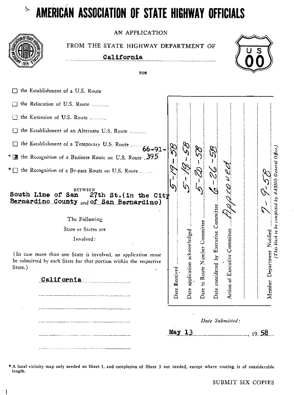
The Division of Highways submitted a request on May 13, 1958, to create a new US Route 66-91-395 Business Loop in San Bernardino due to the construction of Interstate 15. The new US Route 66 Business Loop is shown to follow Mount Vernon Avenue and 5th Street in San Bernardino via the original surface routing of the highway. The request by the Division of Highways also sought to eliminate the existing US Route 66 Business Loop on LRN 191, Kendall Drive, E Street and 5th Street. The AASHO approved the Division of Highways request on June 26, 1958, which eliminated the US Route 66 Business Loop on LRN 191.
As part of the 1964 State Highway Renumbering all Legislative Route Numbers were dropped in favor of field signage. Legislative Route Numbers without Sign State Routes were subsequently assigned one. LRN 191 was reassigned as CA 206 and appears for the first time on the
1964 Division of Highways Map.
1976 Legislative Chapter 1354 changed the northern terminus of CA 206 to "Route 194" to reflect the shift of Interstate 15 and replacement by Interstate 15E. The new terminus of CA 206 at Interstate 15E/hidden CA 194 appears on the
1977 Caltrans Map.
1982 Legislative Chapter 681 changed the northern terminus of CA 206 to "Route 215" to reflect the reassignment of Interstate 15E to Interstate 215. CA 206 was ultimately deleted from the State Highway System by way of 1991 Assembly Bill 1886, Chapter 928.




Comments