McKinley Grove Road to the Wishon Reservoir, Courtright Way to the Courtright Reservoir, and a dog named Dinkey
This past week the forecast high in Fresno was 109F. Given that I wasn't in the mood to sit around a sweltering City on a day off I decided to take a day trip to the Sierra Nevada Mountains and Sierra National Forest. My journey into Sierra National Forest would take me on McKinley Grove Road/Forest Road 11s040 and Courtright Way/Forest Road 10s016 to locales such as; the 1938 Dinkey Creek Bridge, the McKinley Grove of Sequoias, the Wishon Reservoir, and Courtright Reservoir.

Part 1; McKinley Grove Road, a dog named Dinkey, the 1938 Dinkey Creek Bridge, the McKinley Grove, and Wishon Reservoir
My approach to McKinley Grove was eastbound from Dinkey Creek Road.


From Dinkey Creek Road there is a mileage sign showing that the Wishon Reservoir is 16 miles to the east whereas the Courtright Reservoir is shown to be 21 miles away. McKinley Grove Road is maintained as Forest Road 11s040 and ends approximately 18 miles east of Dinkey Creek Road beyond the Wishon Reservoir at Little Rancheria Creek.

McKinley Grove Road eastbound begins with a quick crossing of Dinkey Creek at a starting elevation of approximately 5,987 feet above sea level. On the east bank of Dinkey Creek the Dinkey Creek Day Use Area can be found which is a popular fishing locale.


McKinley Grove Road eastbound intersects Dinkey Fisherman Road/Forest Road 10s453 just beyond the Dinkey Creek Day use area. Dinkey Fisherman Road is the original alignment of McKinley Grove Road and sometimes appears as "Old McKinley Grove Road" on some maps.

A quick detour onto Dinkey Fisherman Road reveals the Dinkey Fisherman Picnic Area and the 1938 Dinkey Creek Bridge.


The 1938 Dinkey Creek Bridge as noted above is the only Bowstring Arch Truss structure in California. The 1938 Dinkey Creek Bridge was largely built to encourage tourism to the McKinley Redwood Sequoia Grove and interior of Sierra National Forest. The 1938 Dinkey Creek Bridge was replaced by a new structure in 1956 to downstream to facilitate construction of the Wishon and Courtright Reservoirs. The 1938 Dinkey Creek Bridge was closed automotive traffic in 1965 and was restored in 1988. The 1938 Dinkey Creek Bridge was placed on the National Register of Historic Places in 1996. The namesake Dinkey Creek is named after a dog during the California Gold Rush in 1863 which attempted to fight a grizzly bear and lost. The 1938 Dinkey Creek Bridge is 92 feet long, the two photos below are looking north upstream on Dinkey Creek.


I crossed the 1938 Dinkey Creek Bridge westward into the community of Dinkey Creek.


Dinkey Creek is a former sawmill community which essentially exists now to cater recreation opportunities at the namesake creek. There was a large logging operation at Dinkey Creek operated by the Pine Logging Company from 1937 through 1979. The community of Dinkey Creek can be seen on the 1935 Division of Highways Map of Fresno County at the eastern terminus of Dinkey Creek Road.

The western approach of the 1938 Dinkey Creek Bridge has a historic plaque on one of the barrier rocks.


Returning to McKinley Grove Road the route eastbound begins to ascend. A small bridge can be found at Bear Creek which had a very active waterfall from the winter snow melt.


McKinley Grove Road east of Bear Creek ascends to the McKinley Grove of Redwood Sequoias. The McKinley Grove is 5.8 miles east of Dinkey Creek Road and can be found at an elevation of 6,316 feet above sea level.


The McKinley Grove was discovered by settlers during 1869 and was originally known as the General Washington Grove. The McKinley Grove is a somewhat small Sequoia Grove containing 216 trees and has never been logged. The largest Sequoia in McKinley Grove is about 230 feet high and is approximately 2,000 years old. The McKinley Grove was added to Sierra National Forest during 1893 and for a time was known as Dusy Grove in honor of explorer Frank Dusy. The McKinley Grove took it's modern name in the early 1900s. The name "McKinley Grove" is meant to honor the 25th President William McKinley. The present McKinley Grove Trail was constructed in 1990.


East of McKinley Grove the route of McKinley Grove Road passes by the Gigantea Campground.


East of the Gigantea Campground the route of McKinley Grove Road opens onto a clearing from where San Joaquin Valley can be seen below. Given the poor weather in San Joaquin Valley the view obstructed the Diablo Range via a haze of dust.

McKinley Grove Road eastbound continues to ascend and passes through Brush Meadow at 6,720 feet above sea level.


Brush Creek essentially serves the half-way point of McKinley Grove Road as looking westbound shows it is 9 miles from Dinkey Creek Road.

McKinley Grove Road continues eastward as passes by the Buck Meadow Campground.


East of Buck Meadow the route of McKinley Grove Road intersects the infamous Blackrock Road/Forest Road 11s012.


From Blackrock Road the route of McKinley Grove Road begins to descend and intersects Courtright Way/Forest Road 10s016.


McKinley Grove Road eastbound passes through the Pacific Gas & Electricity ("PG&E") Wishon Camp and descends to Wishon Dam.


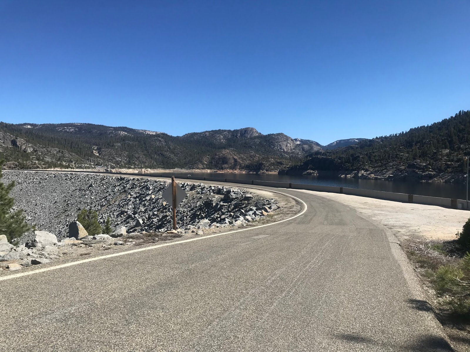
Wishon Dam forms the namesake Wishon Reservoir by way of impounding the North Fork Kings River. Wishon Dam was completed during 1958 by PG&E and serves the bridging structure for McKinley Grove Road. Wishon Dam is an earthen structure which lies at an elevation of 6,554.9 feet above sea level, is 3,328 feet in length and 265 feet high from the foundation. McKinley Grove Road crosses atop Wishon Dam on a one-lane alignment.


McKinley Grove Road crosses over the spillway of Wishon Dam on a one-lane bridge.


I made a brief stop at the Coolidge Meadow Fishing Area before turning westward over Wishon Dam via McKinley Grove Road.


Part 2; Courtright Way to the Courtright Reservoir
Upon passing through Wishon Village I made a right hand turn from McKinley Grove Road westbound onto Courtright Way northbound.

From McKinley Grove Road the route north to the Courtright Reservoir on Courtright Way is approximately 7.4 miles. Courtright Way is maintained as Forest Road 10s016 and is largely a one-lane paved roadway.

Courtright Way northbound begins with a fast climb to an approximate peak elevation of 8,600 feet. Upon peaking in elevation Courtright Way emerges onto a switchback which overlooks the Wishon Reservoir.


Courtright Way passes by the Leconte Divide Overlook. The Leconte Divide is a topographical line of peaks in the Sierra Nevada Mountains which separate the Kings River Watershed from the San Joaquin River Watershed. The 13,568 foot high Mount Goddard can be observed from the Leconte Divide Overlook.


Courtright Way continues northward snaking through the terrain and emerges onto a three-way road fork at the Courtright Reservoir. Left at the fork continues on Courtright Way towards a PG&E encampment, the center road is Marmot Rock Campground Road/Forest Road 10s096 which leads to a boat launch, the right road is Courtright Dam Road/Forest Road 09s038 which heads to Courtright Dam.


I turned right onto Courtright Dam Road which has signage directing traffic to the Dusy Ershim OHV Trail/Forest Road 07s032 and Maxson Trailhead.


Courtright Dam Road is a single lane and begins by crossing a concrete slab over the Courtright Dam spillway.


Courtright Way crosses Courtright Dam via a one-way alignment. Courtright Dam impounds Helms Creek and was completed alongside Wishon Dam by PG&E during 1958. Courtright Dam is a earthen structure which lies at 8,170 feet above sea level and has 315 feet height from it’s base. Atop Courtright Dam looking south reveals a wide vista above Helms Creek. The formation known as the Power Dome can be seen on the east bank of Helms Creek.


Upon crossing Courtright Dam I climbed down the east bank of Helms Creek to get a better view of the structure.


Suffice to say few roads have quite the intimidating view and drop off that Courtright Dam Road does.

Before heading towards Fresno I did stop at the boat launch on Marmot Campground Road for brief lunch overlooking the Courtright Reservoir.


Part 1; McKinley Grove Road, a dog named Dinkey, the 1938 Dinkey Creek Bridge, the McKinley Grove, and Wishon Reservoir
My approach to McKinley Grove was eastbound from Dinkey Creek Road.


From Dinkey Creek Road there is a mileage sign showing that the Wishon Reservoir is 16 miles to the east whereas the Courtright Reservoir is shown to be 21 miles away. McKinley Grove Road is maintained as Forest Road 11s040 and ends approximately 18 miles east of Dinkey Creek Road beyond the Wishon Reservoir at Little Rancheria Creek.

McKinley Grove Road eastbound begins with a quick crossing of Dinkey Creek at a starting elevation of approximately 5,987 feet above sea level. On the east bank of Dinkey Creek the Dinkey Creek Day Use Area can be found which is a popular fishing locale.


McKinley Grove Road eastbound intersects Dinkey Fisherman Road/Forest Road 10s453 just beyond the Dinkey Creek Day use area. Dinkey Fisherman Road is the original alignment of McKinley Grove Road and sometimes appears as "Old McKinley Grove Road" on some maps.

A quick detour onto Dinkey Fisherman Road reveals the Dinkey Fisherman Picnic Area and the 1938 Dinkey Creek Bridge.


The 1938 Dinkey Creek Bridge as noted above is the only Bowstring Arch Truss structure in California. The 1938 Dinkey Creek Bridge was largely built to encourage tourism to the McKinley Redwood Sequoia Grove and interior of Sierra National Forest. The 1938 Dinkey Creek Bridge was replaced by a new structure in 1956 to downstream to facilitate construction of the Wishon and Courtright Reservoirs. The 1938 Dinkey Creek Bridge was closed automotive traffic in 1965 and was restored in 1988. The 1938 Dinkey Creek Bridge was placed on the National Register of Historic Places in 1996. The namesake Dinkey Creek is named after a dog during the California Gold Rush in 1863 which attempted to fight a grizzly bear and lost. The 1938 Dinkey Creek Bridge is 92 feet long, the two photos below are looking north upstream on Dinkey Creek.


I crossed the 1938 Dinkey Creek Bridge westward into the community of Dinkey Creek.


Dinkey Creek is a former sawmill community which essentially exists now to cater recreation opportunities at the namesake creek. There was a large logging operation at Dinkey Creek operated by the Pine Logging Company from 1937 through 1979. The community of Dinkey Creek can be seen on the 1935 Division of Highways Map of Fresno County at the eastern terminus of Dinkey Creek Road.

The western approach of the 1938 Dinkey Creek Bridge has a historic plaque on one of the barrier rocks.


Returning to McKinley Grove Road the route eastbound begins to ascend. A small bridge can be found at Bear Creek which had a very active waterfall from the winter snow melt.


McKinley Grove Road east of Bear Creek ascends to the McKinley Grove of Redwood Sequoias. The McKinley Grove is 5.8 miles east of Dinkey Creek Road and can be found at an elevation of 6,316 feet above sea level.


The McKinley Grove was discovered by settlers during 1869 and was originally known as the General Washington Grove. The McKinley Grove is a somewhat small Sequoia Grove containing 216 trees and has never been logged. The largest Sequoia in McKinley Grove is about 230 feet high and is approximately 2,000 years old. The McKinley Grove was added to Sierra National Forest during 1893 and for a time was known as Dusy Grove in honor of explorer Frank Dusy. The McKinley Grove took it's modern name in the early 1900s. The name "McKinley Grove" is meant to honor the 25th President William McKinley. The present McKinley Grove Trail was constructed in 1990.


East of McKinley Grove the route of McKinley Grove Road passes by the Gigantea Campground.


East of the Gigantea Campground the route of McKinley Grove Road opens onto a clearing from where San Joaquin Valley can be seen below. Given the poor weather in San Joaquin Valley the view obstructed the Diablo Range via a haze of dust.

McKinley Grove Road eastbound continues to ascend and passes through Brush Meadow at 6,720 feet above sea level.


Brush Creek essentially serves the half-way point of McKinley Grove Road as looking westbound shows it is 9 miles from Dinkey Creek Road.

McKinley Grove Road continues eastward as passes by the Buck Meadow Campground.


East of Buck Meadow the route of McKinley Grove Road intersects the infamous Blackrock Road/Forest Road 11s012.


From Blackrock Road the route of McKinley Grove Road begins to descend and intersects Courtright Way/Forest Road 10s016.


McKinley Grove Road eastbound passes through the Pacific Gas & Electricity ("PG&E") Wishon Camp and descends to Wishon Dam.


Wishon Dam forms the namesake Wishon Reservoir by way of impounding the North Fork Kings River. Wishon Dam was completed during 1958 by PG&E and serves the bridging structure for McKinley Grove Road. Wishon Dam is an earthen structure which lies at an elevation of 6,554.9 feet above sea level, is 3,328 feet in length and 265 feet high from the foundation. McKinley Grove Road crosses atop Wishon Dam on a one-lane alignment.


McKinley Grove Road crosses over the spillway of Wishon Dam on a one-lane bridge.


I made a brief stop at the Coolidge Meadow Fishing Area before turning westward over Wishon Dam via McKinley Grove Road.




Part 2; Courtright Way to the Courtright Reservoir
Upon passing through Wishon Village I made a right hand turn from McKinley Grove Road westbound onto Courtright Way northbound.

From McKinley Grove Road the route north to the Courtright Reservoir on Courtright Way is approximately 7.4 miles. Courtright Way is maintained as Forest Road 10s016 and is largely a one-lane paved roadway.

Courtright Way northbound begins with a fast climb to an approximate peak elevation of 8,600 feet. Upon peaking in elevation Courtright Way emerges onto a switchback which overlooks the Wishon Reservoir.


Courtright Way passes by the Leconte Divide Overlook. The Leconte Divide is a topographical line of peaks in the Sierra Nevada Mountains which separate the Kings River Watershed from the San Joaquin River Watershed. The 13,568 foot high Mount Goddard can be observed from the Leconte Divide Overlook.


Courtright Way continues northward snaking through the terrain and emerges onto a three-way road fork at the Courtright Reservoir. Left at the fork continues on Courtright Way towards a PG&E encampment, the center road is Marmot Rock Campground Road/Forest Road 10s096 which leads to a boat launch, the right road is Courtright Dam Road/Forest Road 09s038 which heads to Courtright Dam.


I turned right onto Courtright Dam Road which has signage directing traffic to the Dusy Ershim OHV Trail/Forest Road 07s032 and Maxson Trailhead.


Courtright Dam Road is a single lane and begins by crossing a concrete slab over the Courtright Dam spillway.


Courtright Way crosses Courtright Dam via a one-way alignment. Courtright Dam impounds Helms Creek and was completed alongside Wishon Dam by PG&E during 1958. Courtright Dam is a earthen structure which lies at 8,170 feet above sea level and has 315 feet height from it’s base. Atop Courtright Dam looking south reveals a wide vista above Helms Creek. The formation known as the Power Dome can be seen on the east bank of Helms Creek.


Upon crossing Courtright Dam I climbed down the east bank of Helms Creek to get a better view of the structure.


Suffice to say few roads have quite the intimidating view and drop off that Courtright Dam Road does.

Before heading towards Fresno I did stop at the boat launch on Marmot Campground Road for brief lunch overlooking the Courtright Reservoir.


Comments