This February I stopped at the site of the abandoned railroad siding known as Locans in eastern Fresno County.

Locans was a railroad sidings of the Southern Pacific Railroad spur line known as the Stockton & Tulare Railroad. Locans was located on what is now Temperance Avenue just south of Bulter Avenue. The Stockton & Tulare Railroad was completed in 1887 but it doesn't appear that Locans was one of the original sidings. Locans doesn't appear on the 1889 George F. Cram Railroad map of California but nearby Butler does.

The first reference to Locans I can find is on the 1891 Thompson Atlas of Fresno County. A large parcel of land next to the Stockton & Tulare Railroad can be seen east of of Butler owned by F. Locan. Locan's land holdings surround a small siding known as Minneola which was about a half mile east of where the site of Locans would eventually be plotted.

Locan's property appears again on the Stockton & Tulare Railroad between Butler and Minneola as "Locan Colony" on the 1914 Weber & Company Map of Fresno County.

The first true sighting of Locans I can find is on a 1923 USGS Topographical Map hosted on historicaerials.com where it is referred to in error as "Logans." Of note; Minneola is not shown on the 1923 USGS Map which suggests that it was razed and consolidated into Locans. Locans included two switches from the Stockton & Tulare Railroad with at least 19 buildings at the siding facility. The Locan School (shown as Logan School) can be seen a half mile to the north on Ventura Avenue. Ventura Avenue would later become Kings Canyon Road which in turn became part of Legislative Route 41 during the 1919 Third State Highway Bond Act. In 1934 Kings Canyon Road was Signed as part of California State Route 180 which put the Locans School on a major highway.

Locans appears on the Stockton & Tulare Railroad between Butler and Ivesta on the 1935 California Division of Highways Map of Fresno County.

Locans has never disappeared on USGS maps but the siding seems to have been replaced by a modernized distribution facility sometime between 1954 and 1965. The 1965 USGS Map seems to suggest that the Locans School had closed at some point after 1954. The 1954 USGS Topographical Map and 1965 USGS Topographical Map can be seen hosted on historicaerials.com.

Interestingly the distribution center first seen on the 1965 USGS Map replacing Locans is still present. Said distribution center is presently occupied by Lidestri Foods who seemingly used the dual switch to Locans until fairly recently. From Temperance Avenue and Union Pacific mainline overpass the Locans Switch approaching Lidestri Foods can be seen looking northbound.
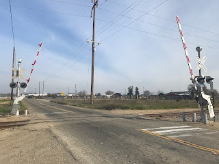
This view is from the Union Pacific mainline looking at the terminus of the western Locans switch. The City of Fresno hasn't annexed the former siding of Locans but new neighborhoods within in the City Limit can be seen.

The photos below look eastbound from the Union Pacific mainline at the Locans Switch.


This view is of Temperance Avenue southbound looking at the convergence of the Locans Switch.

The spur line to Locans can be seen following Temperance Avenue northbound towards the Lidestri Foods facility. Some of the spur line to Locans is partially buried which seems to have been placed to allow heavy trucks to park.


Heading north to the intersection of Temperance Avenue and former CA 180 on Kings Canyon Road an old service station can be found.

The Locan School is still present on former CA 180 on Kings Canyon Road. CA 180 east of Clovis Avenue to Locan Avenue was moved to a new freeway grade in 2007 which led to Kings Canyon Road at the Locan School being relinquished.


The Locan School is presently occupied by the South Gate Church. Amusingly the South Gate Church website states that it is located at the Locan School but doesn't say anything insight about the building itself.


The Locan School still displays the name it carried during it's days servicing the rail siding of Locans. The Locan School much like the Locans Switch is located just east of the City Limit of Fresno.


Locans was a railroad sidings of the Southern Pacific Railroad spur line known as the Stockton & Tulare Railroad. Locans was located on what is now Temperance Avenue just south of Bulter Avenue. The Stockton & Tulare Railroad was completed in 1887 but it doesn't appear that Locans was one of the original sidings. Locans doesn't appear on the 1889 George F. Cram Railroad map of California but nearby Butler does.

The first reference to Locans I can find is on the 1891 Thompson Atlas of Fresno County. A large parcel of land next to the Stockton & Tulare Railroad can be seen east of of Butler owned by F. Locan. Locan's land holdings surround a small siding known as Minneola which was about a half mile east of where the site of Locans would eventually be plotted.

Locan's property appears again on the Stockton & Tulare Railroad between Butler and Minneola as "Locan Colony" on the 1914 Weber & Company Map of Fresno County.

The first true sighting of Locans I can find is on a 1923 USGS Topographical Map hosted on historicaerials.com where it is referred to in error as "Logans." Of note; Minneola is not shown on the 1923 USGS Map which suggests that it was razed and consolidated into Locans. Locans included two switches from the Stockton & Tulare Railroad with at least 19 buildings at the siding facility. The Locan School (shown as Logan School) can be seen a half mile to the north on Ventura Avenue. Ventura Avenue would later become Kings Canyon Road which in turn became part of Legislative Route 41 during the 1919 Third State Highway Bond Act. In 1934 Kings Canyon Road was Signed as part of California State Route 180 which put the Locans School on a major highway.

Locans appears on the Stockton & Tulare Railroad between Butler and Ivesta on the 1935 California Division of Highways Map of Fresno County.

Locans has never disappeared on USGS maps but the siding seems to have been replaced by a modernized distribution facility sometime between 1954 and 1965. The 1965 USGS Map seems to suggest that the Locans School had closed at some point after 1954. The 1954 USGS Topographical Map and 1965 USGS Topographical Map can be seen hosted on historicaerials.com.

Interestingly the distribution center first seen on the 1965 USGS Map replacing Locans is still present. Said distribution center is presently occupied by Lidestri Foods who seemingly used the dual switch to Locans until fairly recently. From Temperance Avenue and Union Pacific mainline overpass the Locans Switch approaching Lidestri Foods can be seen looking northbound.

This view is from the Union Pacific mainline looking at the terminus of the western Locans switch. The City of Fresno hasn't annexed the former siding of Locans but new neighborhoods within in the City Limit can be seen.

The photos below look eastbound from the Union Pacific mainline at the Locans Switch.


This view is of Temperance Avenue southbound looking at the convergence of the Locans Switch.

The spur line to Locans can be seen following Temperance Avenue northbound towards the Lidestri Foods facility. Some of the spur line to Locans is partially buried which seems to have been placed to allow heavy trucks to park.


Heading north to the intersection of Temperance Avenue and former CA 180 on Kings Canyon Road an old service station can be found.

The Locan School is still present on former CA 180 on Kings Canyon Road. CA 180 east of Clovis Avenue to Locan Avenue was moved to a new freeway grade in 2007 which led to Kings Canyon Road at the Locan School being relinquished.


The Locan School is presently occupied by the South Gate Church. Amusingly the South Gate Church website states that it is located at the Locan School but doesn't say anything insight about the building itself.


The Locan School still displays the name it carried during it's days servicing the rail siding of Locans. The Locan School much like the Locans Switch is located just east of the City Limit of Fresno.

Comments