On a recent trip to the Mid-West I drove a section of freeway I haven't been on since the late 1990s; the Kennedy Expressway from Chicago O'Hare International Airport east to Interstate 290 in downtown Chicago.

The Kennedy Expressway is a designation of 17.8 miles of freeway consisting parts of Interstate 190, 90 and 94 between Chicago O'Hare and I-290 in downtown Chicago. Expressway designations in the Chicago Area refer to free access freeway grades as opposed to limited access toll roads. Much of the Interstate network around Chicago consists of toll road segments. In the case of the Kennedy Expressway the free designation has made it the main east/west arterial freeway in the Chicago area which carries a massive peak daily traffic count of approximately 327,000 vehicles.
In short; construction of the Kennedy Expressway began in 1955 with portions opening 1958. The entirety of the Kennedy Expressway opened in November 1960 with reversible lanes opening up in early 1961. The original name of the Kennedy Expressway was known as the "Northwest Expressway" and was designated as Illinois State Route 194 from Chicago O'Hare east to I-94. I-90 at the time was routed along the Eisenhower Expressway which is now I-290. In November of 1963 the Northwest Expressway was officially re-designated as the Kennedy Expressway following the assassination of President John F. Kennedy. In 1978 I-90 was routed onto the Kennedy Expressway via the Jane Addams Memorial Tollway east over what was IL 194 to a multiplex of I-94. I-190 was also created in 1978 from the remaining segment of IL 194 on the Kennedy Expressway from Chicago O'Hare to I-90.
A much more detailed historic overview of the Kennedy Expressway can be found on Chicagoroads.com.
chicagoroads.com on the Kennedy Expressway
My drive on the Kennedy Expressway began from the Chicago O'Hare rental car parking lot on US 12/US 45 on Mannheim Road. US 12/US 45 connects with the Kennedy Expressway via I-190. Both I-190 and the Kennedy Expressway have a western terminus at the main domestic terminal building of Chicago O'Hare.


The first major junction east of US 12/US 45 on the Kennedy Expressway/I-190 is in Rosemont at Exit 1C/1D for I-294 Tollway. I-90 west traffic is directed to take Exit 1C for I-294 northbound.


The last Rosemont Exit on the Kennedy Expressway/I-190 eastbound is at River Road. East of River Road I-190 terminates and the Kennedy Expressway merges onto I-90 in the City Limits of Chicago. The first major junction on the I-90 portion of the Kennedy Expressway is at Exit 79A/B for IL 171 on Cumberland Avenue.


It quickly becomes apparent how heavy traffic is on the I-90 portion of the Kennedy Expressway by looking at the traffic time VMS signage. The merge portion for I-94 on the Kennedy Expressway is usually quickly reached but beyond that traffic tends to grind to a crawl. The Kennedy Expressway likely is the source of the road meme that "Chicago is an hour from Chicago."

The next major junction on the I-90 portion of the eastbound Kennedy Expressway is at Exit 81A for IL 43 on Harlem Avenue.


The I-90 portion of the eastbound Kennedy Expressway features reversible express lanes. The express lane signage is controlled via a digital VMS.


Near Montrose Avenue I-94 merges onto the Kennedy Expressway and joins I-90. The next major highway junction on the I-90 portion of the Kennedy Expressway is at Exit 44A for IL 19 on Irving Park Road. Exit 45A accesses Addison Street which is the main roadway east to Wrigley Field.

Additional Express Lanes for I-90/I-94 Kennedy Expressway can be found east of IL 19. The second set of Express Lanes remain segregated from the mainline lanes until Ohio Street.


IL 64 can be accessed from I-90/I-94/Kennedy Expressway eastbound via Exit 48B.


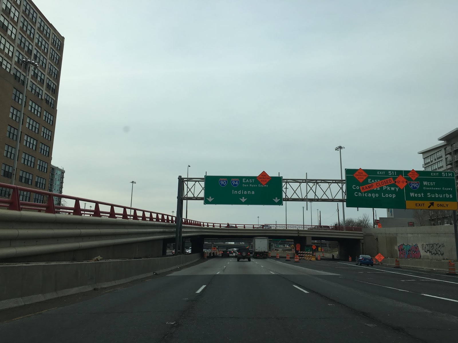
East of IL 64 traffic is advised of the upcoming junction at I-290/Eisenhower Expressway at Exit 51 H/I.

Approaching Ohio Street at Exit 50B I-90/I-94/Kennedy Expressway eastbound has a hell of a view of downtown Chicago. Ohio Street is the most direct access from the eastbound Kennedy Expressway to Navy Pier.


The Kennedy Expressway has a massive amount of exits at mile marker 51 in downtown Chicago with the highest ascending to H/I for I-290. Of note; former US Route 66 on Adams Street and Jackson Boulevard can be accessed from Exit F/G. The Kennedy Expressway terminates at I-290 and I-90/I-94 east join the Dan Ryan Expressway.


The Kennedy Expressway is a designation of 17.8 miles of freeway consisting parts of Interstate 190, 90 and 94 between Chicago O'Hare and I-290 in downtown Chicago. Expressway designations in the Chicago Area refer to free access freeway grades as opposed to limited access toll roads. Much of the Interstate network around Chicago consists of toll road segments. In the case of the Kennedy Expressway the free designation has made it the main east/west arterial freeway in the Chicago area which carries a massive peak daily traffic count of approximately 327,000 vehicles.
In short; construction of the Kennedy Expressway began in 1955 with portions opening 1958. The entirety of the Kennedy Expressway opened in November 1960 with reversible lanes opening up in early 1961. The original name of the Kennedy Expressway was known as the "Northwest Expressway" and was designated as Illinois State Route 194 from Chicago O'Hare east to I-94. I-90 at the time was routed along the Eisenhower Expressway which is now I-290. In November of 1963 the Northwest Expressway was officially re-designated as the Kennedy Expressway following the assassination of President John F. Kennedy. In 1978 I-90 was routed onto the Kennedy Expressway via the Jane Addams Memorial Tollway east over what was IL 194 to a multiplex of I-94. I-190 was also created in 1978 from the remaining segment of IL 194 on the Kennedy Expressway from Chicago O'Hare to I-90.
A much more detailed historic overview of the Kennedy Expressway can be found on Chicagoroads.com.
chicagoroads.com on the Kennedy Expressway
My drive on the Kennedy Expressway began from the Chicago O'Hare rental car parking lot on US 12/US 45 on Mannheim Road. US 12/US 45 connects with the Kennedy Expressway via I-190. Both I-190 and the Kennedy Expressway have a western terminus at the main domestic terminal building of Chicago O'Hare.


The first major junction east of US 12/US 45 on the Kennedy Expressway/I-190 is in Rosemont at Exit 1C/1D for I-294 Tollway. I-90 west traffic is directed to take Exit 1C for I-294 northbound.


The last Rosemont Exit on the Kennedy Expressway/I-190 eastbound is at River Road. East of River Road I-190 terminates and the Kennedy Expressway merges onto I-90 in the City Limits of Chicago. The first major junction on the I-90 portion of the Kennedy Expressway is at Exit 79A/B for IL 171 on Cumberland Avenue.


It quickly becomes apparent how heavy traffic is on the I-90 portion of the Kennedy Expressway by looking at the traffic time VMS signage. The merge portion for I-94 on the Kennedy Expressway is usually quickly reached but beyond that traffic tends to grind to a crawl. The Kennedy Expressway likely is the source of the road meme that "Chicago is an hour from Chicago."

The next major junction on the I-90 portion of the eastbound Kennedy Expressway is at Exit 81A for IL 43 on Harlem Avenue.


The I-90 portion of the eastbound Kennedy Expressway features reversible express lanes. The express lane signage is controlled via a digital VMS.


Near Montrose Avenue I-94 merges onto the Kennedy Expressway and joins I-90. The next major highway junction on the I-90 portion of the Kennedy Expressway is at Exit 44A for IL 19 on Irving Park Road. Exit 45A accesses Addison Street which is the main roadway east to Wrigley Field.

Additional Express Lanes for I-90/I-94 Kennedy Expressway can be found east of IL 19. The second set of Express Lanes remain segregated from the mainline lanes until Ohio Street.


IL 64 can be accessed from I-90/I-94/Kennedy Expressway eastbound via Exit 48B.


East of IL 64 traffic is advised of the upcoming junction at I-290/Eisenhower Expressway at Exit 51 H/I.

Approaching Ohio Street at Exit 50B I-90/I-94/Kennedy Expressway eastbound has a hell of a view of downtown Chicago. Ohio Street is the most direct access from the eastbound Kennedy Expressway to Navy Pier.


The Kennedy Expressway has a massive amount of exits at mile marker 51 in downtown Chicago with the highest ascending to H/I for I-290. Of note; former US Route 66 on Adams Street and Jackson Boulevard can be accessed from Exit F/G. The Kennedy Expressway terminates at I-290 and I-90/I-94 east join the Dan Ryan Expressway.


Comments