
This past weekend I had was up in the Sacramento River Delta and drove both State Highway Ferry Routes; California State Route 84 via the Real McCoy Ferry and CA 220 via the J-Mack Ferry.
Both State Highway Ferry routes crosses the waters of the Sacramento River Delta to Ryer Island. My approach to Ryer Island began in Solano County on CA 12 heading westbound over the Rio Vista Bridge. As traffic is approaching the western flank of the Rio Vista Bridge there is an exit for the north segment of CA 84. Said CA 84 exit directs traffic to downtown Rio Vista and Ryer Island. Oddly CA 84 isn't signed on westbound CA 12 but is on eastbound CA 12.


CA 84 is actually signed north of Rio Vista just not very well. I only encountered two reassurance shields: the first being below the Rio Vista Bridge. Traffic on CA 84 is advised that Ryer Island is only two miles to the north.


Most of the signage on CA 84 is old and still has button-copy. Sacramento is signed as 36 miles northward from CA 12.

As CA 84 approaches the Sacramento River the full width of the Rio Vista Bridge on CA 12 can be seen. The Rio Vista Bridge is a vertical lift span which was gradually built upon the site of an earlier bascule bridge between 1943 and 1960. The Rio Vista Bridge is 2,890 in length and has a 135-foot clearance when its vertical span is raised. The Rio Vista Bridge is infamous for long delays due to freight shipping traffic on the Sacramento River and averages about 20,000 vehicles a day. Various studies have been conducted to research a replacement span, but none have had much viability or much public support.

CA 84 gradually winds north along the shore of the Sacramento River before splitting north to Cache Slough. The Ryer Island Ferry and the Real McCoy II are located at the confluence of Cache Slough and Steamboat Slough.


The Ryer Island Ferry is operated by the Real McCoy II which crosses Cache Slough every 20 minutes. The Real McCoy II has a capacity 80 combined tons, and the vessel is relatively new having only replaced the Real McCoy I in 2011.


Cache Slough is part of the Sacramento River Deep Water Channel which was completed in 1963. The deep waters of Cache Slough require the Real McCoy II to use its engines to cross unlike the nearby J-Mack Ferry. The Real McCoy I was originally a cable driven ferry when it first went into operation in 1945 but was retrofitted with diesel engines following the completion of the Sacramento River Deep Water Channel. Caltrans District 4 has a small article detailing the history of the Real McCoy I.
Caltrans District 4; History of the Real McCoy I
Fortunately, I was the first car in line to board the Real McCoy II and was able to watch it approach with a vehicle from Ryer Island.


The approach to the Real McCoy II is very steep, traffic is advised to use low gear boarding. Parked traffic on the Real McCoy II is directed to shut their engines off and engage the parking brake.


Disembarking traffic on the Real McCoy II is directed towards Sacramento on CA 84. Oddly traffic towards Ryde via the J-Mack Ferry is advised to use Ryer Road at the southern tip of Ryer Island instead of CA 220. CA 84 traffic is advised that the Ryer Island levee is not for public use.


Traffic on CA 84 is advised that the next four miles of highway atop the Ryer Island Levee is curvy. The roadway quality of CA 84 on Ryer Island is very poor and is barely two lanes. Drop-offs are steep on both sides of the Ryer Island Levee. Ryer Island is entirely contained within Solano County and is bounded by; Cache Slough, Miner Slough, and Steamboat Slough.


At Postmile SOL 7.25 CA 84 meets an unsigned junction with CA 220 at the center of Ryer Island. The only indication that CA 220 is present from CA 84 is the Route 220 SOL 0.00 Postmile paddle.

CA 220 on Ryer Island is unsigned heading eastbound. CA 220 as an overall route is only 6 miles in length with about half of said mileage of Ryer Island. CA 220 quickly drops from the Ryer Island Levee and traverses the center of Ryer Island. Ryer Island consists of mostly farmland and ranch homes. CA 220 has a small crossing over Elkhorn Slough in the middle of Ryer Island.


At Ryer Road CA 220 rises up onto the eastern segment of the Ryer Island Ferry along Ryer Road on Steamboat Slough and approaches Howard's Landing where the J-Mack Ferry is located.


The overall weight cargo capacity of the J-Mack is only 20 tons compared to the 80 tons of the Real McCoy II.

The J-Mack unlike the Real McCoy II is still operated by a cable pulley at the bottom of Steamboat Slough. J-Mack traffic is very speedy and operates whenever there is traffic demand. Traffic on the J-Mack is directed to engage parking brake and shut all engines off once boarded. The current J-Mack Ferry apparently dates back to 1969.


The J-Mack and CA 220 cross Steamboat Slough into Sacramento County. Traffic on CA 220 eastbound disembarks at Grand Island on a steep landing and directed to Grand Island Road south before splitting east across said island towards CA 160. Compared to Ryer Island the route of CA 220 on Grand Island is very well signed with several reassurance shields.


The route of CA 220 east across Grand Island drops down off the levee at Steamboat Slough and crosses to CA 160 in Ryde at the Sacramento River. The roadway isn't in great shape but is in much better condition than CA 84. CA 220 even has an "end" shield and placard combination in Ryde.


The Legislative History of both CA 84 and CA 220 ferry routes isn't very exciting. Both CA 84 and CA 220 over their respective ferry routes were part of Legislative Route Number 100 which was adopted LRN 11 in Ryde (CA 24, presently modern CA 160) and LRN 53 (CA 12) in Rio Vista in 1933.
CAhighways.org on LRN 100
Interestingly prior to LRN 100 there doesn't appear to have been regular ferry or road service to Ryer Island. I was able to find detailed maps of Solano County in 1878 and 1896 showing no clear ferry or road service to Ryer Island.
Geo Blum 1896 Sectional Map of; Colusa, Yolo, Napa, Butte, Yuba, Solano, and Sacramento Counties
1878 Sectional Map of Southern Solano County
In 1964 LRN 100 was renumbered to be part of the northern extent of CA 84 over the Ryer Island Ferry and CA 220 over Howard's Landing Ferry. The change from LRN 100 to CA 84 and CA 220 can be observed by comparing the 1963 and 1964 State Highway Maps.
1963 State Highway Map
1964 State Highway Map
The full route of CA 84 was ultimately meant to be connected by a unbuilt segment that was never between Livermore and Antioch. CA 84 would have replaced the CA 160 designation to CA 12 would have multiplexed over the Rio Vista Bridge. In 1981 the legislative definition of CA 84 cut it back to Rio Vista which created a gap in the highway which likely will never be resolved even if a new route from Livermore to Antioch is built.


CA 84 is actually signed north of Rio Vista just not very well. I only encountered two reassurance shields: the first being below the Rio Vista Bridge. Traffic on CA 84 is advised that Ryer Island is only two miles to the north.


Most of the signage on CA 84 is old and still has button-copy. Sacramento is signed as 36 miles northward from CA 12.

As CA 84 approaches the Sacramento River the full width of the Rio Vista Bridge on CA 12 can be seen. The Rio Vista Bridge is a vertical lift span which was gradually built upon the site of an earlier bascule bridge between 1943 and 1960. The Rio Vista Bridge is 2,890 in length and has a 135-foot clearance when its vertical span is raised. The Rio Vista Bridge is infamous for long delays due to freight shipping traffic on the Sacramento River and averages about 20,000 vehicles a day. Various studies have been conducted to research a replacement span, but none have had much viability or much public support.

CA 84 gradually winds north along the shore of the Sacramento River before splitting north to Cache Slough. The Ryer Island Ferry and the Real McCoy II are located at the confluence of Cache Slough and Steamboat Slough.


The Ryer Island Ferry is operated by the Real McCoy II which crosses Cache Slough every 20 minutes. The Real McCoy II has a capacity 80 combined tons, and the vessel is relatively new having only replaced the Real McCoy I in 2011.


Cache Slough is part of the Sacramento River Deep Water Channel which was completed in 1963. The deep waters of Cache Slough require the Real McCoy II to use its engines to cross unlike the nearby J-Mack Ferry. The Real McCoy I was originally a cable driven ferry when it first went into operation in 1945 but was retrofitted with diesel engines following the completion of the Sacramento River Deep Water Channel. Caltrans District 4 has a small article detailing the history of the Real McCoy I.
Caltrans District 4; History of the Real McCoy I
Fortunately, I was the first car in line to board the Real McCoy II and was able to watch it approach with a vehicle from Ryer Island.


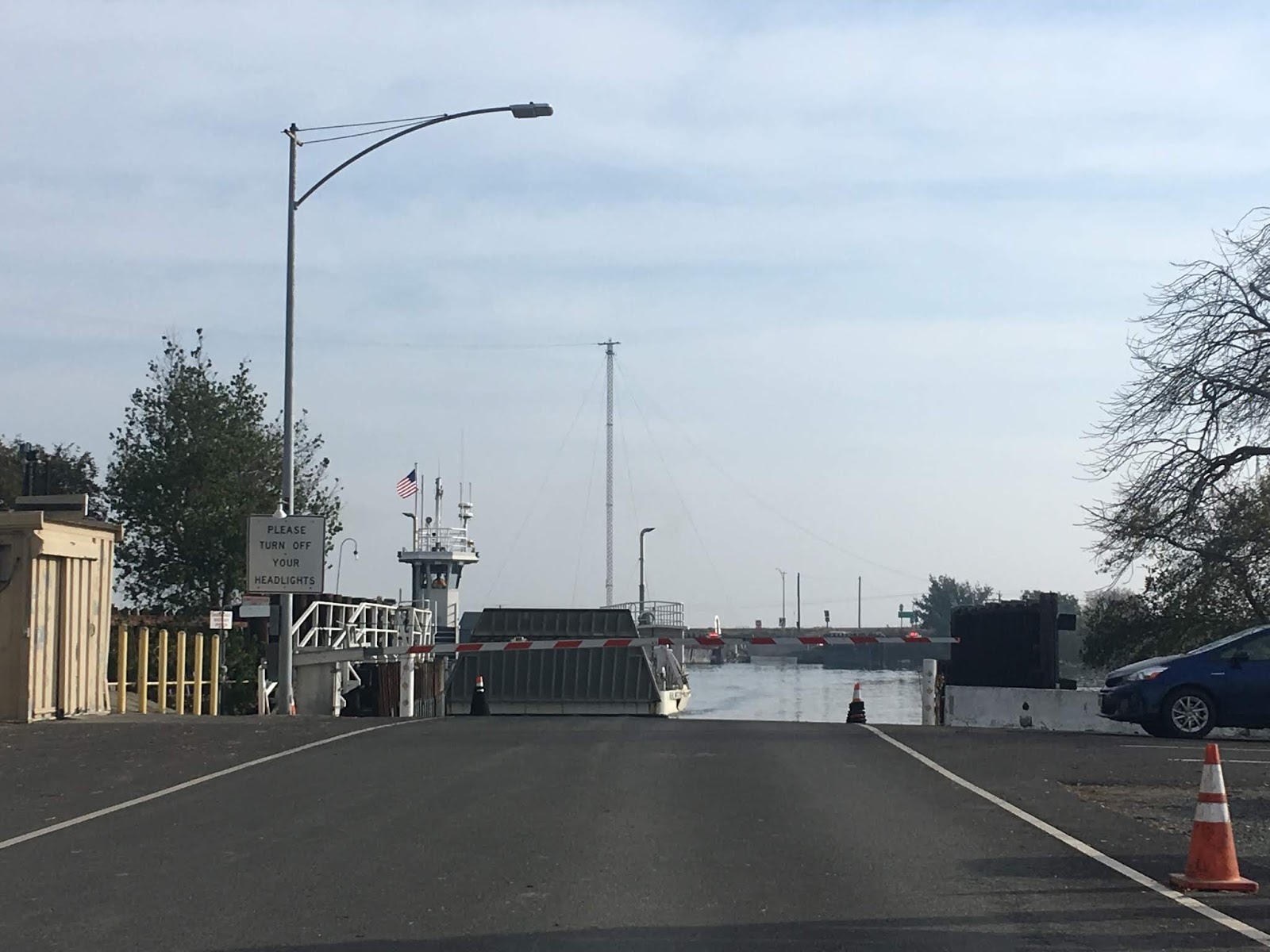


The approach to the Real McCoy II is very steep, traffic is advised to use low gear boarding. Parked traffic on the Real McCoy II is directed to shut their engines off and engage the parking brake.


Disembarking traffic on the Real McCoy II is directed towards Sacramento on CA 84. Oddly traffic towards Ryde via the J-Mack Ferry is advised to use Ryer Road at the southern tip of Ryer Island instead of CA 220. CA 84 traffic is advised that the Ryer Island levee is not for public use.


Traffic on CA 84 is advised that the next four miles of highway atop the Ryer Island Levee is curvy. The roadway quality of CA 84 on Ryer Island is very poor and is barely two lanes. Drop-offs are steep on both sides of the Ryer Island Levee. Ryer Island is entirely contained within Solano County and is bounded by; Cache Slough, Miner Slough, and Steamboat Slough.


At Postmile SOL 7.25 CA 84 meets an unsigned junction with CA 220 at the center of Ryer Island. The only indication that CA 220 is present from CA 84 is the Route 220 SOL 0.00 Postmile paddle.

CA 220 on Ryer Island is unsigned heading eastbound. CA 220 as an overall route is only 6 miles in length with about half of said mileage of Ryer Island. CA 220 quickly drops from the Ryer Island Levee and traverses the center of Ryer Island. Ryer Island consists of mostly farmland and ranch homes. CA 220 has a small crossing over Elkhorn Slough in the middle of Ryer Island.


At Ryer Road CA 220 rises up onto the eastern segment of the Ryer Island Ferry along Ryer Road on Steamboat Slough and approaches Howard's Landing where the J-Mack Ferry is located.


The overall weight cargo capacity of the J-Mack is only 20 tons compared to the 80 tons of the Real McCoy II.

The J-Mack unlike the Real McCoy II is still operated by a cable pulley at the bottom of Steamboat Slough. J-Mack traffic is very speedy and operates whenever there is traffic demand. Traffic on the J-Mack is directed to engage parking brake and shut all engines off once boarded. The current J-Mack Ferry apparently dates back to 1969.


The J-Mack and CA 220 cross Steamboat Slough into Sacramento County. Traffic on CA 220 eastbound disembarks at Grand Island on a steep landing and directed to Grand Island Road south before splitting east across said island towards CA 160. Compared to Ryer Island the route of CA 220 on Grand Island is very well signed with several reassurance shields.


The route of CA 220 east across Grand Island drops down off the levee at Steamboat Slough and crosses to CA 160 in Ryde at the Sacramento River. The roadway isn't in great shape but is in much better condition than CA 84. CA 220 even has an "end" shield and placard combination in Ryde.


The Legislative History of both CA 84 and CA 220 ferry routes isn't very exciting. Both CA 84 and CA 220 over their respective ferry routes were part of Legislative Route Number 100 which was adopted LRN 11 in Ryde (CA 24, presently modern CA 160) and LRN 53 (CA 12) in Rio Vista in 1933.
CAhighways.org on LRN 100
Interestingly prior to LRN 100 there doesn't appear to have been regular ferry or road service to Ryer Island. I was able to find detailed maps of Solano County in 1878 and 1896 showing no clear ferry or road service to Ryer Island.
Geo Blum 1896 Sectional Map of; Colusa, Yolo, Napa, Butte, Yuba, Solano, and Sacramento Counties
1878 Sectional Map of Southern Solano County
In 1964 LRN 100 was renumbered to be part of the northern extent of CA 84 over the Ryer Island Ferry and CA 220 over Howard's Landing Ferry. The change from LRN 100 to CA 84 and CA 220 can be observed by comparing the 1963 and 1964 State Highway Maps.
1963 State Highway Map
1964 State Highway Map
The full route of CA 84 was ultimately meant to be connected by a unbuilt segment that was never between Livermore and Antioch. CA 84 would have replaced the CA 160 designation to CA 12 would have multiplexed over the Rio Vista Bridge. In 1981 the legislative definition of CA 84 cut it back to Rio Vista which created a gap in the highway which likely will never be resolved even if a new route from Livermore to Antioch is built.
Comments