Infamous and the subject of much controversy the Pasadena Gap in the Long Beach Freeway has long existed as a contentious topic regarding the completion of Interstate 710 and California State Route 710. While the Pasadena Gap of the Long Beach Freeway effectively has been legislatively blocked the action only came after decades of controversy. While the Pasadena Gap of the Long Beach Freeway is fairly well known what many don't know is that a small segment was actually constructed south Interstate 210 and the Foothill Freeway. This disconnected segment of the Long Beach Freeway exists as the unsigned and largely hidden California State Route 710. On June 29, 2022 the California Transportation Commission relinquished California State Route 710 to the city of Pasadena. The blog cover above depicts a southward view on the completed Pasadena stub segment of the Long Beach Freeway which ends at California Boulevard.

Part 1; the history of the Pasadena Gap of the Long Beach Freeway and hidden California State Route 710As noted in the intro the hidden segment of California State Route 710 (CA 710) in Pasadena exists as the Long Beach Freeway from the Interstate 210/Foothill Freeway interchange south to California Boulevard. From California Boulevard hidden CA 710 is carried via a couplet on St. Johns Avenue and Pasadena Avenue south to Columbia Street exists as a temporary routing. Specifically hidden CA 710 exists from Postmiles LA T30.953 to R32.72.
The origins of the Pasadena Gap in the Long Beach Freeway begin with the original CA 15 and
Legislative Route Number 167 (LRN 167). As originally defined in 1933 LRN 167 ended at LRN 26 (then US Route 60 and later also US Route 99-70) in Monterey Park. The initial run of Sign State Routes was announced in the
August 1934 California Highways & Public Works. CA 15 was defined as following LRN 167 to a terminus US Route 99-60-70/LRN 26 in Monterey Park via Atlantic Boulevard (later Atlantic Avenue).
1949 Legislative Chapter 1467 extended the definition of LRN 167 north from US Route 99-60-70/LRN 26 in Monterey Park to US Route 66/LRN 205 at the Arroyo Seco Parkway. The extended definition of LRN 167 appears on the
1950 Division of Highways Map as a planned highway between US Route 99-60-70/LRN 26 in Monterey Park and US Route 66/LRN 205 in South Pasadena.
The
May/June 1951 California Highways & Public Works announced the planned Los Angeles River Freeway grade of CA 15/LRN 167 had been renamed the "Long Beach Freeway." The article stub notes the Long Beach Freeway name had been adopted by a Los Angeles County Board of Supervisors resolution. The origins of the Long Beach Freeway are stated to have been conceptualized 14 years prior by the Long Beach City Engineering Department.
1951 Legislative Chapter 1562 truncated the planned routing of LRN 167 to Huntington Drive in Alhambra. The truncated definition and planned routing of LRN 167 to Huntington Drive appears on the
1952 Division of Highways Map.
The location of the Long Beach Freeway from the Santa Ana Freeway to Huntington Drive was adopted by the California Highway Commission on July 24, 1953. Ultimately 1959 Legislative Chapter 1062 extended the northern terminus of LRN 167 to US Route 66A/CA 11/LRN 9 in Pasadena. LRN 167 thusly appears on the
1960 Division of Highways Map as a planned freeway with no adopted routing north of Huntington Drive to US Route 66A/CA 11/LRN 9.


The Division of Highways began location studies on the Pasadena extension of LRN 167 and the Long Beach Freeway during 1960. On April 21, 1960, the State formally notified the cities of Pasadena, South Pasadena and Alhambra that studies were being initiated for the location of the Long Beach Freeway from Huntington Drive to the Foothill Freeway. The
March/April 1961 California Highways & Public Works notes Senate Bill 480 established a 1.7-mile extension of the Long Beach Freeway from the city of Alhambra to near the junction of the Foothill-Pasadena Freeways. The Long Beach Freeway extension is stated to be under advanced planning along with the north/south leg of the Foothill Freeway through Pasadena.

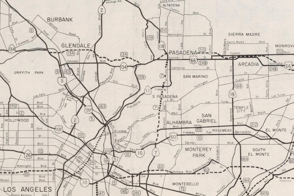
The 1964 California State Highway Renumbering had numerous impacts on the Long Beach Freeway corridor. LRN 167 along with the other Legislative Route Numbers were dropped in favor of field signage. CA 15 was replaced with the second iteration of CA 7 to make room to avoid duplication with Interstate 15. The
1964 Division of Highways Map displays the second iteration of CA 7 as the planned but unadopted outing of the Long Beach Freeway through Pasadena.


Project Report VII-232 dated February 19, 1964, identified seven corridors for the Long Beach Freeway through Pasadena. According to cahighways.org it was suggested the connection to Interstate 210/Foothill Freeway be routed through Figueroa Canyon. This was later dropped from a consideration following public hearings in Pasadena. The California Highway Commision adopted the Green-Red Line as documented in their reported findings dated November 18th, 1964. This corridor came to be known as the "Merdian Route" between Huntington Drive and Interstate 210.
The adopted routing of the Long Beach Freeway from Huntington Drive to Interstate 210 is announced in the
January/February 1965 California Highways & Public Works. The article stub notes the routing of Long Beach Freeway extension was adopted along with 77 freeway miles from 10 routes during the September-December California Highway Commission meetings. CA 7 and the Long Beach Freeway are noted to be under construction from CA 212/Valley Boulevard to Huntington Drive. Note, the Long Beach Freeway opened between Interstate 10 north to CA 212/Valley Boulevard during February 1965.


The city of Los Angeles signed a freeway agreement for the Long Beach Freeway extension during April 1965 which was followed by Alhambra during May 1966. During February 1967 the city of Pasadena approved the alignment of the Long Beach Freeway and signed a freeway agreement with the Division of Highways on March 30, 1967. The Federal Highway Administration (FHWA) approved the adopted extension of the Long Beach Freeway. The city of South Pasadena requested a reconsideration of the routing of the Long Beach Freeway extension three times which were all denied.
During November 1969 the California Highway Commission directed the Division of Highways to study the proposed Westerly Route alignment proposed by the city South Pasadena for the Long Beach Freeway extension. During January 1970 National Environmental Policy Act was signed into law on the Federal Level which was followed by the California Environmental Quality Act during November 1970. Both the National Environmental Policy Act and California Environment Quality Act would prove to be future obstructions to the Long Beach Freeway extension largely due to the require of Environmental Impact Studies (EIS).
The Division of Highways issued its Adopted Line Report during February 1972 which was accepted by Pasadena during the following March. The city of South Pasadena reaffirmed their recommendation of the Westerly Route for the Long Beach Freeway extension during April 1972. The California Highway Commission would go on to conclude the Westerly Route was not feasible during November 1972.
Caltrans (formed during January 1973) released an Environmental Impact Report on the Long Beach Freeway corridor between Interstate 10 to Huntington Drive. The city of South Pasadena the same month would file a lawsuit to stop construction of the Long Beach Freeway extension pending compliance with the National Environmental Policy Act and California Environmental Quality Act. Following an injunction being ordered during 1973 the FHWA and Caltrans started the EIS process. Below is a summary (courtesy cahighways.org) of the timeline of the history of the Pasadena Gap in the Long Beach Freeway.
- December 23, 1974, a draft EIS was approved.
- March 1975 Caltrans released its draft EIS. Pasadena, South Pasadena and Alhambra agree to the "Plan C" alignment during July 1975. The Plan C alignment was a modification of the Westerly Alignment.
- August 1975 the State Legislature passed Assembly Bill 1716 (the Arroyo Seco Preservation Act) to prevent the Long Beach Freeway extension from encroaching on park land.
- September 1975, Caltrans tentatively approved the Plan C alignment.
- March 1976, Caltrans was nearing the completion of the one-way couplet known locally as the "Wishbone" on Pasadena Avenue and St. John Avenue. This segment included the portion of freeway which is now today part of unsigned CA 710.
- July 29, 1976, the first supplemental draft EIS was approved. The supplemental draft EIS addressed four additional alternatives which did not pass-through Arroyo Seco.
- August 1976, the Los Angeles County Supervisors supported completing the Long Beach Freeway to Huntington Drive.
- September 1976, Caltrans released its supplemental draft EIS. Public hearings and community workshops regarding the supplemental draft EIS were held during October-December 1976.
- December 1976, the cities of Los Angeles and Pasadena filed a lawsuit to completion of the gap in the Long Beach Freeway.
- June 1977, Caltrans submitted a proposed final EIS which presented a partial completion alternative as a preferred alternative. The FHWA rejected the proposed final EIS due to the route segmentation and lack of local agency support during August 1977.
- January 1978, Senate Bill 86 (known as the Roberti Bill) imposed conditions for state agencies disposing of residential properties.
- May 1980, the Los Angeles County Transportation Commission held public hearings on the Long Beach Freeway project location. The Los Angeles County Transportation Commission reaffirmed support for the completion of the Long Beach Freeway extension during July 1980.
- March 22, 1983, the second supplemental draft EIS was approved. The second draft EIS was mandated by Assembly Bill 1623 (enacted March 16, 1982) which established a process leading to a route selection for a freeway link.
Below the draft supplemental EIS from Caltrans (dated March 30, 1983) can be seen. The draft supplemental EIS depicts the differences in the Merdian Corridor and Westerly Corridor of the planned Long Beach Freeway extension.
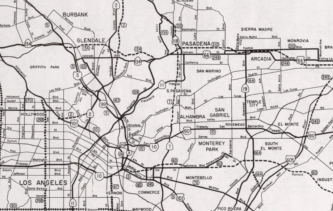
On September 23, 1983, Caltrans submitted an application to add CA 7 and the Long Beach Freeway from CA 1 in Long Beach to Interstate 10 to the Interstate System as Interstate 710. The American Association of State Highway Transportation Officials (AASHTO) approved the addition of Interstate 710 on May 24, 1984. During October 1984 the FHWA would approve the addition of Interstate 710 and the Long Beach Freeway from CA 1 to Interstate 10 as non-chargeable Interstate.
On December 8, 1984, AASHTO would approve a second request by Caltrans to extend Interstate 710 to Ocean Boulevard at the Port of Long Beach. 1984 Legislative Chapter 409 defined Route 710 as "Route 1 to Route 210" with additional conditions which would extend it to the Port of Long Beach. Interstate 710 and unsigned CA 710 in the Pasadena Gap both appear on the
1986 Caltrans Map.
- October 24, 1986, the third supplemental draft EIS was approved, which identified the new Meridian Variation Alternative as the locally preferred as the California Transportation Commission adopted alternative. The Meridian Variation Alternative was developed to lessen the impacts to historic properties in the Long Beach Freeway Pasadena Gap corridor.
- May 1988, a supplemental section evaluation to the third supplemental draft EIS was circulated. This documented addressed the impacts on the Prospect Circle Historic District which at the time was found to be eligible to the National Register of Historic Places.
- March 27, 1990, an environmental reevaluation was approved and concluded the third supplemental draft EIS was not necessary since there was no significant information since the 1986 second draft EIS.
- January 10, 1992, another environmental reevaluation was approved.
- March 2, 1992, the FHWA approved the 1988 evaluation for the Long Beach Freeway in the Pasadena Gap. Provisions required Caltrans to investigate all reasonable techniques and measures to reduce the footprint on the affected communities attached to the Long Beach Freeway Pasadena Gap corridor of CA 710. The FHWA added a stipulation that they would not execute the Record of Decision until Caltrans satisfied the provisions they established.
- January 15, 1993, the Meridian Variation Enhancement and mitigation Advisory Committee issued its final report. The Advisory Council on Historic Preservation referred the CA 710/Long Beach Freeway Pasadena Gap project to the Council on Environmental Quality over concerns over the impact on historic properties of a Low-Build Alternative. The Council on Environmental Quality did not accept the referral but recommended the FHWA and Advisory Council on Environmental Quality work together to update historic inventory and evaluation the feasibility of the Low-Build proposal.
- June 1993, the final report from the Route 710 Meridian Variation Enhancement and Mitigation Advisory Committee recommended several mitigations which were adopted by Caltrans and resulted in changes to the preferred alternative identified in the final EIS. A notable revision was the prohibition of trucks beyond local deliveries from the planned Long Beach Freeway in the Pasadena Gap.
- Following several years of discussions, the FHWA reached a
Record of Decision during April 1998. The FHWA Record of Decision selected the modified Meridian Variation Corridor. The planned corridor of CA 710 in the Pasadena Gap would include mostly a depressed grade along with some cut and cover tunnels. Below some of the alternatives proposed in the final EIS can be seen in a map published by the Los Angeles Times.
- 1999, U.S. District Court Judge Pregerson issued a preliminary injunction which prohibited Caltrans from proceeding with construction of CA 710 in the Pasadena Gap. Judge Pregerson identified violations of the Clean Air Act, Environmental Protection Act and Historic Preservation Act.
- 2002, Caltrans shelved plans to connect the gap in the Long Beach Freeway with a surface alignment of CA 710 in favor of a tunnel alternative.
- 2003, the FHWA withdrew their Record of Decision on the CA 710 Pasadena Gap corridor.
- 2004, the California Transportation Commission withdrew their Notice of Determination on the CA 710 Pasadena Gap corridor.
- August 2005, the State authorized studies to evaluate the technical feasibility and impacts of the Tunnel Alternative in the Long Beach Freeway Pasadena Gap.
- June 2006, the Los Angeles Times reported there was three possible routes for twin 4.5-mile tunnels which would connect the Long Beach Freeway from the terminus of Interstate 710 at Valley Boulevard in Alhambra to Interstate 210 in Pasadena:
1. Along the same path that had been suggested for the Meridian alignment.
2. A slightly longer path that would pass under the existing Fremont Avenue corridor.
3. A more eastern path that follow under Huntington Drive and Fair Oaks Avenue.
- 2009, the Los Angeles Times reported that the Long Beach Freeway tunnel study was completed and explored five zones. The tunnel studies concluded the tunneling routing of the Long Beach Freeway would be feasible and would be about 200 below the ground. The Los Angeles Times cited a finalized draft EIS was expected to be complete by 2010.
- February 2010, the Glendale Press reported the debate over the Long Beach Freeway tunnel alternative reinvigorated controversy in late 2009 when Caltrans and the Los Angeles County Metropolitain Authority released their feasibility study.
- May 2012, it was reported Caltrans and the Los Angeles County Metropolitain Authority was considering twelve options for the Pasadena Gap in the Long Beach Freeway along with a "no build" option.
- August 2012, Caltrans and the Los Angeles County Metropolitain Authority eliminated five of the twelve potential corridors for the Pasadena Gap of the Long Beach Freeway. The five listed remaining options were cited as:
A. No build.
B. Bus rapid transit route (BRT-6): from Los Angeles to Pasadena.
C. Light Rail (LR-4): from East Los Angeles to Pasadena.
D. Intelligent traffic system option.
E. F-7 tunnel alignment.
The proposed F-7 tunnel alignment in the Pasadena Gap of the Long Beach Freeway can be seen below.
- September 2012, the Los Angeles City Council voted to oppose any extension of CA 710 or the Long Beach Freeway.
- January 2013, the Los Angeles County Metropolitain Authority released an analysis of the remaining alternatives in the Pasadena Gap corridor of the Long Beach Freeway. The June 2013 the Los Angeles County Metropolitan Authority voted to block fast-track funding to close the gap in the Long Beach Freeway.
- October 2013, a bill was approved which directed Caltrans to sell nearly 500 properties it owned in Los Angeles, South Pasadena and Pasadena in the acquired right-of-way of the Pasadena Gap of the Long Beach Freeway. The same bill removed a surface alignment of the Long Beach Freeway in the Pasadena Gap from consideration.
- March 2015, the Los Angeles Times reported that any major modifications to the Route 710 freeway would cost billions of dollars and take years to complete. The draft EIS provided a number of options to address the 4.5-mile Pasadena Gap along with a "no build" option.
- Through 2015-2017 the Pasadena Gap faced continued resistance to all design options from various groups and government bodies. During February 2017 Assemblyman Chris Holden introduced legislation to prohibit construction of a tunnel in the Pasadena Gap of the Long Beach Freeway. During May 2017 the Los Angeles County Metropolitain Authority to pursue an alternative to the tunnel in the Pasadena Gap and connecting the Long Beach Freeway.
2019 Assembly Bill 29/Chapter 791 and Senate Bill 7/Chaptered 835 were chaptered on October 21, 2019, with the latter taking precedence. Senate Bill 7 changed the definition of Route 710 in the Freeway & Expressway system which removed the Pasadena Gap from the definition. Senate Bill 7 specifically required alterations of the legislative definition of Route 710 segment (2) and segment (3) which would become effective on January 1, 2024
(2) Route 1 near the City of Long Beach to Alhambra Avenue in the City of Los Angeles.
(3) California Boulevard in the City of Pasadena to Route 210.
Senate Bill explicitly deleted the unconstructed portion of Route 710 from the Freeway & Expressway system. Senate Bill 7 added Section 622.3 to the State Highway Code:
(a) Upon determination by the commission that it is in the best interest of the state to do so, the commission may, upon terms and conditions approved by it, relinquish to the City of Pasadena the portion of Route 710 within the jurisdictional limits of that city, if the department and city enter into an agreement providing for that relinquishment.
(b) A relinquishment under this section shall become effective on the date following the county recorder's recordation of the relinquishment resolution containing the commission's approval of the terms and conditions of the relinquishment.
(c) On and after the effective date of relinquishment, all the following shall occur:
(1) The relinquished portion of Route 710 shall cease to be a state highway.
(2) The relinquished portion of Route 710 shall be ineligible for future adoption under Section 81.
(3) The City of Pasadena shall ensure continuity of traffic flow on the relinquished portion of Route 710.
The California Transportation Commission acted to relinquish the unsigned stub of CA 710 and the Long Beach Freeway in Pasadena on June 29, 2022. It is unclear what will become of the unsigned stub of CA 710 in Pasadena. The relinquishment of stub of CA 710 was announced in the Pasadena-Star News:
Part 2; a drive on the hidden segment of California State Route 710 and the Long Beach Freeway in Pasadena
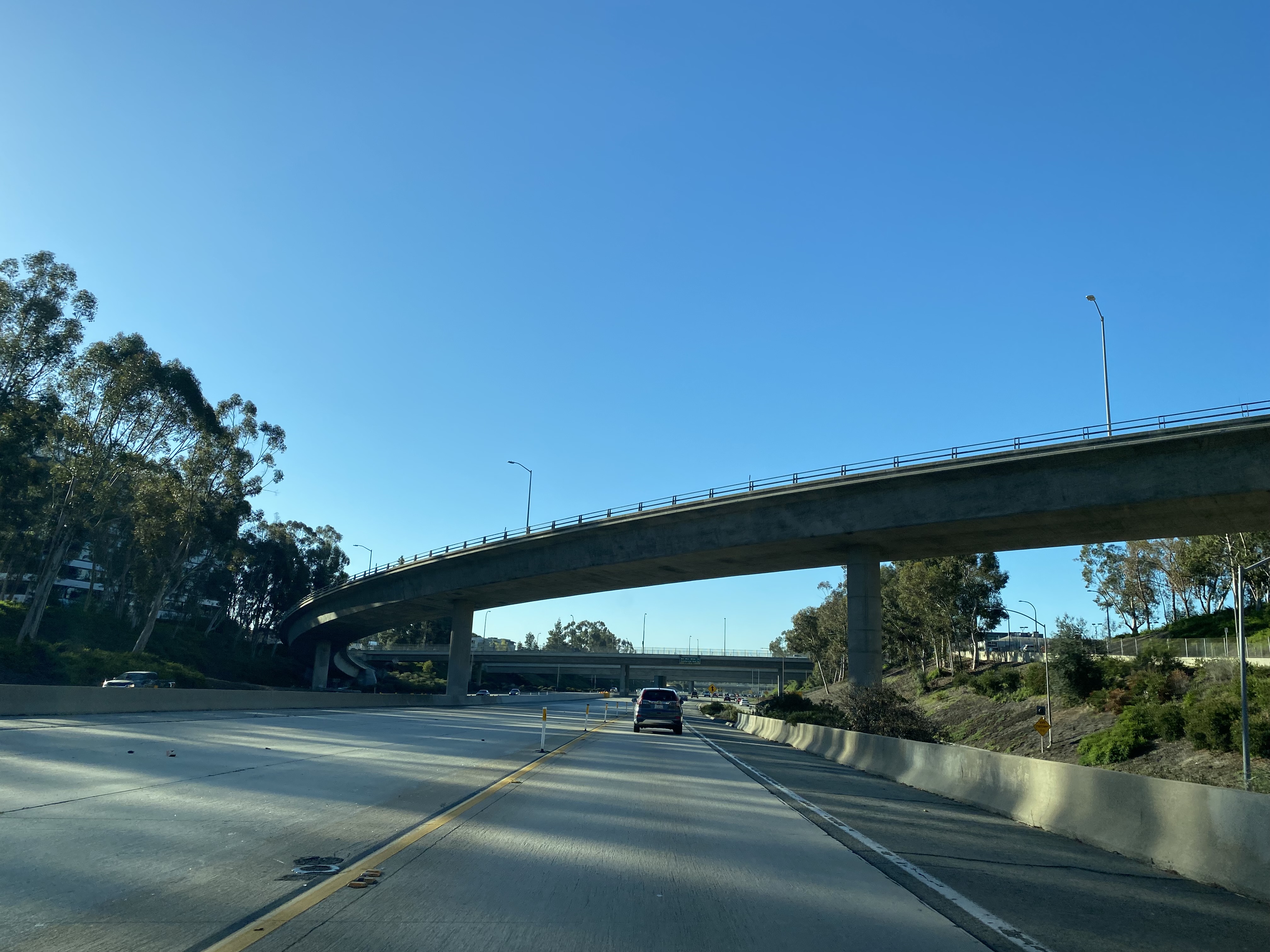
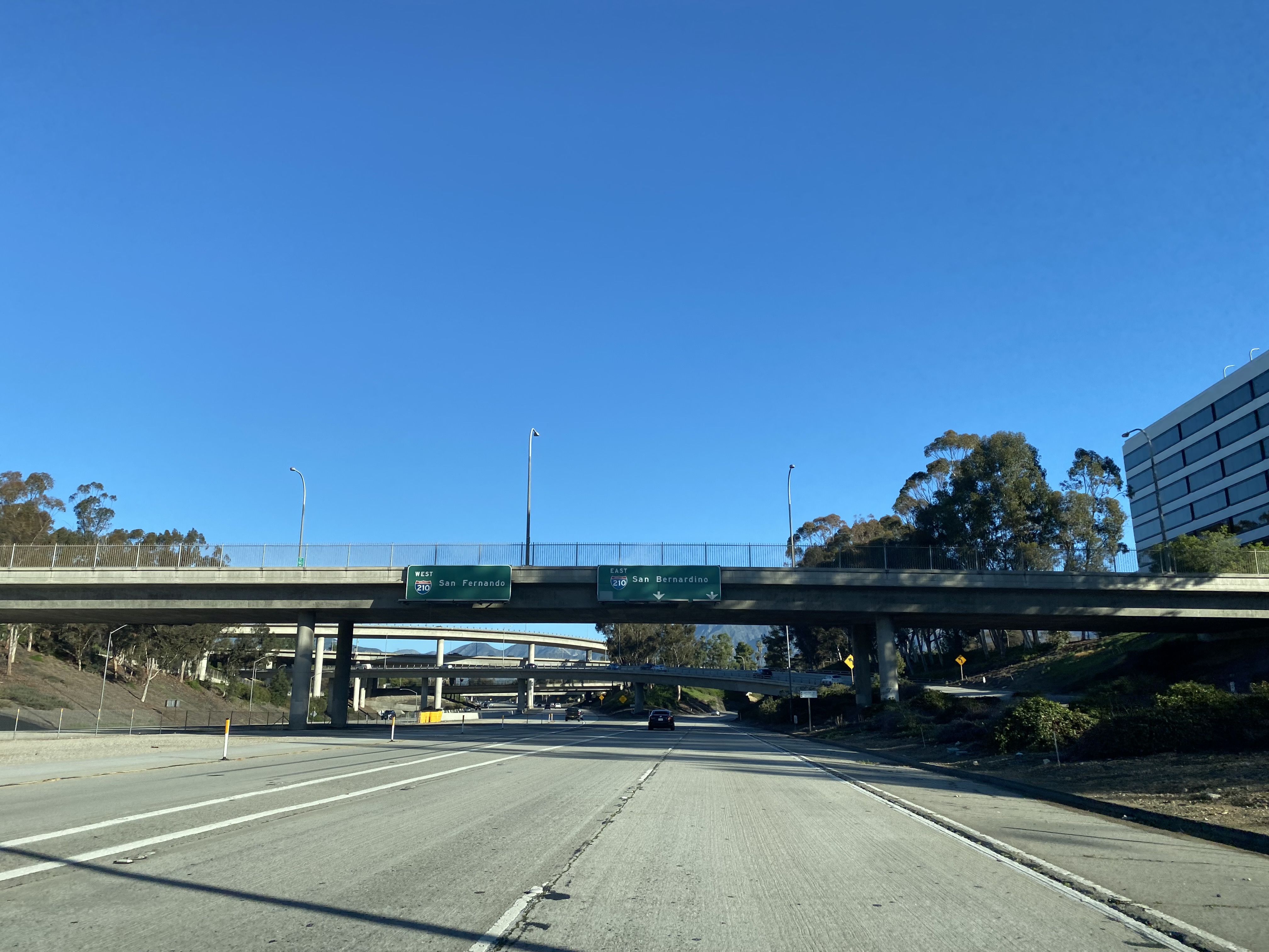
From westbound Interstate 210/Foothill Freeway traffic can access the unsigned stub of CA 710/Long Beach Freeway by following signage to Del Mar Boulevard and California Boulevard. Approaching the unsigned stub of CA 710 traffic can access Colorado Boulevard via Interstate 210 Exit 25A.
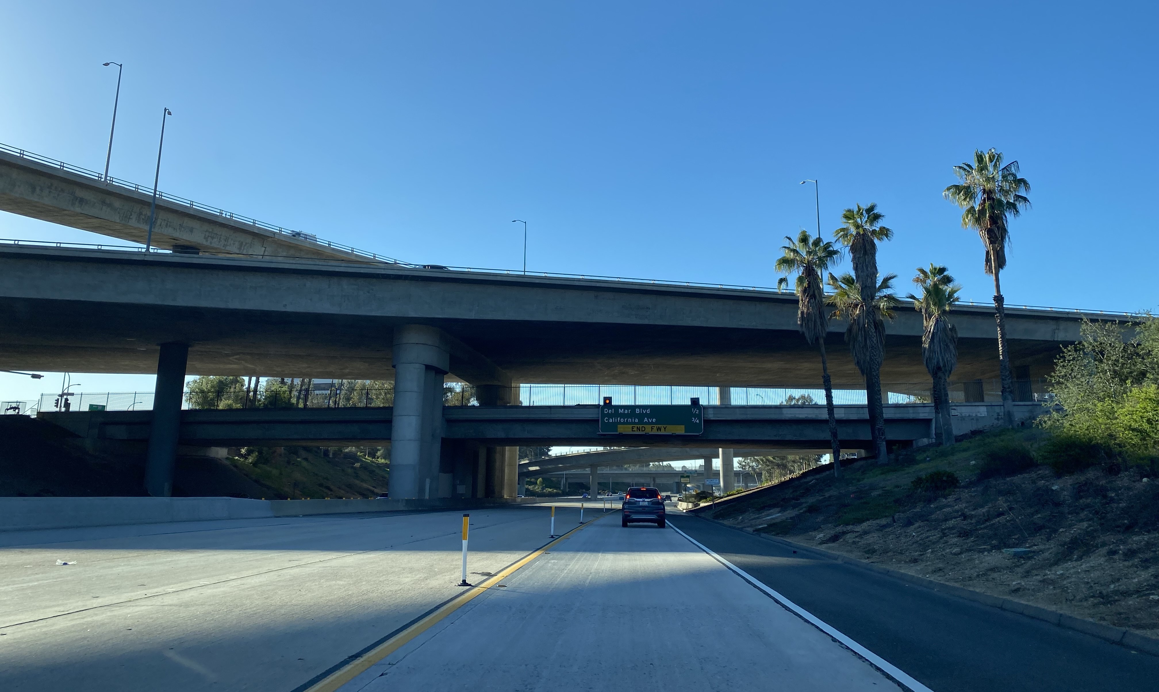
Unsigned CA 710 southbound crosses under CA 134/Ventura Freeway and Interstate 210/Foothill Freeway interchange. Traffic is advised Del Mar Boulevard is 0.5 miles away and California Avenue 0.75 miles away along with the end of the Long Beach Freeway stub.
Unsigned CA 710 southbound accesses Del Mar Avenue via an unnumbered Exit.
Unsigned CA 710 southbound transitions off the Long Beach Freeway stub at California Boulevard onto St. John Avenue. As noted in Part 1 unsigned CA 710 continues south via a temporary routing Columbia Street. Traffic headed to CA 110 and the Arroyo Seco Parkway is directed to head east on California Boulevard.
The northbound stub of the Long Beach Freeway can be found following unsigned CA 710 onto Pasadena Avenue where an access ramp can be found at Bellevue Drive. The entrance ramp to the Long Beach Freeway stub is signed as access to Interstate 210.
The northbound stub of the Long Beach Freeway carries unsigned CA 710 to Interstate 210. Traffic can only access CA 134 and the Ventura Freeway from a ramp located at Del Mar Avenue.


Comments