This past weekend I drove the section of California State Route 12 located in the Sacramento River Delta from Interstate 5 west to Interstate 80.

CA 12 is a 116 east/west State Highway which stretches from CA 116 in Sonoma County east to CA 49 Calaveras County. CA 12 was one of the original 1934 Signed State Highways but was made of various Legislative Route Numbers. Between I-5 and I-80 the 39 mile section of CA 12 was part of LRN 53. This blog in particular pertains to the LRN 53 section of CA 12, a description on the full route can be found at CAhighways.org.
Cahighways.org on CA 12
LRN 53 was first defined by the 1919 Third State Highway Bond Act according to CAhighways.org. Originally the routing LRN 53 only ran between Rio Vista and Fairfield which is reflected on the 1920 State Highway Map.
1920 State Highway Map
By 1921 the legislative definition of LRN 53 was extended east from Rio Vista to Lodi. The original alignment of LRN 53 east of Rio Vista took a far different path than CA 12 does today. The original alignment of LRN 53 from the Sacramento River and Sacramento County Line eastward to Lodi was as follows:
- Modern CA 160 on River Road along the Sacramento River to Isleton and Isleton Road.
- Isleton Road along the Sacramento River over Georgian Slough to Walnut Grove and River Road.
- River Road/Signed County Route J11 to Walnut Grove-Thorton Road.
- Walnut Grove-Thorton Road/Signed County Route J11 to the Mokelumne River and San Joaquin County Line to Walnut Grove Road.
- Walnut Grove Road/Signed County Route J11 to Thorton and Thorton Road.
- Thorton Road/Signed County Route J8 to Stockton Street.
- Stockton Street to Midsection Street.
- Midsection Street to Kile Road.
- Kile Road to Peltier Road/Signed County Route J12.
- Peltier Road/Signed County Route J12 to Devries Road.
- Devries Road to Turner Road.
- Turner Road to Sacramento Street in Lodi
- Sacramento Street in Lodi to Lockeford Street in Lodi.
- Lockeford Street in Lodi to LRN 4 at Cherokee Lane.
The above alignment can be observed on the 1922 State Highway Map, 1935 California Division of Highways Map of Sacramento County, and 1935 California Division of Highways Map of San Joaquin County.
1922 State Highway Map
1935 Sacramento County Highway Map
1935 San Joaquin County Highway Map
By 1940 a new proposed alignment of CA 12/LRN 53 can be seen on the State Highway Map. The new alignment of CA 12/LRN 53 carried the route east out of Isleton on:
- From CA 24; A Street to 4th Street.
- 4th Street to Jackson Boulevard.
- Jackson Boulevard to Jackson Slough Road.
- Jackson Slough Road to Terminous Road.
- East over modern CA 12 over Bouldin Island and Mokelumne River to Lodi at US 99/LRN 4.
Said 1940 State Highway Map can be viewed here.
1940 State Highway Map
By 1942 the above alignment is shown as completed on the State Highway Map.
1942 State Highway Map
A new CA 12 bypass route south of Isleton first appears on the 1959 State Highway Map.
1959 State Highway Map
My approach to CA 12 was from I-5 northbound in San Joaquin County. I departed I-5 at Exit 485 and turned west on CA 12 towards Fairfield.


From I-5 the route of CA 12 westbound is signed as Dana Cowell Memorial Highway.

Much of CA 12 between I-5 and I-80 is Safety Corridor. The CA 12 Safety Corridor has a large number of center-stripe concrete barriers in addition other passive means of preventing passing. According to CAhighways.org there has been over 800 traffic accidents on CA 12 between I-5 and I-80 since 2001. The slogan for the CA 12 corridor is the somewhat humorous "DRIVE TO STAY ALIVE!"

West of I-5 Rio Vista is signed as 14 miles away on CA 12 while Fairfield is signed at 38 miles.


At the confluence of the Mokelumne River and Little Potato Slough CA 12 westbound enters Terminous. Terminous supposedly gets it's name from the being the terminus point of a road from Lodi until CA 12 was routed through the community. Terminous also has an amusing road name of "Glasscock Road" jutting north of the community. CA 12 rises over Little Potato Slough on a draw span onto Bouldin Island.


CA 12 has a center barrier on Bouldin Island west to the crossing of the Mokelumne River.


After crossing the Mokelumne River CA 12 westbound enters Sacramento County.

CA 12 in Sacramento County is signed as the CHP Officer Charles "Chuck" Sorenson Memorial Highway.

CA 12 westbound has one major junction at CA 160 just before the Rio Vista Bridge. CA 160 is former segment of CA 24. CA 12 eastbound would have originally multiplexed CA 24 northbound into Isleton as stated above.

Previously I wrote about CA 160 northbound from CA 12 which can be found below:
Disaster Tourism Part 8; the San Joaquin-Sacramento River Delta
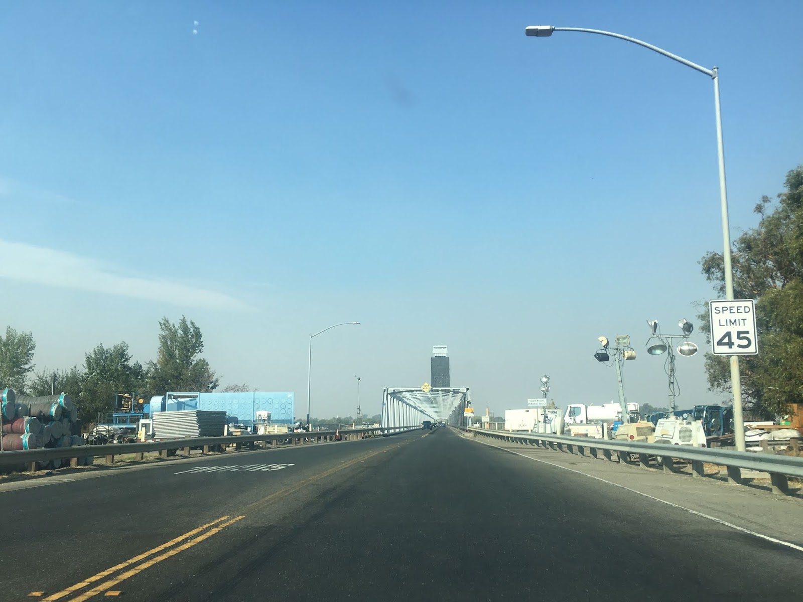
West of CA 160 the route of CA 12 crosses the Sacramento River on the Rio Vista Bridge into Solano County and Rio Vista. Officially the Rio Vista Bridge is known as the Helen Madere Memorial Bridge. The modern Rio Vista Bridge is a Vertical-Lift Through Truss design which 2,890 feet in length. The modern Rio Vista Bridge gradually replaced parts of the 1919 bascule span and was under some form of construction between 1943 to 1960. Today the Rio Vista Bridge is mostly known for infamous gear failures which have created 80 mile detour routes around CA 12.


As CA 12 westbound it has a junction with the northern section of CA 84. CA 84 continues northward to the Ryers Island Ferry over Cache Slough which is one of two remaining in the State Highway System. Rio Vista dates back to Mexican Land Grants, the community was originally located at the confluence of the Sacramento River and Cache Slough until heavy floods in 1862 which is ironically close to the Ryers Island Ferry.


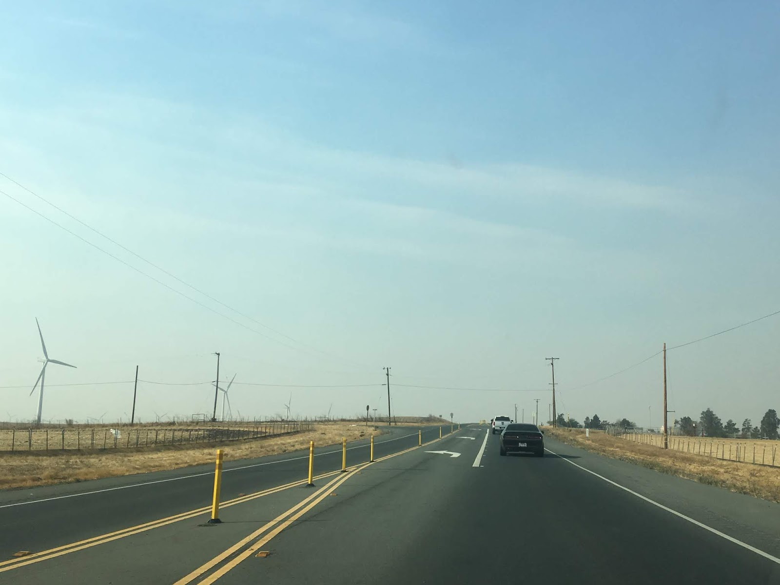
Exiting Rio Vista CA 12 westbound is signed as 21 miles away from Fairfield and enters another Safety Corridor with solid yellow lines.


The CA 12 Safety Corridor has numerous passing lanes all the way west to CA 113.


CA 12 west of CA 113 is signed as the Officer David Frank Lamoree Memorial Highway.

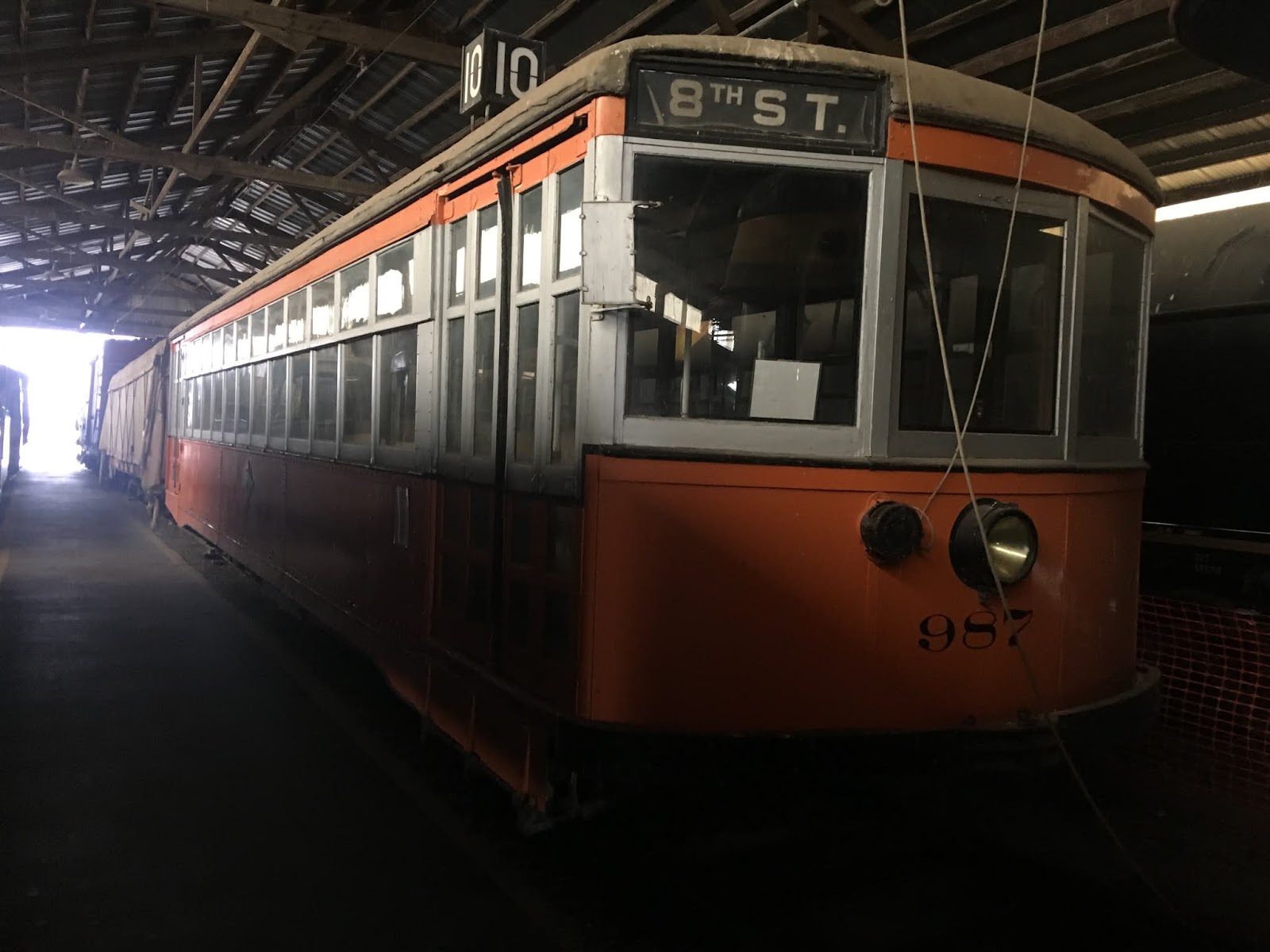
A couple miles past the junction with the CA 113 junction the route of CA 12 crosses over the former mainline of the Sacramento Northern Railway which is the headquarters of the Western Railway Museum.


The Western Railroad Museum opened in 1960 and mostly features primarily interurban rail locomotives and cars. In 1994 the Western Railroad Museum purchased 22 miles of the Sacramento Northern Railway. The Sacramento Northern Railway was a line of interurban rail lines between Chico south to the San Francisco Bay Area which stretched 183 miles. The Sacramento Northern Railway is mostly known for the rail cars that ran on the lower deck of the original Bay Bridge. The Sacramento Northern Railroad has roots dating back to 1905 with the Northern Electric Railway. The Sacramento Northern Railroad was purchased by the Union Pacific in 1983.


CA 12 westbound past CA 113 continues through a Safety Corridor west to the limits of Suisun City. CA 12 westbound originally utilized Denverton Road, Creed Road, and Petersen Road through modern day Travis Air Force Base to reach Suisun City.


CA 12 westbound opens up to a four-lane surface expressway from Suisun City west through Fairfield to I-80. The expressway alignment essentially is on the same right-of-way the route has always been on.


Entering Fairfield CA 12 westbound is signed as the Solano County Deputy Sheriff Hale Humphrey Memorial Highway.


I didn't make all the way to I-80 on CA 12 westbound but rather about a half mile away where I pulled off at Beck Road. My destination was a family tour at the Jelly Belly Factory located at 1 Jelly Belly Lane.


CA 12 is a 116 east/west State Highway which stretches from CA 116 in Sonoma County east to CA 49 Calaveras County. CA 12 was one of the original 1934 Signed State Highways but was made of various Legislative Route Numbers. Between I-5 and I-80 the 39 mile section of CA 12 was part of LRN 53. This blog in particular pertains to the LRN 53 section of CA 12, a description on the full route can be found at CAhighways.org.
Cahighways.org on CA 12
LRN 53 was first defined by the 1919 Third State Highway Bond Act according to CAhighways.org. Originally the routing LRN 53 only ran between Rio Vista and Fairfield which is reflected on the 1920 State Highway Map.
1920 State Highway Map
By 1921 the legislative definition of LRN 53 was extended east from Rio Vista to Lodi. The original alignment of LRN 53 east of Rio Vista took a far different path than CA 12 does today. The original alignment of LRN 53 from the Sacramento River and Sacramento County Line eastward to Lodi was as follows:
- Modern CA 160 on River Road along the Sacramento River to Isleton and Isleton Road.
- Isleton Road along the Sacramento River over Georgian Slough to Walnut Grove and River Road.
- River Road/Signed County Route J11 to Walnut Grove-Thorton Road.
- Walnut Grove-Thorton Road/Signed County Route J11 to the Mokelumne River and San Joaquin County Line to Walnut Grove Road.
- Walnut Grove Road/Signed County Route J11 to Thorton and Thorton Road.
- Thorton Road/Signed County Route J8 to Stockton Street.
- Stockton Street to Midsection Street.
- Midsection Street to Kile Road.
- Kile Road to Peltier Road/Signed County Route J12.
- Peltier Road/Signed County Route J12 to Devries Road.
- Devries Road to Turner Road.
- Turner Road to Sacramento Street in Lodi
- Sacramento Street in Lodi to Lockeford Street in Lodi.
- Lockeford Street in Lodi to LRN 4 at Cherokee Lane.
The above alignment can be observed on the 1922 State Highway Map, 1935 California Division of Highways Map of Sacramento County, and 1935 California Division of Highways Map of San Joaquin County.
1922 State Highway Map
1935 Sacramento County Highway Map
1935 San Joaquin County Highway Map
By 1940 a new proposed alignment of CA 12/LRN 53 can be seen on the State Highway Map. The new alignment of CA 12/LRN 53 carried the route east out of Isleton on:
- From CA 24; A Street to 4th Street.
- 4th Street to Jackson Boulevard.
- Jackson Boulevard to Jackson Slough Road.
- Jackson Slough Road to Terminous Road.
- East over modern CA 12 over Bouldin Island and Mokelumne River to Lodi at US 99/LRN 4.
Said 1940 State Highway Map can be viewed here.
1940 State Highway Map
By 1942 the above alignment is shown as completed on the State Highway Map.
1942 State Highway Map
A new CA 12 bypass route south of Isleton first appears on the 1959 State Highway Map.
1959 State Highway Map
My approach to CA 12 was from I-5 northbound in San Joaquin County. I departed I-5 at Exit 485 and turned west on CA 12 towards Fairfield.


From I-5 the route of CA 12 westbound is signed as Dana Cowell Memorial Highway.

Much of CA 12 between I-5 and I-80 is Safety Corridor. The CA 12 Safety Corridor has a large number of center-stripe concrete barriers in addition other passive means of preventing passing. According to CAhighways.org there has been over 800 traffic accidents on CA 12 between I-5 and I-80 since 2001. The slogan for the CA 12 corridor is the somewhat humorous "DRIVE TO STAY ALIVE!"

West of I-5 Rio Vista is signed as 14 miles away on CA 12 while Fairfield is signed at 38 miles.


At the confluence of the Mokelumne River and Little Potato Slough CA 12 westbound enters Terminous. Terminous supposedly gets it's name from the being the terminus point of a road from Lodi until CA 12 was routed through the community. Terminous also has an amusing road name of "Glasscock Road" jutting north of the community. CA 12 rises over Little Potato Slough on a draw span onto Bouldin Island.


CA 12 has a center barrier on Bouldin Island west to the crossing of the Mokelumne River.


After crossing the Mokelumne River CA 12 westbound enters Sacramento County.

CA 12 in Sacramento County is signed as the CHP Officer Charles "Chuck" Sorenson Memorial Highway.

CA 12 westbound has one major junction at CA 160 just before the Rio Vista Bridge. CA 160 is former segment of CA 24. CA 12 eastbound would have originally multiplexed CA 24 northbound into Isleton as stated above.

Previously I wrote about CA 160 northbound from CA 12 which can be found below:
Disaster Tourism Part 8; the San Joaquin-Sacramento River Delta
West of CA 160 the route of CA 12 crosses the Sacramento River on the Rio Vista Bridge into Solano County and Rio Vista. Officially the Rio Vista Bridge is known as the Helen Madere Memorial Bridge. The modern Rio Vista Bridge is a Vertical-Lift Through Truss design which 2,890 feet in length. The modern Rio Vista Bridge gradually replaced parts of the 1919 bascule span and was under some form of construction between 1943 to 1960. Today the Rio Vista Bridge is mostly known for infamous gear failures which have created 80 mile detour routes around CA 12.


As CA 12 westbound it has a junction with the northern section of CA 84. CA 84 continues northward to the Ryers Island Ferry over Cache Slough which is one of two remaining in the State Highway System. Rio Vista dates back to Mexican Land Grants, the community was originally located at the confluence of the Sacramento River and Cache Slough until heavy floods in 1862 which is ironically close to the Ryers Island Ferry.


Exiting Rio Vista CA 12 westbound is signed as 21 miles away from Fairfield and enters another Safety Corridor with solid yellow lines.


The CA 12 Safety Corridor has numerous passing lanes all the way west to CA 113.


CA 12 west of CA 113 is signed as the Officer David Frank Lamoree Memorial Highway.

A couple miles past the junction with the CA 113 junction the route of CA 12 crosses over the former mainline of the Sacramento Northern Railway which is the headquarters of the Western Railway Museum.


The Western Railroad Museum opened in 1960 and mostly features primarily interurban rail locomotives and cars. In 1994 the Western Railroad Museum purchased 22 miles of the Sacramento Northern Railway. The Sacramento Northern Railway was a line of interurban rail lines between Chico south to the San Francisco Bay Area which stretched 183 miles. The Sacramento Northern Railway is mostly known for the rail cars that ran on the lower deck of the original Bay Bridge. The Sacramento Northern Railroad has roots dating back to 1905 with the Northern Electric Railway. The Sacramento Northern Railroad was purchased by the Union Pacific in 1983.


CA 12 westbound past CA 113 continues through a Safety Corridor west to the limits of Suisun City. CA 12 westbound originally utilized Denverton Road, Creed Road, and Petersen Road through modern day Travis Air Force Base to reach Suisun City.


CA 12 westbound opens up to a four-lane surface expressway from Suisun City west through Fairfield to I-80. The expressway alignment essentially is on the same right-of-way the route has always been on.


Entering Fairfield CA 12 westbound is signed as the Solano County Deputy Sheriff Hale Humphrey Memorial Highway.


I didn't make all the way to I-80 on CA 12 westbound but rather about a half mile away where I pulled off at Beck Road. My destination was a family tour at the Jelly Belly Factory located at 1 Jelly Belly Lane.


Comments